 |
|
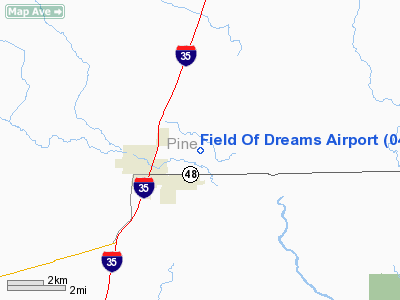
Location & QuickFacts
| FAA Information Effective: | 2008-09-25 |
| Airport Identifier: | 04W |
| Airport Status: | Operational |
| Longitude/Latitude: | 092-53-42.6279W/46-01-22.3252N
-92.895174/46.022868 (Estimated) |
| Elevation: | 1021 ft / 311.20 m () |
| Land: | 152 acres |
| From nearest city: | 1 nautical miles E of Hinckley, MN |
| Location: | Pine County, MN |
| Magnetic Variation: | 00E () |
Owner & Manager
| Ownership: | Privately owned |
| Owner: | Brian Weidendorf |
| Address: | 2273 Naples St
Mora, MN 55051 |
| Phone number: | 320-384-6667 |
| Manager: | Matt Johnson |
| Address: | 24226 Lone Pine Road
Hinkley, MN 55051 |
| Phone number: | 320-384-6667 |
Airport Operations and Facilities
| Airport Use: | Open to public |
| Wind indicator: | Yes |
| Control Tower: | No |
| Lighting Schedule: | DUSK-DAWN
ACTVT MIRL RWY 06/24 - CTAF. |
| Beacon Color: | Clear-Green (lighted land airport) |
| Sectional chart: | Green Bay |
| Region: | AGL - Great Lakes |
| Boundary ARTCC: | ZMP - Minneapolis |
| Tie-in FSS: | PNM - Princeton |
| FSS Toll Free: | 1-800-WX-BRIEF |
| NOTAMs Facility: | PNM (NOTAM-d service avaliable) |
Airport Communications
Airport Services
Runway Information
Runway 06/24
| Dimension: | 2751 x 75 ft / 838.5 x 22.9 m |
| Surface: | ASPH, |
| Edge Lights: | Medium |
| |
Runway 06 |
Runway 24 |
| Longitude: | 092-54-00.3457W | 092-53-24.8901W |
| Latitude: | 46-01-16.6842N | 46-01-27.9662N |
| Elevation: | 1021.00 ft | 1009.00 ft |
| Alignment: | 66 | 127 |
| Traffic Pattern: | Left | Left |
| Markings: | Non-precision instrument, Good Condition | Non-precision instrument, Good Condition |
| Displaced threshold: | 190.00 ft | 394.00 ft |
| Obstruction: | 41 ft tree, 1200.0 ft from runway, 90 ft right of centerline, 24:1 slope to clear
RWY 6 APCH SLOPE 29:1 TO DISPLCD THR.
RWY 6, +8 FT ROAD, 35 FT FROM RWY END, LEFT/RIGHT RWY 6, +4 FT FENCE, 63 FT FROM RWY END, LEFT/RIGHT | 63 ft tree, 900.0 ft from runway, 30 ft right of centerline, 11:1 slope to clear
RWY 24 APCH SLOPE 20:1 TO DSPLCD THR. |
|
Radio Navigation Aids
| ID |
Type |
Name |
Ch |
Freq |
Var |
Dist |
| JMR | NDB | Mora | | 327.00 | 03E | 17.5 nm |
| ROS | NDB | Rush City | | 282.00 | 02E | 19.8 nm |
| MZH | NDB | Moose Lake | | 362.00 | 02E | 23.9 nm |
| BXR | NDB | Big Doctor | | 203.00 | 02E | 25.2 nm |
| CBG | NDB | Cambridge | | 350.00 | 03E | 31.9 nm |
| PNM | NDB | Princeton | | 368.00 | 03E | 40.6 nm |
| COQ | NDB | Cloquet | | 335.00 | 03E | 43.7 nm |
| OEO | NDB | Osceola | | 233.00 | 01E | 43.7 nm |
| SSQ | NDB | Shell Lake | | 212.00 | 01E | 44.5 nm |
| AIT | NDB | Aitkin | | 397.00 | 03E | 45.2 nm |
| OLG | NDB | Solon Springs | | 388.00 | 01E | 48.4 nm |
| UBE | NDB | Cumberland | | 375.00 | 01E | 49.4 nm |
| AHH | NDB | Ameron | | 278.00 | 01E | 49.7 nm |
| RZN | VOR/DME | Siren | 031X | 109.40 | 02E | 24.9 nm |
Remarks
- PRVDD CLEAR 20:1 APCHS, OBSTACLE FREE ZONE, AND CLEAR RY SAFETY AREA.
Images and information placed above are from
http://www.airport-data.com/airport/04W/
We thank them for the data!
We don't guarantee the information is fresh and accurate. The data may
be wrong or outdated.
For more up-to-date information please refer to other sources.
|
|


