 |
|
Fairmont Municipal Airport |
| Fairmont Municipal Airport |
| IATA: FRM – ICAO: KFRM – FAA LID: FRM |
| Summary |
| Airport type |
Public |
| Owner |
City of Fairmont |
| Serves |
Fairmont, Minnesota |
| Elevation AMSL |
1,162 ft / 354 m |
| Coordinates |
43°38′38″N 094°24′56″W / 43.64389°N 94.41556°W / 43.64389; -94.41556 |
| Runways |
| Direction |
Length |
Surface |
| ft |
m |
| 13/31 |
5,505 |
1,678 |
Asphalt |
| 2/20 |
3,300 |
1,006 |
Asphalt |
| Statistics (2008) |
| Aircraft operations |
9,400 |
| Based aircraft |
30 |
| Source: Federal Aviation Administration |
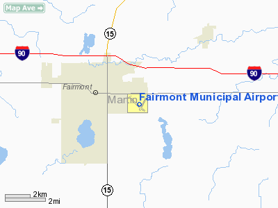
Fairmont Municipal Airport (IATA: FRM, ICAO: KFRM, FAA LID: FRM) is a city-owned public-use airport located two nautical miles (3.7 km) southeast of the central business district of Fairmont, a city in Martin County, Minnesota, United States.
Facilities and aircraft
Fairmont Municipal Airport covers an area of 229 acres (93 ha) at an elevation of 1,162 feet (354 m) above mean sea level. It has two asphalt paved runways: 13/31 is 5,505 by 100 feet (1,678 x 30 m) and 2/20 is 3,300 by 75 feet (1,006 x 23 m).
For the 12-month period ending May 30, 2008, the airport had 9,400 aircraft operations, an average of 25 per day: 91% general aviation, 7% air taxi and 1% military. At that time there were 30 aircraft based at this airport: 83% single-engine, 10% multi-engine, 3% jet and 3% ultralight.
The above content comes from Wikipedia and is published under free licenses – click here to read more.
Location & QuickFacts
| FAA Information Effective: | 2008-09-25 |
| Airport Identifier: | FRM |
| Airport Status: | Operational |
| Longitude/Latitude: | 094-24-56.2000W/43-38-38.2000N
-94.415611/43.643944 (Estimated) |
| Elevation: | 1162 ft / 354.18 m (Surveyed) |
| Land: | 229 acres |
| From nearest city: | 2 nautical miles SE of Fairmont, MN |
| Location: | Martin County, MN |
| Magnetic Variation: | 04E (1995) |
Owner & Manager
| Ownership: | Publicly owned |
| Owner: | City Of Fairmont |
| Address: | P.o. Box 751
Fairmont, MN 56031 |
| Phone number: | 507-238-9461 |
| Manager: | Alan Pelzer |
| Address: | 2159 East Blue Earth Ave
Fairmont, MN 56031 |
| Phone number: | 507-235-2537 |
Airport Operations and Facilities
| Airport Use: | Open to public |
| Wind indicator: | Yes |
| Segmented Circle: | Yes |
| Control Tower: | No |
| Lighting Schedule: | DUSK-DAWN
ACTVT MIRL RY 02/20 HIRL RY 13/31 VASI & REIL RY 13; VASI & MALSR RY 31 - 122.8 |
| Beacon Color: | Clear-Green (lighted land airport) |
| Landing fee charge: | No |
| Sectional chart: | Omaha |
| Region: | AGL - Great Lakes |
| Boundary ARTCC: | ZMP - Minneapolis |
| Tie-in FSS: | PNM - Princeton |
| FSS on Airport: | No |
| FSS Toll Free: | 1-800-WX-BRIEF |
| NOTAMs Facility: | FRM (NOTAM-d service avaliable) |
| Federal Agreements: | NGY |
Airport Communications
| CTAF: | 122.800 |
| Unicom: | 122.800 |
Airport Services
| Fuel available: | 100LLA
SELF SVC FUEL WITH CREDIT CARD. |
| Airframe Repair: | MINOR |
| Power Plant Repair: | MINOR |
| Bottled Oxygen: | NONE |
| Bulk Oxygen: | NONE |
Runway Information
Runway 02/20
| Dimension: | 3300 x 75 ft / 1005.8 x 22.9 m |
| Surface: | ASPH, Fair Condition |
| Weight Limit: | Single wheel: 12000 lbs. |
| Edge Lights: | Medium |
| |
Runway 02 |
Runway 20 |
| Longitude: | 094-24-54.5378W | 094-24-33.4211W |
| Latitude: | 43-38-23.0375N | 43-38-51.7931N |
| Elevation: | 1159.00 ft | 1158.00 ft |
| Alignment: | 28 | 127 |
| Traffic Pattern: | Left | Left |
| Markings: | Basic, Good Condition | Basic, Good Condition |
| Runway End Identifier: | No | No |
| Touchdown Lights: | No | No |
| Obstruction: | 17 ft road, 800.0 ft from runway, 175 ft right of centerline, 35:1 slope to clear | , 50:1 slope to clear |
|
Runway 13/31
| Dimension: | 5505 x 100 ft / 1677.9 x 30.5 m |
| Surface: | ASPH, Fair Condition |
| Surface Treatment: | Porous Friction Course |
| Weight Limit: | Single wheel: 35000 lbs.
Dual wheel: 40000 lbs. |
| Edge Lights: | High |
| |
Runway 13 |
Runway 31 |
| Longitude: | 094-25-30.4162W | 094-24-36.6821W |
| Latitude: | 43-38-57.5409N | 43-38-19.7159N |
| Elevation: | 1158.00 ft | 1160.00 ft |
| Alignment: | 127 | 127 |
| ILS Type: | | ILS
|
| Traffic Pattern: | Left | Left |
| Markings: | Precision instrument, Good Condition | Precision instrument, Good Condition |
| Crossing Height: | 48.00 ft | 46.00 ft |
| VASI: | 4-box on left side | 4-box on left side |
| Visual Glide Angle: | 3.00° | 3.00° |
| Approach lights: | | MALSR |
| Runway End Identifier: | Yes | No |
| Centerline Lights: | No | No |
| Touchdown Lights: | No | No |
| Obstruction: | 11 ft road, 400.0 ft from runway, 500 ft right of centerline, 18:1 slope to clear | , 50:1 slope to clear |
|
Radio Navigation Aids
| ID |
Type |
Name |
Ch |
Freq |
Var |
Dist |
| SBU | NDB | Blue Earth | | 332.00 | 04E | 14.2 nm |
| JYG | NDB | St James | | 260.00 | 04E | 21.4 nm |
| PUF | NDB | Puff | | 345.00 | 04E | 22.5 nm |
| MJQ | NDB | Jackson | | 353.00 | 04E | 24.8 nm |
| MWM | NDB | Windom | | 203.00 | 03E | 34.1 nm |
| AXA | NDB | Algona | | 403.00 | 03E | 34.4 nm |
| EGQ | NDB | Emmetsburg | | 410.00 | 04E | 35.0 nm |
| FXY | NDB | Forest City | | 359.00 | 05E | 42.5 nm |
| LTU | NDB | Little Sioux | | 326.00 | 05E | 44.1 nm |
| ACQ | NDB | Waseca | | 371.00 | 02E | 45.3 nm |
| ULM | NDB/DME | New Ulm | 050X | 272.00 | 04E | 40.7 nm |
| EST | VOR | Estherville | | 110.40 | 07E | 20.1 nm |
| FRM | VOR/DME | Fairmont | 039X | 110.20 | 07E | 0.3 nm |
| MKT | VOR/DME | Mankato | 045X | 110.80 | 07E | 40.9 nm |
| SPW | VOR/DME | Spencer | 037X | 110.00 | 05E | 44.9 nm |
| AEL | VOR/DME | Albert Lea | 035X | 109.80 | 05E | 45.5 nm |
Remarks
- MIGRATORY BIRD HAZARD SPRING & FALL; GULLS ON & INVOF ARPT.
Images and information placed above are from
http://www.airport-data.com/airport/FRM/
We thank them for the data!
| General Info
|
| Country |
United States
|
| State |
MINNESOTA
|
| FAA ID |
FRM
|
| Latitude |
43-38-38.188N
|
| Longitude |
094-24-56.216W
|
| Elevation |
1162 feet
|
| Near City |
FAIRMONT
|
We don't guarantee the information is fresh and accurate. The data may
be wrong or outdated.
For more up-to-date information please refer to other sources.
|
|


