 |
|
Coordinates: 47°49′28″N 091°49′51″W / 47.82444°N 91.83083°W / 47.82444; -91.83083
| Ely Municipal Airport |
| IATA: LYU – ICAO: KELO – FAA LID: ELO |
| Summary |
| Airport type |
Public |
| Owner |
City of Ely |
| Serves |
Ely, Minnesota |
| Elevation AMSL |
1,456 ft / 444 m |
| Runways |
| Direction |
Length |
Surface |
| ft |
m |
| 12/30 |
5,600 |
1,707 |
Asphalt |
| Statistics (2006) |
| Aircraft operations |
8,200 |
| Source: Federal Aviation Administration |
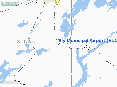
Ely Municipal Airport (IATA: LYU, ICAO: KELO, FAA LID: ELO) is a city-owned public-use airport located four miles (6 km) south of the central business district of Ely, a city in St. Louis County, Minnesota, United States.
Although most U.S. airports use the same three-letter location identifier for the FAA and IATA, Ely Municipal Airport is assigned ELO by the FAA and LYU by the IATA (which assigned ELO to Eldorado, Misiones, Argentina).
Facilities and aircraft
Ely Municipal Airport covers an area of 560 acres (227 ha) and contains one runway designated 12/30 with a 5,600 x 100 ft (1,707 x 30 m) asphalt surface. For the 12-month period ending April 30, 2006, the airport had 8,200 aircraft operations, an average of 22 per day: 98% general aviation and 2% air taxi.
The above content comes from Wikipedia and is published under free licenses – click here to read more.
Location & QuickFacts
| FAA Information Effective: | 2008-09-25 |
| Airport Identifier: | ELO |
| Airport Status: | Operational |
| Longitude/Latitude: | 091-49-50.6000W/47-49-28.4000N
-91.830722/47.824556 (Estimated) |
| Elevation: | 1456 ft / 443.79 m (Surveyed) |
| Land: | 560 acres |
| From nearest city: | 4 nautical miles S of Ely, MN |
| Location: | St Louis County, MN |
| Magnetic Variation: | 00E (2000) |
Owner & Manager
| Ownership: | Publicly owned |
| Owner: | City Of Ely |
| Address: | 209 East Chapman
Ely, MN 55731 |
| Phone number: | 218-365-3224 |
| Manager: | Jim Preblich |
| Address: | 1583 Hwy 1
Ely, MN 55731 |
| Phone number: | 218-365-5600 |
Airport Operations and Facilities
| Airport Use: | Open to public |
| Wind indicator: | Yes |
| Segmented Circle: | Yes |
| Control Tower: | No |
| Lighting Schedule: | DUSK-DAWN
MIRL RY 12/30 PRESET LOW INTST TO INCR INTST & ACTVT PAPI & REIL RYS 12 & 30 - CTAF. |
| Beacon Color: | Clear-Green (lighted land airport) |
| Landing fee charge: | No |
| Sectional chart: | Green Bay |
| Region: | AGL - Great Lakes |
| Boundary ARTCC: | ZMP - Minneapolis |
| Tie-in FSS: | PNM - Princeton |
| FSS on Airport: | No |
| FSS Toll Free: | 1-800-WX-BRIEF |
| NOTAMs Facility: | ELO (NOTAM-d service avaliable) |
| Federal Agreements: | NGSVY |
Airport Communications
| CTAF: | 122.800 |
| Unicom: | 122.800 |
Airport Services
| Fuel available: | 100LLA |
| Airframe Repair: | NONE |
| Power Plant Repair: | NONE |
| Bottled Oxygen: | NONE |
| Bulk Oxygen: | NONE |
Runway Information
Runway 12/30
| Dimension: | 5600 x 100 ft / 1706.9 x 30.5 m |
| Surface: | ASPH, Good Condition |
| Weight Limit: | Single wheel: 60000 lbs.
Dual wheel: 100000 lbs. |
| Edge Lights: | Medium |
| |
Runway 12 |
Runway 30 |
| Longitude: | 091-50-26.2461W | 091-49-14.9923W |
| Latitude: | 47-49-42.0921N | 47-49-14.6902N |
| Elevation: | 1441.00 ft | 1456.00 ft |
| Alignment: | 120 | 127 |
| Traffic Pattern: | Left | Left |
| Markings: | Non-precision instrument, Good Condition | Non-precision instrument, Good Condition |
| Crossing Height: | 59.00 ft | 52.00 ft |
| VASI: | 4-light PAPI on left side
PAPI OTS INDEFLY. | 4-light PAPI on left side
PAPI OTS INDEFLY. |
| Visual Glide Angle: | 3.00° | 3.00° |
| Runway End Identifier: | Yes
& 30 ARE OMNI-DIRECTIONAL. REIL OTS INDEFLY. | Yes
REIL OTS INDEFLY. |
| Obstruction: | 66 ft trees, 2200.0 ft from runway, 300 ft right of centerline, 30:1 slope to clear | 52 ft trees, 1370.0 ft from runway, 250 ft left of centerline, 22:1 slope to clear
TREES +23 FT 570 FT FM RY END 230 L, 16:1. |
|
Radio Navigation Aids
| ID |
Type |
Name |
Ch |
Freq |
Var |
Dist |
| CQM | NDB | Cook | | 233.00 | 01E | 34.7 nm |
| SCG | NDB | Scott | | 385.00 | 02E | 36.8 nm |
| BFW | NDB | Silver Bay | | 350.00 | 00E | 38.4 nm |
| ORB | NDB | Orr | | 341.00 | 02E | 43.1 nm |
| TWM | NDB | Two Harbors | | 243.00 | 01E | 46.6 nm |
| ELO | VOR/DME | Ely | 033X | 109.60 | 00E | 0.2 nm |
| EVM | VOR/DME | Eveleth | 019X | 108.20 | 01E | 36.3 nm |
| HIB | VOR/DME | Hibbing | 045X | 110.80 | 02E | 47.4 nm |
Images and information placed above are from
http://www.airport-data.com/airport/ELO/
We thank them for the data!
| General Info
|
| Country |
United States
|
| State |
MINNESOTA
|
| FAA ID |
ELO
|
| Latitude |
47-49-28.367N
|
| Longitude |
091-49-50.630W
|
| Elevation |
1455 feet
|
| Near City |
ELY
|
We don't guarantee the information is fresh and accurate. The data may
be wrong or outdated.
For more up-to-date information please refer to other sources.
|
|


