|
|
Duluth International Airport |
| Duluth International Airport |
 |
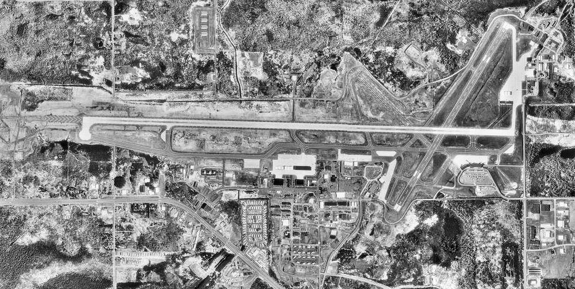
| USGS aerial image - 17 May 1991 |
| IATA: DLH – ICAO: KDLH – FAA LID: DLH |
| Summary |
| Airport type |
Public |
| Owner |
City of Duluth, Minn |
| Serves |
Duluth, Minnesota |
| Elevation AMSL |
1,428 ft / 435 m |
| Coordinates |
46°50′32″N 092°11′37″W / 46.84222°N 92.19361°W / 46.84222; -92.19361 |
| Website |
www.DuluthAirport.com |
| Runways |
| Direction |
Length |
Surface |
| ft |
m |
| 9/27 |
10,162 |
3,097 |
Concrete |
| 3/21 |
5,718 |
1,743 |
Asphalt |
| Statistics (2007) |
| Aircraft operations |
67,752 |
| Based aircraft |
86 |
| Sources: airport web site, FAA |
Duluth International Airport (IATA: DLH, ICAO: KDLH, FAA LID: DLH) is a city-owned, public-use airport located five nautical miles (9 km) northwest of the central business district of Duluth, a city in St. Louis County, Minnesota, United States. It serves the Duluth-Superior area including Superior, Wisconsin. It is mostly used for general aviation but is also served by three commercial airlines.
The Minnesota Air National Guard's 148th Fighter Wing, equipped with F-16C Fighting Falcons, is based at Duluth Air National Guard Base. History
The City of Duluth purchased the original property for the airport in 1929 from St. Louis County. The airport was constructed on 640 acres (2.6 km) of land with two 2,650-foot (810 m) sod runways. Subsequently, in 1930, the airfield was dedicated as a public airport. The airport was called the Williamson-Johnson Municipal Airport until 1963 at which time it was renamed Duluth International Airport.
In 1942, the three existing runways were paved. Each runway was 4,000 feet (1,200 m) long, 150 feet (46 m) wide, and at nearly equal angles from each other, 30, 90, and 130 degrees. They were identified as runways 3-21, 9-27, and 13-31 respectively. The Corps of Engineers extended runway 9-27 and Runway 3-21 to 5,699 feet (1,737 m) in 1945. In 1951 the USAF extended Runway 9-27 to 9,000 feet (2,700 m) with a 1,000-foot (300 m) overrun and the control tower was built. Runway 9-27 was completely rebuilt in 1956 and further extended in 1966 to 10,152 feet (3,094 m) in length.
The original terminal building was built in 1954, south of Runway 9-27, on the west side of Runway 3-21 and served the airport for nearly 20 years. The terminal floor area was 14,200 square feet (1,320 m) with 280 parking spaces.
In 1974, a new Terminal Building and U.S. Customs, International Arrivals Building, were completed east of Runway 13-31 and open for operation. Runway 13-31 was shortened to 2,578 feet (786 m) to accommodate construction of an addition to the International Arrivals building. This resulted in Runway 13-31 being closed as a runway due to obstructions. Runway 13-31 was subsequently re-striped in 1980, decreasing its width to 75 feet (23 m), for use as a taxiway only. In 1989, the new Terminal building and the adjacent structures were connected to form one enclosure. The original terminal building was then converted for use as offices for general aviation, the FAA, and the U.S. Weather Bureau.
Future
Future air service The Duluth Airport board is currently looking for possible carriers to serve Duluth International Airport. The most wanted new service is non-stop service to Chicago which took effect Dec. 17, 2009 by United Express. (American Airlines used to have Chicago O'Hare-Duluth service but had to stop this service because of flight restrictions at Chicago O'Hare Airport). The merger of Delta Air Lines and Northwest Airlines could result in non-stop service from Duluth to Atlanta, Cincinnati, or Salt Lake City.
New terminal A new terminal is being planned to replace the old terminal at the Duluth International Airport. The new terminal will be able to handle more people, flights, and airlines.
Facilities and aircraft
Duluth International Airport covers an area of 3,020 acres (1,222 ha) at an elevation of 1,428 feet (435 m) above mean sea level. It has two runways: 9/27 is 10,162 by 150 feet (3,097 x 46 m) with a concrete surface and 3/21 is 5,718 by 150 feet (1,743 x 46 m) with an asphalt surface.
For the 12-month period ending June 30, 2007, the airport had 67,752 aircraft operations, an average of 185 per day: 76% general aviation, 10% military, 8% air taxi, and 6% scheduled commercial. At that time there were 86 aircraft based at this airport: 60% single-engine, 13% multi-engine, 1% helicopter and 26% military.
Airlines and destinations
| Airlines |
Destinations |
| Allegiant Air |
Las Vegas, Orlando-Sanford |
| Delta Connection operated by Compass Airlines |
Minneapolis/St. Paul |
| Delta Connection operated by Pinnacle Airlines |
Detroit, Minneapolis/St. Paul |
| Delta Connection operated by SkyWest Airlines |
Minneapolis/St. Paul |
| United Express operated by SkyWest Airlines |
Chicago-O'Hare |
Cargo
- Bemidji Airlines (Minneapolis/St. Paul)
- FedEx Express
- FedEx Feeder operated by CSA Air (Rochester)
- FedEx Feeder operated by Mountain Air Cargo (Minneapolis/St. Paul)
The above content comes from Wikipedia and is published under free licenses – click here to read more.
|
 |
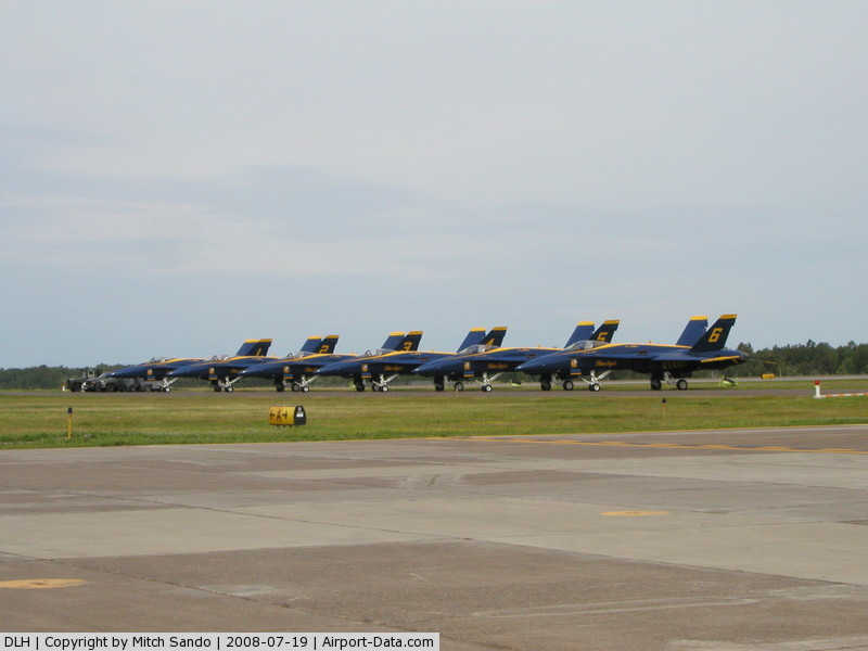
(Click on the photo to enlarge) |
Location & QuickFacts
| FAA Information Effective: | 2008-09-25 |
| Airport Identifier: | DLH |
| Airport Status: | Operational |
| Longitude/Latitude: | 092-11-37.1000W/46-50-31.5000N
-92.193639/46.842083 (Estimated) |
| Elevation: | 1428 ft / 435.25 m (Surveyed) |
| Land: | 3020 acres |
| From nearest city: | 5 nautical miles NW of Duluth, MN |
| Location: | St Louis County, MN |
| Magnetic Variation: | 02E (1985) |
Owner & Manager
| Ownership: | Publicly owned |
| Owner: | City Of Duluth, Minn |
| Address: | 4701 Grinden Dr
Duluth, MN 55811 |
| Phone number: | 218-727-2968 |
| Manager: | Brian D Ryks |
| Address: | 4701 Grinden Dr
Duluth, MN 55811 |
| Phone number: | 218-727-2968 |
Airport Operations and Facilities
| Airport Use: | Open to public |
| Wind indicator: | Yes |
| Segmented Circle: | No |
| Control Tower: | Yes |
| Lighting Schedule: | DUSK-DAWN |
| Beacon Color: | Clear-Green (lighted land airport) |
| Landing fee charge: | Yes
LNDG FEE FOR ALL COML ACFT & ALL ACFT OVR 10,000 LBS MAX LDG WEIGHT. |
| Sectional chart: | Green Bay |
| Region: | AGL - Great Lakes |
| Boundary ARTCC: | ZMP - Minneapolis |
| Tie-in FSS: | PNM - Princeton |
| FSS on Airport: | No |
| FSS Toll Free: | 1-800-WX-BRIEF |
| NOTAMs Facility: | DLH (NOTAM-d service avaliable) |
| Certification type/date: | I B S 05/1973 |
| Federal Agreements: | NGPY3 |
Airport Communications
Airport Services
| Fuel available: | 100LLA
J8 AVBL AT BOTH CIVILIAN & MILITARY FUELING FACILITIES. |
| Airframe Repair: | MAJOR |
| Power Plant Repair: | MAJOR |
| Bottled Oxygen: | HIGH/LOW |
| Bulk Oxygen: | HIGH/LOW |
Runway Information
Runway 03/21
| Dimension: | 5718 x 150 ft / 1742.8 x 45.7 m |
| Surface: | ASPH, Poor Condition
PAVEMENT IS IN POOR CONDITION WITH SURFACE DETERIORATION / CRACKING & POTENTIAL FOR DEBRIS THROUGHOUT. RY 09/27 APPEARS TO BE THE MOST AFFECTED AREA. RY 03/21 S OF RY 09/27 IS UNGROOVED IN SOME LOCATIONS. |
| Surface Treatment: | Saw-cut or plastic Grooved |
| Pavement Class: | 16 /F/C/X/T |
| Weight Limit: | Single wheel: 52000 lbs.
Dual wheel: 100000 lbs.
Dual tandem wheel: 361000 lbs. |
| Edge Lights: | High |
| |
Runway 03 |
Runway 21 |
| Longitude: | 092-11-17.7834W | 092-10-34.7233W |
| Latitude: | 46-50-08.6785N | 46-50-56.7668N |
| Elevation: | 1413.00 ft | 1416.00 ft |
| Alignment: | 32 | 127 |
| Traffic Pattern: | Left | Left |
| Markings: | Non-precision instrument, Fair Condition | Non-precision instrument, Fair Condition |
| Crossing Height: | 39.00 ft | 40.00 ft |
| VASI: | 4-light PAPI on left side | 4-box on left side |
| Visual Glide Angle: | 3.00° | 3.00° |
| Runway End Identifier: | Yes | Yes |
| Centerline Lights: | No | No |
| Touchdown Lights: | No | No |
| Obstruction: | 55 ft tree, 2100.0 ft from runway, 128 ft right of centerline, 34:1 slope to clear | , 50:1 slope to clear |
|
Runway 09/27
| Dimension: | 10162 x 150 ft / 3097.4 x 45.7 m |
| Surface: | CONC, Fair Condition
PAVEMENT IS IN POOR CONDITION WITH SURFACE DETERIORATION / CRACKING & POTENTIAL FOR DEBRIS THROUGHOUT. RY 09/27 APPEARS TO BE THE MOST AFFECTED AREA. RY 03/21 S OF RY 09/27 IS UNGROOVED IN SOME LOCATIONS. |
| Surface Treatment: | Saw-cut or plastic Grooved |
| Pavement Class: | 75 /R/C/W/U |
| Weight Limit: | Single wheel: 94000 lbs.
Dual wheel: 180000 lbs.
Dual tandem wheel: 650000 lbs. |
| Edge Lights: | High |
| |
Runway 09 |
Runway 27 |
| Longitude: | 092-13-13.0437W | 092-10-46.9889W |
| Latitude: | 46-50-32.8439N | 46-50-28.8694N |
| Elevation: | 1428.00 ft | 1419.00 ft |
| Alignment: | 92 | 127 |
| ILS Type: | ILS
| ILS
|
| Traffic Pattern: | Left | Left |
| Markings: | Precision instrument, Good Condition | Precision instrument, Good Condition |
| Arresting: | BAK12 | BAK12 |
| Crossing Height: | 50.00 ft | 96.00 ft |
| VASI: | 4-light PAPI on left side | 4-light PAPI on left side |
| Visual Glide Angle: | 3.00° | 3.00° |
| RVR Equipment: | touchdown | touchdown |
| Approach lights: | ALSF2 | MALSR |
| Runway End Identifier: | No | No |
| Centerline Lights: | Yes | Yes |
| Touchdown Lights: | Yes | Yes |
| Obstruction: | 57 ft tree, 2795.0 ft from runway, 252 ft left of centerline, 45:1 slope to clear | , 50:1 slope to clear |
|
Radio Navigation Aids
| ID |
Type |
Name |
Ch |
Freq |
Var |
Dist |
| DL | NDB | Pykla | | 379.00 | 02E | 6.6 nm |
| SUW | NDB | Bong | | 260.00 | 01E | 9.8 nm |
| COQ | NDB | Cloquet | | 335.00 | 03E | 15.4 nm |
| TWM | NDB | Two Harbors | | 243.00 | 01E | 22.3 nm |
| OLG | NDB | Solon Springs | | 388.00 | 01E | 35.2 nm |
| MZH | NDB | Moose Lake | | 362.00 | 02E | 35.9 nm |
| BFW | NDB | Silver Bay | | 350.00 | 00E | 40.3 nm |
| LKI | TACAN | Lakeside | 011X | | 05E | 0.4 nm |
| HIB | VOR/DME | Hibbing | 045X | 110.80 | 02E | 34.6 nm |
| EVM | VOR/DME | Eveleth | 019X | 108.20 | 01E | 37.0 nm |
| DLH | VORTAC | Duluth | 073X | 112.60 | 05E | 2.4 nm |
Remarks
- DEER AND BIRDS ON & INVOF ARPT.
- BEARING STRENGTH RWY 03-21 & 09-27: RWY 03-21 - ST127, RWY 09/27 ST153.
- JASU: 9(AM32A-60) 2(A/M32A-86) 2(MC-11) 6(MC-2A) (MIL).
- FLUID: SP LOX LHNIT (MIL), SP DE-ICE LHOX LHNIT (MONACO AIR DULUTH).
- OIL: O-148(MIL). JOAP.
- CAUTION: WINDSHEAR/DOWNDRAFTS FINAL APCH RWY 27.
- ANG - OPR 1200Z-2130Z++M-F EXEC HOL. LTD OPR HR AND TRAN SVC AVBL. CTC COMD POST DSN 825-7370/71, C218-788-7370/71. TRAN ACFT MAY NOT BE SVC WHEN WIND CHILL EXCEEDS OR IS FCST TO EXCEED -30 F. FOR RCR INFO, AFLD STATUS AND CRASH RESCUE CAPABILITY CTC COMD POST OR TWR.
- ANG: IF MIL ACFT WILL BE LANDING AND RQR CSTMS SVC AND ANG RAMP IS CLSD, ACFT WILL PARK ON THE CSTMS RAMP.
- BAK 14 A-GEAR LCTD 1500'FM AER 09 & 2250'FM AER 27.
- CAUTION: BIRD HAZ. (PHASE II CONDITIONS) EXISTS DUR 1 SEP THRU 31 OCT. CTC SOF/COMD POST FOR INFO.
- TRAN ACFT SVCS AVBL CONTINUOUSLY C218-727-2911.
- MILITARY SERVICE: FUEL J8(MIL), 100LL, JET A, (TRAN ACFT SVCS AVBL CONTINUOUSLY-MONACO AIR DULUTH, CALL C218-727-2911).
- TWY 'B' NOW NON-MOVEMENT AREA.
- TWY 'A4' CLSD INDEFLY.
- HIGH SPEED MIL JET TFC AT 3000'TO 3300' MSL IN AREA.
- WHEN RY 03/21 IS IN USE TWY C NORTH OF RY 09/27 MAY BE RESTRICTED BY ATC TO ACFT WITH WINGSPANS LESS THAN 49 FT.
- TWY 'C' SOUTH OF TWY 'A' CLSD WINTER MONTHS.
Images and information placed above are from
http://www.airport-data.com/airport/DLH/
We thank them for the data!
| General Info
|
| Country |
United States
|
| State |
MINNESOTA
|
| FAA ID |
DLH
|
| Latitude |
46-50-31.525N
|
| Longitude |
092-11-37.135W
|
| Elevation |
1428 feet
|
| Near City |
DULUTH
|
We don't guarantee the information is fresh and accurate. The data may
be wrong or outdated.
For more up-to-date information please refer to other sources.
|
|