 |
|
Crookston Municipal Kirkwood Fld Airport |
Crookston Municipal Airport
Kirkwood Field |
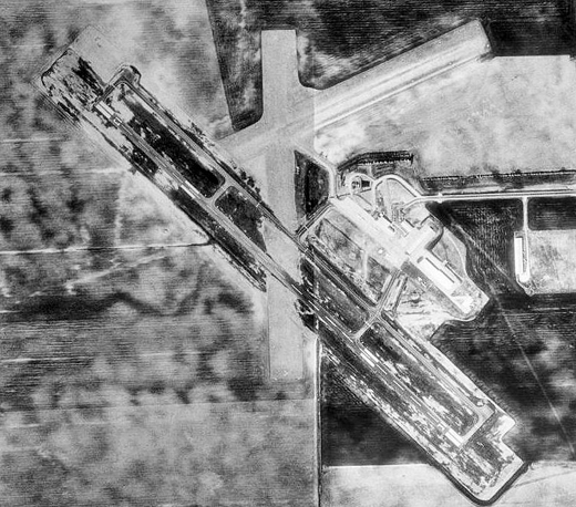 |
| 1991 USGS Photo |
| IATA: CKN – ICAO: KCKN – FAA LID: CKN |
| Summary |
| Airport type |
Public |
| Owner |
City of Crookston |
| Serves |
Crookston, Minnesota |
| Location |
Lowell Township, Polk County, near Crookston, Minnesota |
| Elevation AMSL |
899 ft / 274 m |
| Coordinates |
47°50′27″N 096°37′18″W / 47.84083°N 96.62167°W / 47.84083; -96.62167 |
| Runways |
| Direction |
Length |
Surface |
| ft |
m |
| 13/31 |
4,300 |
1,311 |
Asphalt |
| 17/35 |
2,977 |
907 |
Turf |
| 6/24 |
2,096 |
639 |
Turf |
| Statistics (2006) |
| Aircraft operations |
20,150 |
| Based aircraft |
38 |
| Source: Federal Aviation Administration |
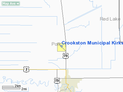
Crookston Municipal Airport (IATA: CKN, ICAO: KCKN, FAA LID: CKN), also known as Kirkwood Field, is a city-owned public-use airport located four nautical miles (7 km) north of the central business district of Crookston, a city in Polk County, Minnesota, United States. History
Provided contract glider training to the United States Army Air Forces, 1942-1944. Training provided by L. Millar-Wittig. Had turf 5,000' all-way airfield for landings and takeoffs. Used primarily C-47 Skytrains and Waco CG-4 unpowered Gliders. The mission of the school was to train glider pilot students in proficiency in operation of gliders in various types of towed and soaring flight, both day and night, and in servicing of gliders in the field.
Facilities and aircraft
Crookston Municipal Airport covers an area of 633 acres (256 ha) at an elevation of 899 feet (274 m) above mean sea level. It has three runways: 13/31 is 4,300 by 75 feet (1,311 x 23 m) with an asphalt surface; 17/35 is 2,977 by 202 feet (907 x 62 m) with an turf surface; 6/24 is 2,096 by 202 feet (639 x 62 m) with a turf surface.
For the 12-month period ending August 31, 2006, the airport had 20,150 aircraft operations, an average of 55 per day: 94% general aviation, 5% air taxi and <1% military. At that time there were 38 aircraft based at this airport: 97% single-engine and 3% multi-engine.
The above content comes from Wikipedia and is published under free licenses – click here to read more.
Location & QuickFacts
| FAA Information Effective: | 2008-09-25 |
| Airport Identifier: | CKN |
| Airport Status: | Operational |
| Longitude/Latitude: | 096-37-17.2330W/47-50-29.9650N
-96.621454/47.841657 (Estimated) |
| Elevation: | 899 ft / 274.02 m (Surveyed) |
| Land: | 633 acres |
| From nearest city: | 4 nautical miles N of Crookston, MN |
| Location: | Polk County, MN |
| Magnetic Variation: | 07E (1980) |
Owner & Manager
| Ownership: | Publicly owned |
| Owner: | City Of Crookston |
| Address: | 124 N Broadway
Crookston, MN 56716 |
| Phone number: | 218-281-4503 |
| Manager: | Lowell Miller |
| Address: | 26305 Airport Road Sw
Crookston, MN 56716 |
| Phone number: | 218-281-2625 |
Airport Operations and Facilities
| Airport Use: | Open to public |
| Wind indicator: | Yes |
| Segmented Circle: | No |
| Control Tower: | No |
| Lighting Schedule: | DUSK-DAWN
ACTVT MIRL RY 13/31, REILS RY 13 & RY 31 & PAPI RY 13 & RY 31 - CTAF. |
| Beacon Color: | Clear-Green (lighted land airport) |
| Landing fee charge: | No |
| Sectional chart: | Twin Cities |
| Region: | AGL - Great Lakes |
| Traffic Pattern Alt: | 800 ft |
| Boundary ARTCC: | ZMP - Minneapolis |
| Tie-in FSS: | PNM - Princeton |
| FSS on Airport: | No |
| FSS Toll Free: | 1-800-WX-BRIEF |
| NOTAMs Facility: | CKN (NOTAM-d service avaliable) |
| Federal Agreements: | NY1 |
Airport Communications
| CTAF: | 122.700 |
| Unicom: | 122.700 |
Airport Services
| Fuel available: | 100LLA MOGAS
FUEL AVAIL 24 HRS W CREDIT CARD. |
| Airframe Repair: | MAJOR |
| Power Plant Repair: | MAJOR |
| Bottled Oxygen: | NONE |
| Bulk Oxygen: | NONE |
Runway Information
Runway 06/24
| Dimension: | 2096 x 202 ft / 638.9 x 61.6 m |
| Surface: | TURF, Good Condition |
| |
Runway 06 |
Runway 24 |
| Longitude: | 096-37-21.9114W | 096-36-53.6456W |
| Latitude: | 47-50-36.1983N | 47-50-44.3022N |
| Elevation: | 893.00 ft | 900.00 ft |
| Alignment: | 67 | 127 |
| Traffic Pattern: | Left | Left |
| Obstruction: | , 50:1 slope to clear | 55 ft trees, 1100.0 ft from runway, 200 ft right of centerline, 20:1 slope to clear |
|
Runway 13/31
| Dimension: | 4300 x 75 ft / 1310.6 x 22.9 m |
| Surface: | ASPH, Good Condition |
| Weight Limit: | Single wheel: 11000 lbs.
Dual wheel: 16000 lbs. |
| Edge Lights: | Medium |
| |
Runway 13 |
Runway 31 |
| Longitude: | 096-37-42.4473W | 096-36-57.8435W |
| Latitude: | 47-50-39.6546N | 47-50-09.6701N |
| Elevation: | 894.00 ft | 896.00 ft |
| Alignment: | 127 | 127 |
| Traffic Pattern: | Left | Left |
| Markings: | Non-precision instrument, Good Condition | Non-precision instrument, Good Condition |
| VASI: | 4-light PAPI on left side | 4-light PAPI on right side |
| Runway End Identifier: | Yes | Yes |
| Obstruction: | , 50:1 slope to clear | 27 ft pline, 1300.0 ft from runway, 400 ft right of centerline, 40:1 slope to clear |
|
Runway 17/35
| Dimension: | 2977 x 202 ft / 907.4 x 61.6 m |
| Surface: | TURF, Good Condition |
| |
Runway 17 |
Runway 35 |
| Longitude: | 096-37-19.7440W | 096-37-19.6211W |
| Latitude: | 47-50-45.0712N | 47-50-15.6977N |
| Elevation: | 895.00 ft | 892.00 ft |
| Alignment: | 127 | 127 |
| Traffic Pattern: | Left | Left |
| Obstruction: | 18 ft road, 500.0 ft from runway, 27:1 slope to clear | , 50:1 slope to clear |
|
Radio Navigation Aids
| ID |
Type |
Name |
Ch |
Freq |
Var |
Dist |
| CKN | NDB | Crookston | | 400.00 | 07E | 0.3 nm |
| FSE | NDB | Fosston | | 224.00 | 05E | 37.6 nm |
| RDR | TACAN | Red River | 111X | | 06E | 32.4 nm |
| TVF | VOR/DME | Thief River Falls | 021X | 108.40 | 08E | 22.2 nm |
| GFK | VOR/DME | Grand Forks | 090X | 114.30 | 09E | 23.7 nm |
Remarks
- RY 17/35 AND 06/24 CLSD WINTER MONTHS.
Images and information placed above are from
http://www.airport-data.com/airport/CKN/
We thank them for the data!
| General Info
|
| Country |
United States
|
| State |
MINNESOTA
|
| FAA ID |
CKN
|
| Latitude |
47-50-30.099N
|
| Longitude |
096-37-17.833W
|
| Elevation |
899 feet
|
| Near City |
CROOKSTON
|
We don't guarantee the information is fresh and accurate. The data may
be wrong or outdated.
For more up-to-date information please refer to other sources.
|
|


