 |
|
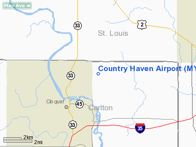
Location & QuickFacts
| FAA Information Effective: | 2008-09-25 |
| Airport Identifier: | MY94 |
| Airport Status: | Operational |
| Longitude/Latitude: | 092-25-09.0000W/46-45-09.0000N
-92.419167/46.752500 (Estimated) |
| Elevation: | 1309 ft / 398.98 m (Estimated) |
| Land: | 0 acres |
| From nearest city: | 2 nautical miles NE of Cloquet, MN |
| Location: | Carlton County, MN |
| Magnetic Variation: | 02E (1990) |
Owner & Manager
| Ownership: | Privately owned |
| Owner: | Dale Burgess |
| Address: | 255 West Stark Road
Cloquet, MN 55720 |
| Phone number: | 218-879-6559 |
| Manager: | Dale Burgess |
| Address: | 255 West Stark Road
Cloquet, MN 55720 |
| Phone number: | 218-879-6559 |
Airport Operations and Facilities
| Airport Use: | Private
PERSONAL USE. |
| Segmented Circle: | No |
| Control Tower: | No |
| Sectional chart: | Green Bay |
| Region: | AGL - Great Lakes |
| Boundary ARTCC: | ZMP - Minneapolis |
| Tie-in FSS: | PNM - Princeton |
| FSS on Airport: | No |
| FSS Toll Free: | 1-800-WX-BRIEF |
Runway Information
Runway 09/27
| Dimension: | 1200 x 50 ft / 365.8 x 15.2 m |
| Surface: | TURF, |
| |
Runway 09 |
Runway 27 |
| Traffic Pattern: | Left | Left |
| Obstruction: | 50 ft pline, 660.0 ft from runway | |
|
Radio Navigation Aids
| ID |
Type |
Name |
Ch |
Freq |
Var |
Dist |
| COQ | NDB | Cloquet | | 335.00 | 03E | 4.8 nm |
| DL | NDB | Pykla | | 379.00 | 02E | 6.2 nm |
| SUW | NDB | Bong | | 260.00 | 01E | 13.5 nm |
| MZH | NDB | Moose Lake | | 362.00 | 02E | 25.7 nm |
| TWM | NDB | Two Harbors | | 243.00 | 01E | 33.0 nm |
| OLG | NDB | Solon Springs | | 388.00 | 01E | 36.2 nm |
| LKI | TACAN | Lakeside | 011X | | 05E | 11.1 nm |
| HIB | VOR/DME | Hibbing | 045X | 110.80 | 02E | 35.0 nm |
| EVM | VOR/DME | Eveleth | 019X | 108.20 | 01E | 40.4 nm |
| DLH | VORTAC | Duluth | 073X | 112.60 | 05E | 9.4 nm |
Remarks
- PRVDD ANY OBSTNS IN RY APCH SLOPE BE LOWERED OR REMOVED & AREA 125 FT EITHER SIDE OF RY CNTRLN AND 300 FT OFF EITHER END BE CLEAR OF ANY OBSTNS.
Images and information placed above are from
http://www.airport-data.com/airport/MY94/
We thank them for the data!
| General Info
|
| Country |
United States
|
| State |
MINNESOTA
|
| FAA ID |
MY94
|
| Latitude |
46-45-09.000N
|
| Longitude |
092-25-09.000W
|
| Elevation |
1309 feet
|
| Near City |
CLOQUET
|
We don't guarantee the information is fresh and accurate. The data may
be wrong or outdated.
For more up-to-date information please refer to other sources.
|
|


