 |
|
Cloquet Carlton County Airport |
| Cloquet Carlton County Airport |
| IATA: none – ICAO: KCOQ – FAA LID: COQ |
| Summary |
| Airport type |
Public |
| Owner |
Carlton County |
| Serves |
Cloquet, Minnesota |
| Elevation AMSL |
1,279 ft / 390 m |
| Coordinates |
46°42′04″N 092°30′13″W / 46.70111°N 92.50361°W / 46.70111; -92.50361 |
| Website |
CloquetAirport.com |
| Runways |
| Direction |
Length |
Surface |
| ft |
m |
| 17/35 |
4,003 |
1,220 |
Asphalt |
| 7/25 |
3,100 |
945 |
Asphalt |
| Statistics (2005) |
| Aircraft operations |
10,000 |
| Based aircraft |
51 |
| Source: Federal Aviation Administration |
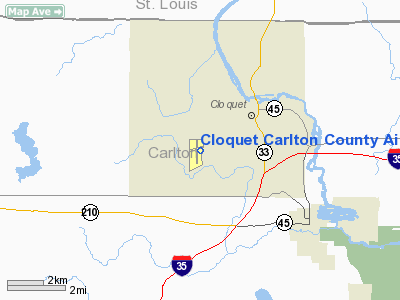
Cloquet Carlton County Airport (ICAO: KCOQ, FAA LID: COQ) is a county-owned public-use airport located three nautical miles (6 km) southwest of the central business district of Cloquet, a city in Carlton County, Minnesota, United States.
Although most U.S. airports use the same three-letter location identifier for the FAA and IATA, this airport is assigned COQ by the FAA but has no designation from the IATA (which assigned COQ to Choibalsan Airport in Choibalsan, Mongolia).
Facilities and aircraft
Cloquet Carlton County Airport covers an area of 233 acres (94 ha) at an elevation of 1,279 feet (390 m) above mean sea level. It has two asphalt paved runways: 17/35 is 4,003 by 75 feet (1,220 x 23 m) and 7/25 is 3,100 by 75 feet (945 x 23 m).
For the 12-month period ending April 30, 2005, the airport had 10,000 aircraft operations, an average of 27 per day: 99% general aviation and 1% military. At that time there were 51 aircraft based at this airport: 98% single-engine and 2% ultralight.
Airport taxi service is available for city. Phone number is 218 591 2900
The above content comes from Wikipedia and is published under free licenses – click here to read more.
Location & QuickFacts
| FAA Information Effective: | 2008-09-25 |
| Airport Identifier: | COQ |
| Airport Status: | Operational |
| Longitude/Latitude: | 092-30-12.9800W/46-42-04.0800N
-92.503606/46.701133 (Estimated) |
| Elevation: | 1279 ft / 389.84 m (Surveyed) |
| Land: | 233 acres |
| From nearest city: | 3 nautical miles SW of Cloquet, MN |
| Location: | Carlton County, MN |
| Magnetic Variation: | 03E (1980) |
Owner & Manager
| Ownership: | Publicly owned |
| Owner: | Carlton County |
| Address: | Carlton County Courthouse
Carlton, MN 55718 |
| Phone number: | 218-384-9151 |
| Manager: | Quinten Anderson |
| Address: | 125 Wheaton Road
Cloquet, MN 55720 |
| Phone number: | 218-879-4911 |
Airport Operations and Facilities
| Airport Use: | Open to public |
| Wind indicator: | Yes |
| Segmented Circle: | No |
| Control Tower: | No |
| Lighting Schedule: | DUSK-DAWN
ACTVT MIRL RYS 07/25 & 17/35, ODALS RY 35 & REIL RY 17, VASI RYS 17 & 35 - CTAF. |
| Beacon Color: | Clear-Green (lighted land airport) |
| Landing fee charge: | No |
| Sectional chart: | Green Bay |
| Region: | AGL - Great Lakes |
| Boundary ARTCC: | ZMP - Minneapolis |
| Tie-in FSS: | PNM - Princeton |
| FSS on Airport: | No |
| FSS Toll Free: | 1-800-WX-BRIEF |
| NOTAMs Facility: | COQ (NOTAM-d service avaliable) |
| Federal Agreements: | NGY |
Airport Communications
| CTAF: | 122.800 |
| Unicom: | 122.800 |
Airport Services
| Fuel available: | 100LLA |
| Airframe Repair: | MAJOR |
| Power Plant Repair: | MAJOR |
| Bottled Oxygen: | NONE |
| Bulk Oxygen: | NONE |
Runway Information
Runway 07/25
| Dimension: | 3100 x 75 ft / 944.9 x 22.9 m |
| Surface: | ASPH, Good Condition |
| Edge Lights: | Medium |
| |
Runway 07 |
Runway 25 |
| Longitude: | 092-30-25.2900W | 092-29-42.7800W |
| Latitude: | 46-42-04.0700N | 46-42-13.0700N |
| Elevation: | 1276.00 ft | 1266.00 ft |
| Alignment: | 73 | 127 |
| Traffic Pattern: | Left | Left |
| Markings: | Non-precision instrument, Good Condition | Non-precision instrument, Good Condition |
| Obstruction: | 105 ft trees, 2300.0 ft from runway, 20:1 slope to clear | 48 ft trees, 1900.0 ft from runway, 35:1 slope to clear |
|
Runway 17/35
| Dimension: | 4003 x 75 ft / 1220.1 x 22.9 m |
| Surface: | ASPH, Good Condition |
| Weight Limit: | Single wheel: 8000 lbs.
Dual wheel: 12000 lbs. |
| Edge Lights: | Medium |
| |
Runway 17 |
Runway 35 |
| Longitude: | 092-30-20.3050W | 092-30-19.5010W |
| Latitude: | 46-42-20.3570N | 46-41-40.8550N |
| Elevation: | 1278.00 ft | 1272.00 ft |
| Alignment: | 127 | 127 |
| Traffic Pattern: | Left | Left |
| Markings: | Non-precision instrument, Good Condition | Non-precision instrument, Good Condition |
| Crossing Height: | 29.00 ft | 0.00 ft |
| VASI: | 4-box on left side | 4-box on left side |
| Visual Glide Angle: | 3.00° | 0.00° |
| Approach lights: | | ODALS |
| Runway End Identifier: | Yes | |
| Obstruction: | 70 ft trees, 2200.0 ft from runway, 50 ft left of centerline, 31:1 slope to clear | 19 ft , 963.0 ft from runway, 250 ft right of centerline, 40:1 slope to clear
A058 RWY 35, +10 FT TREE, 150 FT FROM RWY END, 40 FT R |
|
Radio Navigation Aids
| ID |
Type |
Name |
Ch |
Freq |
Var |
Dist |
| COQ | NDB | Cloquet | | 335.00 | 03E | 0.2 nm |
| DL | NDB | Pykla | | 379.00 | 02E | 10.6 nm |
| SUW | NDB | Bong | | 260.00 | 01E | 16.5 nm |
| MZH | NDB | Moose Lake | | 362.00 | 02E | 21.2 nm |
| OLG | NDB | Solon Springs | | 388.00 | 01E | 36.7 nm |
| TWM | NDB | Two Harbors | | 243.00 | 01E | 37.7 nm |
| AIT | NDB | Aitkin | | 397.00 | 03E | 49.2 nm |
| LKI | TACAN | Lakeside | 011X | | 05E | 15.7 nm |
| HIB | VOR/DME | Hibbing | 045X | 110.80 | 02E | 37.0 nm |
| EVM | VOR/DME | Eveleth | 019X | 108.20 | 01E | 43.3 nm |
| GPZ | VOR/DME | Grand Rapids | 051X | 111.40 | 06E | 49.1 nm |
| DLH | VORTAC | Duluth | 073X | 112.60 | 05E | 13.8 nm |
Images and information placed above are from
http://www.airport-data.com/airport/COQ/
We thank them for the data!
| General Info
|
| Country |
United States
|
| State |
MINNESOTA
|
| FAA ID |
COQ
|
| Latitude |
46-42-04.080N
|
| Longitude |
092-30-12.980W
|
| Elevation |
1279 feet
|
| Near City |
CLOQUET
|
We don't guarantee the information is fresh and accurate. The data may
be wrong or outdated.
For more up-to-date information please refer to other sources.
|
|


