 |
|
| Range Regional Airport |
| IATA: HIB – ICAO: KHIB – FAA LID: HIB |
| Summary |
| Airport type |
Public |
| Owner |
Chisholm/Hibbing Airport Authority |
| Serves |
Hibbing, Minnesota |
| Elevation AMSL |
1,354 ft / 413 m |
| Coordinates |
47°23′12″N 092°50′20″W / 47.38667°N 92.83889°W / 47.38667; -92.83889 |
| Website |
RangeRegionalAirport.com |
| Runways |
| Direction |
Length |
Surface |
| ft |
m |
| 13/31 |
6,760 |
2,060 |
Asphalt |
| 4/22 |
3,096 |
944 |
Asphalt |
| Statistics (2009) |
| Aircraft operations |
30,365 |
| Based aircraft |
52 |
| Source: Federal Aviation Administration |
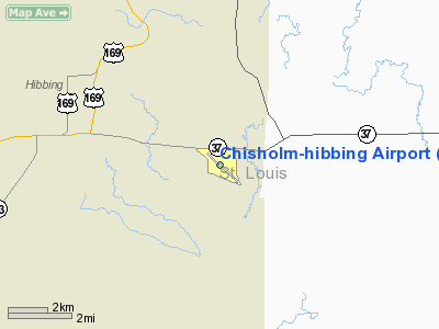
Range Regional Airport (IATA: HIB, ICAO: KHIB, FAA LID: HIB) is a public use airport located four nautical miles (7 km) southeast of the central business district of Hibbing, a city in St. Louis County, Minnesota, United States. It was formerly known as Chisholm-Hibbing Airport or Chisholm-Hibbing Municipal Airport. The airport is mostly used for general aviation but is also served by one commercial and one charter airline. Service is subsidized by the Essential Air Service program. Facilities and aircraft
Range Regional Airport covers an area of 1,600 acres (647 ha) at an elevation of 1,354 feet (413 m) above mean sea level. It has two asphalt paved runways: 13/31 is 6,760 by 150 feet (2,060 x 46 m) and 4/22 is 3,096 by 75 feet (944 x 23 m).
For the 12-month period ending August 31, 2009, the airport had 30,365 aircraft operations, an average of 83 per day: 82% general aviation, 9% scheduled commercial, 9% air taxi, and <1% military. At that time there were 52 aircraft based at this airport: 77% single-engine, 4% multi-engine and 19% helicopter.
Airline and scheduled destinations
| Airlines |
Destinations |
| Delta Connection operated by Mesaba Airlines |
Thief River Falls, Minneapolis/St.Paul |
Charter airline
| Airlines |
Destinations |
| Sun Country |
Laughlin, Nevada |
Incidents
On December 1, 1993, Northwest Airlink Flight 5719, crashed while on approach to Range Regional Airport. All 18 passengers and crew on board were killed.
The above content comes from Wikipedia and is published under free licenses – click here to read more.
Location & QuickFacts
| FAA Information Effective: | 2008-09-25 |
| Airport Identifier: | HIB |
| Airport Status: | Operational |
| Longitude/Latitude: | 092-50-20.3760W/47-23-11.7570N
-92.838993/47.386599 (Estimated) |
| Elevation: | 1353 ft / 412.39 m (Surveyed) |
| Land: | 1600 acres |
| From nearest city: | 4 nautical miles SE of Hibbing, MN |
| Location: | St Louis County, MN |
| Magnetic Variation: | 02E (1995) |
Owner & Manager
| Ownership: | Publicly owned |
| Owner: | Chisholm-hibbing Airport |
| Address: | 11038 E. Hwy 37
Hibbing, MN 55746 |
| Phone number: | 218-262-3451 |
| Manager: | David Danielson |
| Address: | Chisholb-hibbing Airport, 11038 E. Hwy 37
Hibbing, MN 55746 |
| Phone number: | 218-262-3451 |
Airport Operations and Facilities
| Airport Use: | Open to public |
| Wind indicator: | Yes |
| Segmented Circle: | Yes |
| Control Tower: | No |
| Lighting Schedule: | DUSK-DAWN
HIRL RY 13/31 PRESET LOW INTST; TO INCR INTST & ACTVT VASI & MALSR RYS 13 & 31- CTAF. |
| Beacon Color: | Clear-Green (lighted land airport) |
| Landing fee charge: | No |
| Sectional chart: | Green Bay |
| Region: | AGL - Great Lakes |
| Boundary ARTCC: | ZMP - Minneapolis |
| Tie-in FSS: | PNM - Princeton |
| FSS on Airport: | No |
| FSS Toll Free: | 1-800-WX-BRIEF |
| NOTAMs Facility: | HIB (NOTAM-d service avaliable) |
| Certification type/date: | I A S 06/1973
PPR FOR UNSKED ACR OPNS WITH MORE THAN 30 PSGR SEATS CALL AMGR 218-262-3451. RY 04/22 NOT AVBL FOR ACR OPNS WITH MORE THAN 9 PSGR SEATS. |
| Federal Agreements: | NGY3 |
Airport Communications
| CTAF: | 123.000 |
| Unicom: | 123.000 |
Airport Services
| Fuel available: | 100LLA |
| Airframe Repair: | MAJOR |
| Power Plant Repair: | MAJOR |
| Bottled Oxygen: | NONE |
| Bulk Oxygen: | NONE |
Runway Information
Runway 04/22
| Dimension: | 3075 x 75 ft / 937.3 x 22.9 m |
| Surface: | ASPH, Fair Condition |
| Weight Limit: | Single wheel: 35000 lbs.
Dual wheel: 45000 lbs. |
| |
Runway 04 |
Runway 22 |
| Longitude: | 092-50-47.7020W | 092-50-13.7940W |
| Latitude: | 47-23-10.7730N | 47-23-30.5380N |
| Elevation: | 1348.00 ft | 1350.00 ft |
| Alignment: | 49 | 127 |
| Traffic Pattern: | Left | Left |
| Markings: | Basic, Fair Condition | Basic, Fair Condition |
| Runway End Identifier: | No | No |
| Centerline Lights: | No | No |
| Touchdown Lights: | No | No |
| Obstruction: | 11 ft road, 430.0 ft from runway, 150 ft right of centerline, 21:1 slope to clear | , 50:1 slope to clear |
|
Runway 13/31
| Dimension: | 6758 x 150 ft / 2059.8 x 45.7 m |
| Surface: | ASPH, Fair Condition |
| Surface Treatment: | Saw-cut or plastic Grooved |
| Weight Limit: | Single wheel: 60000 lbs.
Dual wheel: 100000 lbs.
Dual tandem wheel: 160000 lbs. |
| Edge Lights: | High |
| |
Runway 13 |
Runway 31 |
| Longitude: | 092-50-52.0410W | 092-49-39.3220W |
| Latitude: | 47-23-30.0540N | 47-22-45.2330N |
| Elevation: | 1353.00 ft | 1337.00 ft |
| Alignment: | 127 | 127 |
| ILS Type: | ILS
| ILS
|
| Traffic Pattern: | Left | Left |
| Markings: | Precision instrument, Fair Condition | Precision instrument, Fair Condition |
| Crossing Height: | 45.00 ft | 57.00 ft |
| VASI: | 4-box on left side | 4-box on left side |
| Visual Glide Angle: | 3.00° | 2.90° |
| Approach lights: | MALSR | MALSR |
| Runway End Identifier: | No | No |
| Centerline Lights: | No | No |
| Touchdown Lights: | No | No |
| Obstruction: | 16 ft road, 750.0 ft from runway, 500 ft left of centerline, 34:1 slope to clear | 83 ft trees, 3890.0 ft from runway, 640 ft left of centerline, 44:1 slope to clear |
|
Radio Navigation Aids
| ID |
Type |
Name |
Ch |
Freq |
Var |
Dist |
| CQM | NDB | Cook | | 233.00 | 01E | 26.8 nm |
| ORB | NDB | Orr | | 341.00 | 02E | 38.0 nm |
| DL | NDB | Pykla | | 379.00 | 02E | 38.1 nm |
| FOZ | NDB | Bigfork | | 345.00 | 02E | 40.8 nm |
| COQ | NDB | Cloquet | | 335.00 | 03E | 43.7 nm |
| TWM | NDB | Two Harbors | | 243.00 | 01E | 49.0 nm |
| LKI | TACAN | Lakeside | 011X | | 05E | 42.1 nm |
| HIB | VOR/DME | Hibbing | 045X | 110.80 | 02E | 7.5 nm |
| EVM | VOR/DME | Eveleth | 019X | 108.20 | 01E | 14.0 nm |
| GPZ | VOR/DME | Grand Rapids | 051X | 111.40 | 06E | 29.7 nm |
| ELO | VOR/DME | Ely | 033X | 109.60 | 00E | 48.5 nm |
| DLH | VORTAC | Duluth | 073X | 112.60 | 05E | 43.7 nm |
Remarks
- CTC DULUTH APP CON TO ACTVT RYS 13 & 31 ILS 0600-2300.
Images and information placed above are from
http://www.airport-data.com/airport/HIB/
We thank them for the data!
| General Info
|
| Country |
United States
|
| State |
MINNESOTA
|
| FAA ID |
HIB
|
| Latitude |
47-23-11.757N
|
| Longitude |
092-50-20.376W
|
| Elevation |
1353 feet
|
| Near City |
HIBBING
|
We don't guarantee the information is fresh and accurate. The data may
be wrong or outdated.
For more up-to-date information please refer to other sources.
|
|


