 |
|
Cambridge Municipal Airport |
| Cambridge Municipal Airport |
| IATA: none – ICAO: KCBG – FAA LID: CBG |
| Summary |
| Airport type |
Public |
| Owner |
City of Cambridge |
| Serves |
Cambridge, Minnesota |
| Elevation AMSL |
945 ft / 288 m |
| Coordinates |
45°33′27″N 093°15′51″W / 45.5575°N 93.26417°W / 45.5575; -93.26417 |
| Runways |
| Direction |
Length |
Surface |
| ft |
m |
| 16/34 |
4,000 |
1,219 |
Asphalt |
| Statistics (2006) |
| Aircraft operations |
16,850 |
| Based aircraft |
47 |
| Source: Federal Aviation Administration |
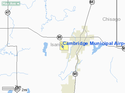
Cambridge Municipal Airport (ICAO: KCBG, FAA LID: CBG) is a city-owned, public-use airport located two miles (3 km) southwest of the central business district of Cambridge, a city in Isanti County, Minnesota, United States.
Although most U.S. airports use the same three-letter location identifier for the FAA and IATA, this airport is assigned CBG by the FAA but has no designation from the IATA (which assigned CBG to Cambridge Airport in Cambridge, England, United Kingdom).
Facilities and aircraft
Cambridge Municipal Airport covers an area of 280 acres (113 ha) and has one runway designated 16/34 with a 4,000 x 75 ft (1,219 x 23 m) asphalt surface. For the 12-month period ending May 30, 2006, the airport had 16,850 aircraft operations, an average of 46 per day: 99% general aviation and 1% military. At that time there were 47 aircraft based at this airport: 94% single-engine, 2% multi-engine and 4% helicopter.
The above content comes from Wikipedia and is published under free licenses – click here to read more.
Location & QuickFacts
| FAA Information Effective: | 2008-09-25 |
| Airport Identifier: | CBG |
| Airport Status: | Operational |
| Longitude/Latitude: | 093-15-51.0610W/45-33-26.9795N
-93.264184/45.557494 (Estimated) |
| Elevation: | 945 ft / 288.04 m (Surveyed) |
| Land: | 280 acres |
| From nearest city: | 2 nautical miles SW of Cambridge, MN |
| Location: | Isanti County, MN |
| Magnetic Variation: | 03E (1985) |
Owner & Manager
| Ownership: | Publicly owned |
| Owner: | City Of Cambridge |
| Address: | 300 Third Ave Ne
Cambridge, MN 55008 |
| Phone number: | 612-689-3211 |
| Manager: | Steve Wegwerth |
| Address: | 300 Third Ave Ne, 300 Third Avenue Ne
Cambridge, MN 55008 |
| Phone number: | 763-689-1800 |
Airport Operations and Facilities
| Airport Use: | Open to public |
| Wind indicator: | Yes |
| Segmented Circle: | No |
| Control Tower: | No |
| Lighting Schedule: | DUSK-DAWN
ACTVT MIRL RY 16/34, PAPI RY 16 & RY 34 & REIL RY 34 - CTAF. |
| Beacon Color: | Clear-Green (lighted land airport) |
| Landing fee charge: | No |
| Sectional chart: | Twin Cities |
| Region: | AGL - Great Lakes |
| Boundary ARTCC: | ZMP - Minneapolis |
| Tie-in FSS: | PNM - Princeton |
| FSS on Airport: | No |
| FSS Toll Free: | 1-800-WX-BRIEF |
| NOTAMs Facility: | CBG (NOTAM-d service avaliable) |
| Federal Agreements: | NGY |
Airport Communications
| CTAF: | 122.800 |
| Unicom: | 122.800 |
Airport Services
| Fuel available: | 100LL
SELF SERVICE FUEL AVBL WITH CREDIT CARD. |
| Airframe Repair: | MAJOR |
| Power Plant Repair: | MAJOR |
| Bottled Oxygen: | NONE |
| Bulk Oxygen: | NONE |
Runway Information
Runway 16/34
| Dimension: | 4000 x 75 ft / 1219.2 x 22.9 m |
| Surface: | ASPH, Good Condition |
| Weight Limit: | Single wheel: 19000 lbs. |
| Edge Lights: | Medium |
| |
Runway 16 |
Runway 34 |
| Longitude: | 093-15-59.5050W | 093-15-42.6170W |
| Latitude: | 45-33-45.8130N | 45-33-08.1460N |
| Elevation: | 942.00 ft | 938.00 ft |
| Alignment: | 127 | 127 |
| Traffic Pattern: | Left | Left |
| Markings: | Non-precision instrument, Good Condition | Non-precision instrument, Good Condition |
| Crossing Height: | 40.00 ft | 40.00 ft |
| VASI: | 4-light PAPI on right side | 4-light PAPI on left side |
| Visual Glide Angle: | 3.00° | 3.00° |
| Runway End Identifier: | No | Yes |
| Centerline Lights: | No | No |
| Touchdown Lights: | No | No |
| Obstruction: | 66 ft trees, 1800.0 ft from runway, 24:1 slope to clear | 65 ft trees, 1370.0 ft from runway, 230 ft right of centerline, 18:1 slope to clear |
|
Radio Navigation Aids
| ID |
Type |
Name |
Ch |
Freq |
Var |
Dist |
| PNM | NDB | Princeton | | 368.00 | 03E | 14.5 nm |
| ROS | NDB | Rush City | | 282.00 | 02E | 15.4 nm |
| JMR | NDB | Mora | | 327.00 | 03E | 20.0 nm |
| OEO | NDB | Osceola | | 233.00 | 01E | 28.5 nm |
| RNH | NDB | New Richmond | | 257.00 | 02E | 39.5 nm |
| BXR | NDB | Big Doctor | | 203.00 | 02E | 40.9 nm |
| AHH | NDB | Ameron | | 278.00 | 01E | 41.2 nm |
| PPI | NDB | Hopey | | 400.00 | 03E | 43.3 nm |
| MS | NDB | Narco | | 266.00 | 02E | 44.6 nm |
| STC | VOR/DME | St Cloud | 058X | 112.10 | 03E | 33.4 nm |
| MSP | VOR/DME | Minneapolis | 100X | 115.30 | 02E | 39.7 nm |
| RZN | VOR/DME | Siren | 031X | 109.40 | 02E | 40.6 nm |
| FCM | VOR/DME | Flying Cloud | 055X | 111.80 | 06E | 44.7 nm |
| GEP | VORTAC | Gopher | 120X | 117.30 | 06E | 25.2 nm |
| STP | VOT | St Paul | | 114.40 | | 38.1 nm |
| MSP | VOT | Minneapolis St Paul | | 111.00 | | 40.5 nm |
Remarks
- MIGRATORY WATERFOWL & DEER ON & INVOF ARPT.
- FOR NOISE ABATEMENT, ACFT DEPARTING RY 16 FLY RY HEADING TO 1945 FT MSL (1000 FT AGL) & 2 NM BEFORE L TURN
Images and information placed above are from
http://www.airport-data.com/airport/CBG/
We thank them for the data!
| General Info
|
| Country |
United States
|
| State |
MINNESOTA
|
| FAA ID |
CBG
|
| Latitude |
45-33-34.517N
|
| Longitude |
093-15-54.441W
|
| Elevation |
945 feet
|
| Near City |
CAMBRIDGE
|
We don't guarantee the information is fresh and accurate. The data may
be wrong or outdated.
For more up-to-date information please refer to other sources.
|
|


