 |
|
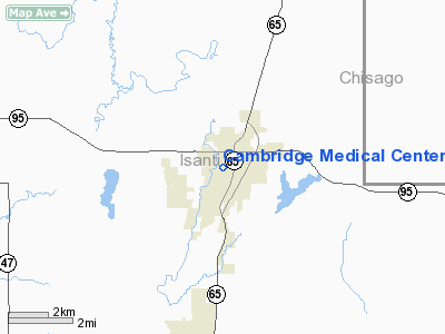
Cambridge Medical Center Heliport |
Location & QuickFacts
| FAA Information Effective: | 2008-09-25 |
| Airport Identifier: | 2MY3 |
| Airport Status: | Operational |
| Longitude/Latitude: | 093-13-52.9000W/45-33-55.6200N
-93.231361/45.565450 (Estimated) |
| Elevation: | 980 ft / 298.70 m (Estimated) |
| Land: | 0 acres |
| From nearest city: | 0 nautical miles N of Cambridge, MN |
| Location: | Isanti County, MN |
| Magnetic Variation: | () |
Owner & Manager
| Ownership: | Privately owned |
| Owner: | Cambridge Medical Center |
| Address: | 701 S. Dellwood
Cambridge, MN 55008 |
| Phone number: | 763-689-7762 |
| Manager: | Dee Gross |
| Address: | Cambridge Medical Center, 701 S. Dellwood
Cambridge, MN 55008 |
| Phone number: | 763-689-7762 |
Airport Operations and Facilities
| Airport Use: | Private |
| Control Tower: | No |
| Lighting Schedule: | DUSK-DAWN |
| Sectional chart: | Twin Cities |
| Region: | AGL - Great Lakes |
| Boundary ARTCC: | ZMP - Minneapolis |
| Tie-in FSS: | PNM - Princeton |
| FSS Toll Free: | 1-800-WX-BRIEF |
Runway Information
Helipad H1
| Dimension: | 80 x 80 ft / 24.4 x 24.4 m |
| Surface: | CONC, |
| |
Runway H1 |
Runway |
| Traffic Pattern: | Left | Left |
|
Radio Navigation Aids
| ID |
Type |
Name |
Ch |
Freq |
Var |
Dist |
| CBG | NDB | Cambridge | | 350.00 | 03E | 1.4 nm |
| ROS | NDB | Rush City | | 282.00 | 02E | 14.0 nm |
| PNM | NDB | Princeton | | 368.00 | 03E | 15.8 nm |
| JMR | NDB | Mora | | 327.00 | 03E | 19.6 nm |
| OEO | NDB | Osceola | | 233.00 | 01E | 27.6 nm |
| RNH | NDB | New Richmond | | 257.00 | 02E | 38.7 nm |
| BXR | NDB | Big Doctor | | 203.00 | 02E | 39.4 nm |
| AHH | NDB | Ameron | | 278.00 | 01E | 40.1 nm |
| PPI | NDB | Hopey | | 400.00 | 03E | 43.4 nm |
| MS | NDB | Narco | | 266.00 | 02E | 44.9 nm |
| STC | VOR/DME | St Cloud | 058X | 112.10 | 03E | 34.8 nm |
| RZN | VOR/DME | Siren | 031X | 109.40 | 02E | 39.1 nm |
| MSP | VOR/DME | Minneapolis | 100X | 115.30 | 02E | 40.2 nm |
| FCM | VOR/DME | Flying Cloud | 055X | 111.80 | 06E | 45.5 nm |
| GEP | VORTAC | Gopher | 120X | 117.30 | 06E | 25.9 nm |
| STP | VOT | St Paul | | 114.40 | | 38.2 nm |
| MSP | VOT | Minneapolis St Paul | | 111.00 | | 41.0 nm |
Remarks
- PRVDD APCH/DEP FM 150 TO 210 DEGRESS & 260 TO 300 DEGRESS; THE SIGN IN THE NW CORNER BE MOVED; AREA IS MARKED; RESTRAIN UNATHORIZED PERSONNELFK ACCESS TO PAD; THE PERI LGHTS ARE 15 INCHES ABOVE TLOF; PROPONENT NOTIFIES HELO OPERATORS OF LOCATION OF THE MAGNETIC RESONANCE IMAGERS.
Images and information placed above are from
http://www.airport-data.com/airport/2MY3/
We thank them for the data!
We don't guarantee the information is fresh and accurate. The data may
be wrong or outdated.
For more up-to-date information please refer to other sources.
|
|


