 |
|
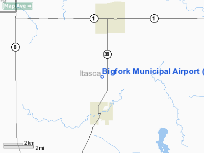
Bigfork Municipal Airport |
Location & QuickFacts
| FAA Information Effective: | 2008-09-25 |
| Airport Identifier: | FOZ |
| Airport Status: | Operational |
| Longitude/Latitude: | 093-39-00.7000W/47-46-58.2000N
-93.650194/47.782833 (Estimated) |
| Elevation: | 1348 ft / 410.87 m (Surveyed) |
| Land: | 160 acres |
| From nearest city: | 2 nautical miles N of Bigfork, MN |
| Location: | Itasca County, MN |
| Magnetic Variation: | 02E (1995) |
Owner & Manager
| Ownership: | Publicly owned |
| Owner: | City Of Bigfork |
| Address: | Box 197
Bigfork, MN 56628 |
| Phone number: | 218-743-3782 |
| Manager: | Loren E. Hovila |
| Address: | Box 336
Bigfork, MN 56628 |
| Phone number: | 218-743-3640 |
Airport Operations and Facilities
| Airport Use: | Open to public |
| Wind indicator: | Yes |
| Segmented Circle: | No |
| Control Tower: | No |
| Lighting Schedule: | DUSK-DAWN
ACTVT MIRL RY 15/33 - CTAF. |
| Beacon Color: | Clear-Green (lighted land airport) |
| Landing fee charge: | No |
| Sectional chart: | Twin Cities |
| Region: | AGL - Great Lakes |
| Boundary ARTCC: | ZMP - Minneapolis |
| Tie-in FSS: | PNM - Princeton |
| FSS on Airport: | No |
| FSS Toll Free: | 1-800-WX-BRIEF |
| NOTAMs Facility: | FOZ (NOTAM-d service avaliable) |
Airport Communications
Airport Services
| Airframe Repair: | NONE |
| Power Plant Repair: | NONE |
| Bottled Oxygen: | NONE |
| Bulk Oxygen: | NONE |
Runway Information
Runway 15/33
| Dimension: | 3100 x 75 ft / 944.9 x 22.9 m |
| Surface: | ASPH, Fair Condition
CRACKS. |
| Edge Lights: | Medium |
| |
Runway 15 |
Runway 33 |
| Longitude: | 093-39-11.7000W | 093-38-49.7000W |
| Latitude: | 47-47-11.6000N | 47-46-44.8000N |
| Elevation: | 1348.00 ft | 1345.00 ft |
| Alignment: | 127 | 127 |
| Traffic Pattern: | Left | Left |
| Markings: | Non-precision instrument, Good Condition | Non-precision instrument, Good Condition |
| Obstruction: | , 50:1 slope to clear
BRUSH +4, 0-200 FM RWY END, 225L. | 15 ft trees, 545.0 ft from runway, 225 ft left of centerline, 28:1 slope to clear |
|
Radio Navigation Aids
| ID |
Type |
Name |
Ch |
Freq |
Var |
Dist |
| FOZ | NDB | Bigfork | | 345.00 | 02E | 0.2 nm |
| ORB | NDB | Orr | | 341.00 | 02E | 34.8 nm |
| CQM | NDB | Cook | | 233.00 | 01E | 38.8 nm |
| IN | NDB | Raize | | 353.00 | 06E | 44.6 nm |
| GPZ | VOR/DME | Grand Rapids | 051X | 111.40 | 06E | 37.8 nm |
| HIB | VOR/DME | Hibbing | 045X | 110.80 | 02E | 48.1 nm |
| INL | VORTAC | International Falls | 047X | 111.00 | 06E | 48.1 nm |
Remarks
- 350' MICRO TWR 2 MILES SOUTH OF RWY.
- DEER & WATERFOWL ON AND INVOF ARPT.
- ULTRALIGHTS ON & INVOF ARPT.
- GCO AVBL ON FREQ 121.725 THRU MINNEAPOLIS ARTCC & FLT SVCS.
- ESTAB PRIOR TO 1959.
Images and information placed above are from
http://www.airport-data.com/airport/FOZ/
We thank them for the data!
| General Info
|
| Country |
United States
|
| State |
MINNESOTA
|
| FAA ID |
FOZ
|
| Latitude |
47-46-58.200N
|
| Longitude |
093-39-00.700W
|
| Elevation |
1348 feet
|
| Near City |
BIGFORK
|
We don't guarantee the information is fresh and accurate. The data may
be wrong or outdated.
For more up-to-date information please refer to other sources.
|
|


