 |
|
| Benson Municipal Airport |
| IATA: BBB – ICAO: KBBB – FAA LID: BBB |
| Summary |
| Airport type |
Public |
| Owner |
City of Benson |
| Serves |
Benson, Minnesota |
| Elevation AMSL |
1,039 ft / 317 m |
| Coordinates |
45°19′55″N 095°39′02″W / 45.33194°N 95.65056°W / 45.33194; -95.65056 |
| Runways |
| Direction |
Length |
Surface |
| ft |
m |
| 14/32 |
4,000 |
1,219 |
Asphalt |
| Statistics (2006) |
| Aircraft operations |
5,100 |
| Based aircraft |
12 |
| Source: Federal Aviation Administration |
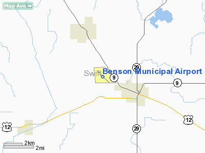
Benson Municipal Airport (IATA: BBB, ICAO: KBBB, FAA LID: BBB) is a city-owned, public-use airport located two miles (3 km) west of the central business district of Benson, a city in Swift County, Minnesota, United States.
Facilities and aircraft
Benson Municipal Airport covers an area of 331 acres (134 ha) and has one runway designated 14/32 with an asphalt surface measuring 4,000 by 75 feet (1,219 x 23 m). For the 12-month period ending July 31, 2006, the airport had 5,100 aircraft operations, an average of 13 per day: 98% general aviation and 2% air taxi. There are 12 aircraft based at this airport: 92% single-engine and 8% ultralight.
The above content comes from Wikipedia and is published under free licenses – click here to read more.
Location & QuickFacts
| FAA Information Effective: | 2008-09-25 |
| Airport Identifier: | BBB |
| Airport Status: | Operational |
| Longitude/Latitude: | 095-39-02.1000W/45-19-54.9000N
-95.650583/45.331917 (Estimated) |
| Elevation: | 1039 ft / 316.69 m (Surveyed) |
| Land: | 331 acres |
| From nearest city: | 2 nautical miles W of Benson, MN |
| Location: | Swift County, MN |
| Magnetic Variation: | 05E (1985) |
Owner & Manager
| Ownership: | Publicly owned |
| Owner: | City Of Benson |
| Address: | 1410 Kansas Ave
Benson, MN 56215 |
| Phone number: | 320-843-4775 |
| Manager: | Elliott Nelson |
| Address: | 1320 Nevada Ave
Benson, MN 56215 |
| Phone number: | 320-843-4775 |
Airport Operations and Facilities
| Airport Use: | Open to public |
| Wind indicator: | Yes |
| Segmented Circle: | No |
| Control Tower: | No |
| Lighting Schedule: | DUSK-DAWN
ACTVT MIRL RY 14/32 & PAPI RY 32 & REIL RYS 14 & 32 - CTAF. |
| Beacon Color: | Clear-Green (lighted land airport) |
| Landing fee charge: | No |
| Sectional chart: | Twin Cities |
| Region: | AGL - Great Lakes |
| Boundary ARTCC: | ZMP - Minneapolis |
| Tie-in FSS: | PNM - Princeton |
| FSS on Airport: | No |
| FSS Toll Free: | 1-800-WX-BRIEF |
| NOTAMs Facility: | BBB (NOTAM-d service avaliable) |
| Federal Agreements: | NGY |
Airport Communications
| CTAF: | 122.800 |
| Unicom: | 122.800 |
Airport Services
| Fuel available: | 100LL
SELF SERVE FUEL AVAIL 24 HRS WITH CREDIT CARD. |
| Airframe Repair: | MINOR |
| Power Plant Repair: | MINOR |
| Bottled Oxygen: | NONE |
| Bulk Oxygen: | NONE |
Runway Information
Runway 14/32
| Dimension: | 4000 x 75 ft / 1219.2 x 22.9 m |
| Surface: | ASPH, Good Condition |
| Weight Limit: | Single wheel: 40000 lbs.
Dual wheel: 50000 lbs. |
| Edge Lights: | Medium |
| |
Runway 14 |
Runway 32 |
| Longitude: | 095-39-18.7094W | 095-38-45.4027W |
| Latitude: | 45-20-10.8285N | 45-19-39.0780N |
| Elevation: | 1038.00 ft | 1039.00 ft |
| Alignment: | 127 | 127 |
| Traffic Pattern: | Right | Left |
| Markings: | Non-precision instrument, Good Condition | Non-precision instrument, Good Condition |
| Crossing Height: | 40.00 ft | 41.00 ft |
| VASI: | 4-light PAPI on left side
RY 14 PAPI UNSUBL BYD 2 NM. | 4-light PAPI on left side
RY 32 PAPI UNUSBL BYD 2 NM & BYD 5 DEGS LEFT & RIGHT OF RY CNTRLN. |
| Visual Glide Angle: | 3.00° | 3.00° |
| Runway End Identifier: | Yes | Yes |
| Centerline Lights: | No | No |
| Touchdown Lights: | No | No |
| Obstruction: | 10 ft trees, 325.0 ft from runway, 200 ft right of centerline, 12:1 slope to clear
TREES +37, 965 FT FM END 360 R, 20:1. | 75 ft trees, 1280.0 ft from runway, 200 ft left of centerline, 14:1 slope to clear
TREES +81 FT, 1400 FM END 270 R, 14:1. |
|
Radio Navigation Aids
| ID |
Type |
Name |
Ch |
Freq |
Var |
Dist |
| BBB | NDB | Benson | | 239.00 | 05E | 0.3 nm |
| AQP | NDB | Appleton | | 356.00 | 05E | 16.4 nm |
| GHW | NDB | Glenwood | | 346.00 | 03E | 23.4 nm |
| DXX | NDB | Dawson/madison | | 341.00 | 06E | 30.6 nm |
| EE | NDB | Tamie | | 374.00 | 04E | 31.2 nm |
| VVV | NDB | Ortonville | | 332.00 | 05E | 32.6 nm |
| ETH | NDB | Wheaton | | 326.00 | 05E | 46.5 nm |
| MOX | VOR/DME | Morris | 033X | 109.60 | 05E | 19.4 nm |
| MVE | VOR/DME | Montevideo | 053X | 111.60 | 05E | 21.7 nm |
| BDH | VOR/DME | Willmar | 84X | 113.70 | 04E | 25.6 nm |
| ILL | VOR/DME | Willmar | 084X | 113.70 | 04E | 27.0 nm |
| AXN | VOR/DME | Alexandria | 075X | 112.80 | 07E | 41.5 nm |
Remarks
- ULTRALIGHT ACFT ON AND INVOF OF THE AIRPORT.
- CATEGORY 'C' & 'D' ACFT OPNS PROHIBITED.
Images and information placed above are from
http://www.airport-data.com/airport/BBB/
We thank them for the data!
| General Info
|
| Country |
United States
|
| State |
MINNESOTA
|
| FAA ID |
BBB
|
| Latitude |
45-19-54.957N
|
| Longitude |
095-39-02.034W
|
| Elevation |
1039 feet
|
| Near City |
BENSON
|
We don't guarantee the information is fresh and accurate. The data may
be wrong or outdated.
For more up-to-date information please refer to other sources.
|
|


