 |
|
Baudette International Airport |
| Baudette International Airport |
| IATA: BDE – ICAO: KBDE – FAA LID: BDE |
| Summary |
| Airport type |
Public |
| Owner |
Lake of the Woods County |
| Serves |
Baudette, Minnesota |
| Elevation AMSL |
1,086 ft / 331 m |
| Coordinates |
48°43′42″N 094°36′44″W / 48.72833°N 94.61222°W / 48.72833; -94.61222 |
| Runways |
| Direction |
Length |
Surface |
| ft |
m |
| 12/30 |
5,499 |
1,676 |
Asphalt |
| 13W/31W |
6,000 |
1,829 |
Water |
| Statistics (2007) |
| Aircraft operations |
12,825 |
| Based aircraft |
17 |
| Source: Federal Aviation Administration |
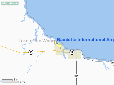
Baudette International Airport (IATA: BDE, ICAO: KBDE, FAA LID: BDE) is a county-owned, public-use airport located one mile (2 km) north of the central business district of Baudette, a city in Lake of the Woods County, Minnesota, United States. Also known as Baudette International Airport & Seaplane Base, it is located on the Rainy River, which is the border between Minnesota in the U.S. and Ontario in Canada.
Facilities and aircraft
Baudette International Airport covers an area of 364 acres (147 ha) at an altitude of 1,086 feet (331 m) above mean sea level. It has one runway designated 12/30 with a 5,499 x 100 ft (1,676 x 30 m) asphalt surface. The airport also has a seaplane landing area designated 13W/31W and measuring 6,000 x 1,200 ft (1,829 x 366 m) which is located on Rainy River.
For the 12-month period ending July 31, 2007, the airport had 12,825 aircraft operations, an average of 35 per day: 94% general aviation, 5% air taxi and 1% military. At that time there were 17 aircraft based at this airport: 88% single-engine, 6% multi-engine and 6% ultralight.
The above content comes from Wikipedia and is published under free licenses – click here to read more.
Location & QuickFacts
| FAA Information Effective: | 2008-09-25 |
| Airport Identifier: | BDE |
| Airport Status: | Operational |
| Longitude/Latitude: | 094-36-44.0000W/48-43-42.4000N
-94.612222/48.728444 (Estimated) |
| Elevation: | 1086 ft / 331.01 m (Surveyed) |
| Land: | 364 acres |
| From nearest city: | 1 nautical miles N of Baudette, MN |
| Location: | Lake Of The Woods County, MN |
| Magnetic Variation: | 04E (1990) |
Owner & Manager
| Ownership: | Publicly owned |
| Owner: | Lake Of The Woods County
AND CITY OF BAUDETTE. |
| Address: | 206 Se 8 Ave
Baudette, MN 56623 |
| Phone number: | 218-634-1767 |
| Manager: | Emory Vaagen |
| Address: | P.o. Box 712
Baudette, MN 56623 |
| Phone number: | 218-634-1923 |
Airport Operations and Facilities
| Airport Use: | Open to public |
| Wind indicator: | Yes |
| Segmented Circle: | Yes |
| Control Tower: | No |
| Lighting Schedule: | DUSK-DAWN
ACTVT MIRL RY 12/30, REIL & VASI RYS 12 & 30 - CTAF. |
| Beacon Color: | Clear-Green (lighted land airport) |
| Landing fee charge: | No |
| Sectional chart: | Twin Cities |
| Region: | AGL - Great Lakes |
| Boundary ARTCC: | ZMP - Minneapolis |
| Tie-in FSS: | PNM - Princeton |
| FSS on Airport: | No |
| FSS Toll Free: | 1-800-WX-BRIEF |
| NOTAMs Facility: | BDE (NOTAM-d service avaliable) |
| Federal Agreements: | NGY |
Airport Communications
| CTAF: | 122.800 |
| Unicom: | 122.800 |
Airport Services
| Fuel available: | 100LLA |
| Airframe Repair: | MAJOR |
| Power Plant Repair: | MAJOR |
| Bottled Oxygen: | NONE |
| Bulk Oxygen: | NONE |
Runway Information
Runway 12/30
| Dimension: | 5499 x 100 ft / 1676.1 x 30.5 m |
| Surface: | ASPH, Good Condition |
| Weight Limit: | Single wheel: 30000 lbs. |
| Edge Lights: | Medium |
| |
Runway 12 |
Runway 30 |
| Longitude: | 094-37-19.1601W | 094-36-08.7346W |
| Latitude: | 48-43-56.2956N | 48-43-28.4995N |
| Elevation: | 1085.00 ft | 1083.00 ft |
| Alignment: | 121 | 127 |
| Traffic Pattern: | Left | Left |
| Markings: | Non-precision instrument, Good Condition | Non-precision instrument, Good Condition |
| Crossing Height: | 45.00 ft | 51.00 ft |
| VASI: | 2-box on left side | 2-box on left side |
| Visual Glide Angle: | 3.00° | 3.00° |
| Runway End Identifier: | Yes | Yes |
| Centerline Lights: | No | No |
| Touchdown Lights: | No | No |
| Obstruction: | 50 ft tree, 2188.0 ft from runway, 218 ft left of centerline, 39:1 slope to clear | 44 ft trees, 930.0 ft from runway, 170 ft right of centerline, 16:1 slope to clear |
|
Runway 13W/31W
| Dimension: | 6000 x 1200 ft / 1828.8 x 365.8 m |
| Surface: | WATER, |
| |
Runway 13W |
Runway 31W |
| Traffic Pattern: | Left | Left |
|
Radio Navigation Aids
| ID |
Type |
Name |
Ch |
Freq |
Var |
Dist |
| YAG | NDB | Fort Frances | | 376.00 | 02E | 42.6 nm |
| BDE | VOR/DME | Baudette | 053X | 111.60 | 04E | 0.4 nm |
| ROX | VOR/DME | Roseau | 025X | 108.80 | 05E | 43.5 nm |
| INL | VORTAC | International Falls | 047X | 111.00 | 06E | 48.9 nm |
Remarks
- TWY PARALLEL TO RY 12/30 IS CLSD WINTER MONTHS.
- SEAPLANE LNDG AREA ADJACENT NORTH OF LAND FACILITY.
- CTN: GULLS & OTHER BIRDS ON & INVOF ARPT.
- ULTRALIGHTS ON & INVOF ARPT.
Images and information placed above are from
http://www.airport-data.com/airport/BDE/
We thank them for the data!
| General Info
|
| Country |
United States
|
| State |
MINNESOTA
|
| FAA ID |
BDE
|
| Latitude |
48-43-42.400N
|
| Longitude |
094-36-44.000W
|
| Elevation |
1086 feet
|
| Near City |
BAUDETTE
|
We don't guarantee the information is fresh and accurate. The data may
be wrong or outdated.
For more up-to-date information please refer to other sources.
|
|


