 |
|
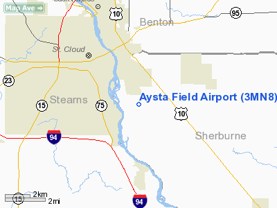
Location & QuickFacts
| FAA Information Effective: | 2008-09-25 |
| Airport Identifier: | 3MN8 |
| Airport Status: | Operational |
| Longitude/Latitude: | 094-07-21.9550W/45-31-21.8750N
-94.122765/45.522743 (Estimated) |
| Elevation: | 1024 ft / 312.12 m (Estimated) |
| Land: | 11 acres |
| From nearest city: | 2 nautical miles SE of St Cloud, MN |
| Location: | Sherburne County, MN |
| Magnetic Variation: | 04E (1985) |
Owner & Manager
| Ownership: | Privately owned |
| Owner: | Gary Aysta |
| Address: | 3259 Co. Rd 8
St Cloud, MN 56304 |
| Phone number: | 612-259-1871 |
| Manager: | Gary Aysta |
| Address: | 3259 Co. Rd 8
St Cloud, MN 56304 |
| Phone number: | 612-259-1871 |
Airport Operations and Facilities
| Airport Use: | Private
PERSONAL USE. |
| Wind indicator: | Yes |
| Segmented Circle: | No |
| Control Tower: | No |
| Sectional chart: | Omaha |
| Region: | AGL - Great Lakes |
| Boundary ARTCC: | ZMP - Minneapolis |
| Tie-in FSS: | PNM - Princeton |
| FSS Toll Free: | 1-800-WX-BRIEF |
Runway Information
Runway 09/27
| Dimension: | 1200 x 100 ft / 365.8 x 30.5 m |
| Surface: | TURF, |
| |
Runway 09 |
Runway 27 |
| Traffic Pattern: | Left | Left |
| Displaced threshold: | 600.00 ft | 0.00 ft |
| Obstruction: | 30 ft pline, 600.0 ft from runway | |
|
Radio Navigation Aids
| ID |
Type |
Name |
Ch |
Freq |
Var |
Dist |
| PNM | NDB | Princeton | | 368.00 | 03E | 21.8 nm |
| LXL | NDB | Little Falls | | 359.00 | 03E | 27.3 nm |
| XCR | NDB | Ripley | | 404.00 | 03E | 34.7 nm |
| CBG | NDB | Cambridge | | 350.00 | 03E | 36.3 nm |
| HCD | NDB | Hutchinson | | 209.00 | 04E | 41.5 nm |
| JMR | NDB | Mora | | 327.00 | 03E | 42.1 nm |
| GYL | NDB | Glencoe | | 407.00 | 03E | 45.8 nm |
| RYM | TACAN | Camp Ripley | 048X | | 03E | 35.5 nm |
| STC | VOR/DME | St Cloud | 058X | 112.10 | 03E | 3.1 nm |
| ILL | VOR/DME | Willmar | 084X | 113.70 | 04E | 47.6 nm |
| BDH | VOR/DME | Willmar | 84X | 113.70 | 04E | 48.9 nm |
| DWN | VORTAC | Darwin | 027X | 109.00 | 07E | 29.7 nm |
| GEP | VORTAC | Gopher | 120X | 117.30 | 06E | 38.9 nm |
| BRD | VORTAC | Brainerd | 116X | 116.90 | 03E | 49.8 nm |
Remarks
- PROVIDED THAT RY THR GIVES A 20:1 APCH CLEARANCE; AREA 125 FT EITHER SIDE OF RY AND 300 FT OF EITHER END IS CLEAR FROM OBSTRUCTIONS.
Images and information placed above are from
http://www.airport-data.com/airport/3MN8/
We thank them for the data!
| General Info
|
| Country |
United States
|
| State |
MINNESOTA
|
| FAA ID |
3MN8
|
| Latitude |
45-31-21.875N
|
| Longitude |
094-07-21.955W
|
| Elevation |
1024 feet
|
| Near City |
ST CLOUD
|
We don't guarantee the information is fresh and accurate. The data may
be wrong or outdated.
For more up-to-date information please refer to other sources.
|
|


