|
|
Albert Lea Municipal Airport |
| Albert Lea Municipal Airport |
| IATA: AEL – ICAO: KAEL – FAA LID: AEL |
| Summary |
| Airport type |
Public |
| Owner |
City of Albert Lea |
| Serves |
Albert Lea, Minnesota |
| Elevation AMSL |
1,260 ft / 384 m |
| Coordinates |
43°40′54″N 093°22′02″W / 43.68167°N 93.36722°W / 43.68167; -93.36722 |
| Website |
www.cityofalbertlea.org |
| Runways |
| Direction |
Length |
Surface |
| ft |
m |
| 16/34 |
4,501 |
1,372 |
Asphalt |
| 4/22 |
2,898 |
883 |
Asphalt |
| Statistics (2008) |
| Aircraft operations |
26,175 |
| Based aircraft |
40 |
| Source: Federal Aviation Administration |
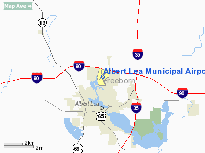
Albert Lea Municipal Airport (ICAO: KAEL, FAA LID: AEL) is a city-owned, public-use airport located three nautical miles (6 km) north of the central business district of the city of Albert Lea, in Freeborn County, Minnesota, United States.
Albert Lea Municipal Airport was recently granted over $3 million dollars in federal economic stimulus funds to relocate the main runway. The announcement follows another recent grant to rehabilitate the airport's crosswind runway. Facilities and aircraft
Albert Lea Municipal Airport covers an area of 273 acres (110 ha) at an elevation of 1,260 feet (384 m) above mean sea level. It has two asphalt paved runways: 16/34 is 4,501 by 100 feet (1,372 x 30 m) and 4/22 is 2,898 by 75 feet (883 x 23 m).
For the 12-month period ending April 30, 2008, the airport had 26,175 aircraft operations, an average of 71 per day: 91% general aviation, 8% air taxi and 1% military. At that time there were 40 aircraft based at this airport: 75% single-engine, 5% multi-engine, 5% glider and 15% ultralight.
Soaring contests
In the last 15 years, there have been 8 major soaring contests at the Albert Lea Airport. The airport holds the distinction of being the only site in the United States to have hosted all seven classes of glider competition.
- 1992 U.S. Region 7 Contest
- 1993 1-26 Championships
- 1995 U.S. Sports Class Nationals
- 1997 U.S. 15m Nationals
- 1999 U.S. World Class Nationals and Region 7 Contest
- 2002 U.S. Region 7 Contest
- 2005 U.S. Region 7 Contest
- 2007 U.S. Open Class Nationals
- 2007 U.S. 18 m Class Nationals
- 2007 U.S. Region 7 Sport Class Contest
From 1990-2008 Albert Lea was the host site for the International Aerobatic Club Doug Yost Challenge Aerobatic Competition. This contest was moved to Spencer, Iowa due to construction in the area needed for the contest.
The above content comes from Wikipedia and is published under free licenses – click here to read more.
|
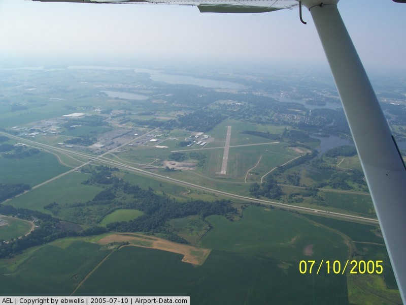
 |
(Click on the photo to enlarge) |
|
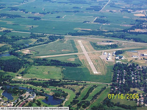
 |
(Click on the photo to enlarge) |
Location & QuickFacts
| FAA Information Effective: | 2008-09-25 |
| Airport Identifier: | AEL |
| Airport Status: | Operational |
| Longitude/Latitude: | 093-22-02.1000W/43-40-53.5000N
-93.367250/43.681528 (Estimated) |
| Elevation: | 1260 ft / 384.05 m (Surveyed) |
| Land: | 273 acres |
| From nearest city: | 3 nautical miles N of Albert Lea, MN |
| Location: | Freeborn County, MN |
| Magnetic Variation: | 05E (1980) |
Owner & Manager
| Ownership: | Publicly owned |
| Owner: | City Of Albert Lea |
| Address: | 221 E Clark Street
Albert Lea, MN 56007 |
| Phone number: | 507-377-4300 |
| Manager: | Jim Hanson |
| Address: | 73950 275th St.
Clarks Grove, MN 56016 |
| Phone number: | 507-373-0608 |
Airport Operations and Facilities
| Airport Use: | Open to public |
| Wind indicator: | Yes |
| Segmented Circle: | Yes |
| Control Tower: | No |
| Lighting Schedule: | DUSK-DAWN
DAYS: ACTVT MIRL RY 16/34; VASI & REIL RYS 16 & 34 - CTAF. NGTS: VASI CONTINUOUS; MIRL RY 16/34 INTST PRESET TO INCR INTST & ACTVT REIL 16 & 34 - CTAF. |
| Beacon Color: | Clear-Green (lighted land airport) |
| Landing fee charge: | No |
| Sectional chart: | Omaha |
| Region: | AGL - Great Lakes |
| Traffic Pattern Alt: | 740 ft |
| Boundary ARTCC: | ZMP - Minneapolis |
| Tie-in FSS: | PNM - Princeton |
| FSS on Airport: | No |
| FSS Toll Free: | 1-800-WX-BRIEF |
| NOTAMs Facility: | AEL (NOTAM-d service avaliable) |
| Federal Agreements: | NGY |
Airport Communications
| CTAF: | 123.000 |
| Unicom: | 123.000 |
Airport Services
| Fuel available: | 100LLA MOGAS
MOGAS PUMP NOT MARKED. |
| Airframe Repair: | MAJOR |
| Power Plant Repair: | MAJOR |
| Bottled Oxygen: | NONE |
| Bulk Oxygen: | NONE |
Runway Information
Runway 04/22
| Dimension: | 2898 x 75 ft / 883.3 x 22.9 m |
| Surface: | ASPH, Good Condition |
| |
Runway 04 |
Runway 22 |
| Longitude: | 093-22-17.0242W | 093-21-48.3993W |
| Latitude: | 43-40-44.6930N | 43-41-04.3751N |
| Elevation: | 1253.00 ft | 1257.00 ft |
| Alignment: | 47 | 127 |
| Traffic Pattern: | Left | Left |
| Markings: | Non-precision instrument, Good Condition | Non-precision instrument, Good Condition |
| Runway End Identifier: | No | No |
| Centerline Lights: | No | No |
| Touchdown Lights: | No | No |
| Obstruction: | 8 ft trees, 390.0 ft from runway, 30 ft right of centerline, 23:1 slope to clear | 31 ft pole, 1467.0 ft from runway, 125 ft left of centerline, 40:1 slope to clear |
|
Runway 16/34
| Dimension: | 4501 x 100 ft / 1371.9 x 30.5 m |
| Surface: | ASPH, Good Condition |
| Weight Limit: | Single wheel: 19000 lbs.
Dual wheel: 29000 lbs. |
| Edge Lights: | Non-standard lighting system
NSTD MIRL, 360 DEG WHITE GLOBES FULL LENGTH NO AMBER LGTS. |
| |
Runway 16 |
Runway 34 |
| Longitude: | 093-22-07.8977W | 093-21-55.3603W |
| Latitude: | 43-41-14.6036N | 43-40-31.0970N |
| Elevation: | 1260.00 ft | 1255.00 ft |
| Alignment: | 127 | 127 |
| Traffic Pattern: | Left | Left |
| Markings: | Non-precision instrument, Good Condition | Non-precision instrument, Good Condition |
| VASI: | 2-box on left side | 2-box on left side |
| Runway End Identifier: | Yes | Yes |
| Centerline Lights: | No | No |
| Touchdown Lights: | No | No |
| Obstruction: | 16 ft trees, 850.0 ft from runway, 75 ft left of centerline, 40:1 slope to clear | 64 ft tree, 1200.0 ft from runway, 250 ft right of centerline, 15:1 slope to clear |
|
Radio Navigation Aids
| ID |
Type |
Name |
Ch |
Freq |
Var |
Dist |
| ACQ | NDB | Waseca | | 371.00 | 02E | 24.7 nm |
| FXY | NDB | Forest City | | 359.00 | 05E | 29.0 nm |
| SBU | NDB | Blue Earth | | 332.00 | 04E | 32.1 nm |
| IY | NDB | Chukk | | 417.00 | 03E | 43.2 nm |
| CCY | NDB | Charles City | | 375.00 | 03E | 49.6 nm |
| AEL | VOR/DME | Albert Lea | 035X | 109.80 | 05E | 0.2 nm |
| JAY | VOR/DME | Austin | 019X | 108.20 | 03E | 20.5 nm |
| FOW | VOR/DME | Halfway | 049X | 111.20 | 02E | 31.4 nm |
| RST | VOR/DME | Rochester | 057X | 112.00 | 05E | 34.0 nm |
| MKT | VOR/DME | Mankato | 045X | 110.80 | 07E | 40.0 nm |
| FRM | VOR/DME | Fairmont | 039X | 110.20 | 07E | 45.9 nm |
| MCW | VORTAC | Mason City | 096X | 114.90 | 06E | 35.3 nm |
Remarks
- TV TWR 9.5 NM SE.
- UL, GLD & HELO USE TURF PARALLEL TO RY 16/34 ON E SIDE & APPR AREA TO RY 22.
Images and information placed above are from
http://www.airport-data.com/airport/AEL/
We thank them for the data!
| General Info
|
| Country |
United States
|
| State |
MINNESOTA
|
| FAA ID |
AEL
|
| Latitude |
43-40-53.446N
|
| Longitude |
093-22-02.056W
|
| Elevation |
1259 feet
|
| Near City |
ALBERT LEA
|
We don't guarantee the information is fresh and accurate. The data may
be wrong or outdated.
For more up-to-date information please refer to other sources.
|
|