 |
|
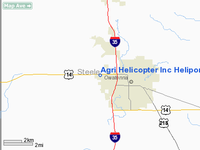
Agri Helicopter Inc Heliport |
Location & QuickFacts
| FAA Information Effective: | 2008-09-25 |
| Airport Identifier: | 3MN4 |
| Airport Status: | Operational |
| Longitude/Latitude: | 093-16-04.7640W/44-05-38.8660N
-93.267990/44.094129 (Estimated) |
| Elevation: | 1148 ft / 349.91 m (Estimated) |
| Land: | 0 acres |
| From nearest city: | 0 nautical miles W of Owatonna, MN |
| Location: | Steele County, MN |
| Magnetic Variation: | 03E (1985) |
Owner & Manager
| Ownership: | Privately owned |
| Owner: | Neil Tellijohn |
| Address: | 840 Havana Rd
Owatonna, MN 55060 |
| Phone number: | 507-451-0782 |
| Address: |
|
Airport Operations and Facilities
| Airport Use: | Private
PERSONAL USE. |
| Wind indicator: | Yes |
| Segmented Circle: | No |
| Control Tower: | No |
| Landing fee charge: | No |
| Sectional chart: | Omaha |
| Region: | AGL - Great Lakes |
| Boundary ARTCC: | ZMP - Minneapolis |
| Tie-in FSS: | PNM - Princeton |
| FSS on Airport: | No |
| FSS Toll Free: | 1-800-WX-BRIEF |
Runway Information
Helipad H1
| Dimension: | 60 x 60 ft / 18.3 x 18.3 m |
| Surface: | CONC, |
| |
Runway H1 |
Runway |
| Traffic Pattern: | Left | Left |
|
Radio Navigation Aids
| ID |
Type |
Name |
Ch |
Freq |
Var |
Dist |
| ACQ | NDB | Waseca | | 371.00 | 02E | 12.4 nm |
| MS | NDB | Narco | | 266.00 | 02E | 44.6 nm |
| SBU | NDB | Blue Earth | | 332.00 | 04E | 46.7 nm |
| PPI | NDB | Hopey | | 400.00 | 03E | 48.9 nm |
| FOW | VOR/DME | Halfway | 049X | 111.20 | 02E | 8.0 nm |
| AEL | VOR/DME | Albert Lea | 035X | 109.80 | 05E | 25.2 nm |
| MKT | VOR/DME | Mankato | 045X | 110.80 | 07E | 28.8 nm |
| RST | VOR/DME | Rochester | 057X | 112.00 | 05E | 34.6 nm |
| JAY | VOR/DME | Austin | 019X | 108.20 | 03E | 34.6 nm |
| FCM | VOR/DME | Flying Cloud | 055X | 111.80 | 06E | 44.7 nm |
| MSP | VOR/DME | Minneapolis | 100X | 115.30 | 02E | 48.2 nm |
| FGT | VORTAC | Farmington | 104X | 115.70 | 06E | 32.5 nm |
| MSP | VOT | Minneapolis St Paul | | 111.00 | | 47.5 nm |
Remarks
- PROVIDED INGRESS/EGRESS ROUTES ARE ESTABD FROM ONLY 270 DEG FROM PAD (USING PAD AS CNTR OF COMPASS ROSE). CONT...AERO OPNS ARE CONDUCTED ONLY DURING DAYLGT HRS UNLESS FLOODLGTS & OBSTN LGTS ARE INSTALLED.
Images and information placed above are from
http://www.airport-data.com/airport/3MN4/
We thank them for the data!
| General Info
|
| Country |
United States
|
| State |
MINNESOTA
|
| FAA ID |
3MN4
|
| Latitude |
44-05-38.866N
|
| Longitude |
093-16-04.764W
|
| Elevation |
1148 feet
|
| Near City |
OWATONNA
|
We don't guarantee the information is fresh and accurate. The data may
be wrong or outdated.
For more up-to-date information please refer to other sources.
|
|


