 |
|
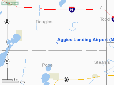
Location & QuickFacts
| FAA Information Effective: | 2008-09-25 |
| Airport Identifier: | MN04 |
| Airport Status: | Operational |
| Longitude/Latitude: | 095-15-46.1200W/45-46-24.8660N
-95.262811/45.773574 (Estimated) |
| Elevation: | 1387 ft / 422.76 m (Estimated) |
| Land: | 0 acres |
| From nearest city: | 8 nautical miles SE of Alexandria, MN |
| Location: | Douglas County, MN |
| Magnetic Variation: | 05E (1985) |
Owner & Manager
| Ownership: | Privately owned |
| Owner: | Art Engelbrecht |
| Address: | 12853 Engelbrecht Ln Se
Alexandria, MN 56308 |
| Phone number: | 612-763-7903 |
| Address: |
|
Airport Operations and Facilities
| Airport Use: | Private |
| Wind indicator: | Yes |
| Segmented Circle: | No |
| Control Tower: | No |
| Landing fee charge: | No |
| Sectional chart: | Twin Cities |
| Region: | AGL - Great Lakes |
| Boundary ARTCC: | ZMP - Minneapolis |
| Tie-in FSS: | PNM - Princeton |
| FSS on Airport: | No |
| FSS Toll Free: | 1-800-WX-BRIEF |
Airport Services
| Airframe Repair: | NONE |
| Power Plant Repair: | NONE |
Runway Information
Runway 17/35
| Dimension: | 1700 x 100 ft / 518.2 x 30.5 m |
| Surface: | TURF, |
| |
Runway 17 |
Runway 35 |
| Traffic Pattern: | Left | Left |
|
Radio Navigation Aids
| ID |
Type |
Name |
Ch |
Freq |
Var |
Dist |
| EE | NDB | Tamie | | 374.00 | 04E | 2.1 nm |
| GHW | NDB | Glenwood | | 346.00 | 03E | 8.1 nm |
| BBB | NDB | Benson | | 239.00 | 05E | 31.4 nm |
| LXL | NDB | Little Falls | | 359.00 | 03E | 40.0 nm |
| SAZ | NDB | Staples | | 257.00 | 04E | 41.3 nm |
| XCR | NDB | Ripley | | 404.00 | 03E | 42.6 nm |
| AQP | NDB | Appleton | | 356.00 | 05E | 45.4 nm |
| RYM | TACAN | Camp Ripley | 048X | | 03E | 42.5 nm |
| AXN | VOR/DME | Alexandria | 075X | 112.80 | 07E | 11.2 nm |
| MOX | VOR/DME | Morris | 033X | 109.60 | 05E | 32.2 nm |
| BDH | VOR/DME | Willmar | 84X | 113.70 | 04E | 39.8 nm |
| ILL | VOR/DME | Willmar | 084X | 113.70 | 04E | 40.1 nm |
| FFM | VOR/DME | Fergus Falls | 041X | 110.40 | 05E | 48.5 nm |
Images and information placed above are from
http://www.airport-data.com/airport/MN04/
We thank them for the data!
| General Info
|
| Country |
United States
|
| State |
MINNESOTA
|
| FAA ID |
MN04
|
| Latitude |
45-46-24.866N
|
| Longitude |
095-15-46.120W
|
| Elevation |
1387 feet
|
| Near City |
ALEXANDRIA
|
We don't guarantee the information is fresh and accurate. The data may
be wrong or outdated.
For more up-to-date information please refer to other sources.
|
|


