 |
|
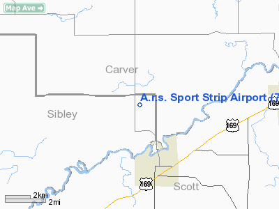
A.r.s. Sport Strip Airport |
Location & QuickFacts
| FAA Information Effective: | 2008-09-25 |
| Airport Identifier: | 7Y7 |
| Airport Status: | Closed Indefinitely |
| Longitude/Latitude: | 093-47-00.8650W/44-39-59.8660N
-93.783574/44.666629 (Estimated) |
| Elevation: | 955 ft / 291.08 m (Estimated) |
| Land: | 5 acres |
| From nearest city: | 3 nautical miles N of Belle Plaine, MN |
| Location: | Sibley County, MN |
| Magnetic Variation: | 04E (1985) |
Owner & Manager
| Ownership: | Privately owned |
| Owner: | Diane Minor |
| Address: | 25796 200th St
Belle Plaine, MN 56011-9305 |
| Phone number: | 612-873-5518 |
| Manager: | James Drometer |
| Address: | 25796 200th St
Belle Plaine, MN 56011-9305 |
| Phone number: | 612-873-6659 |
Airport Operations and Facilities
| Airport Use: | Open to public |
| Wind indicator: | Yes |
| Segmented Circle: | No |
| Control Tower: | No |
| Landing fee charge: | No |
| Sectional chart: | Twin Cities |
| Region: | AGL - Great Lakes |
| Boundary ARTCC: | ZMP - Minneapolis |
| Tie-in FSS: | PNM - Princeton |
| FSS on Airport: | No |
| FSS Toll Free: | 1-800-WX-BRIEF |
| NOTAMs Facility: | PNM (NOTAM-d service avaliable) |
Airport Communications
Airport Services
| Airframe Repair: | MAJOR |
| Power Plant Repair: | MAJOR |
Runway Information
Runway 18/36
| Dimension: | 2505 x 110 ft / 763.5 x 33.5 m |
| Surface: | TURF, Fair Condition
DIRT SHOWING THRU TURF. |
| |
Runway 18 |
Runway 36 |
| Longitude: | 093-47-00.8600W | 093-47-00.8600W |
| Latitude: | 44-40-12.3600N | 44-39-47.3800N |
| Elevation: | 950.00 ft | 955.00 ft |
| Traffic Pattern: | Left | Left |
| Displaced threshold: | 0.00 ft | 210.00 ft |
| Obstruction: | 33 ft road, 470.0 ft from runway, 150 ft left of centerline, 20:1 slope to clear | 81 ft trees, 1354.0 ft from runway, 20:1 slope to clear |
|
Radio Navigation Aids
| ID |
Type |
Name |
Ch |
Freq |
Var |
Dist |
| GYL | NDB | Glencoe | | 407.00 | 03E | 14.1 nm |
| HCD | NDB | Hutchinson | | 209.00 | 04E | 28.0 nm |
| MS | NDB | Narco | | 266.00 | 02E | 31.1 nm |
| ACQ | NDB | Waseca | | 371.00 | 02E | 37.2 nm |
| PPI | NDB | Hopey | | 400.00 | 03E | 38.0 nm |
| ULM | NDB/DME | New Ulm | 050X | 272.00 | 04E | 37.1 nm |
| FCM | VOR/DME | Flying Cloud | 055X | 111.80 | 06E | 16.9 nm |
| MSP | VOR/DME | Minneapolis | 100X | 115.30 | 02E | 27.1 nm |
| MKT | VOR/DME | Mankato | 045X | 110.80 | 07E | 27.4 nm |
| FOW | VOR/DME | Halfway | 049X | 111.20 | 02E | 33.0 nm |
| FGT | VORTAC | Farmington | 104X | 115.70 | 06E | 25.8 nm |
| GEP | VORTAC | Gopher | 120X | 117.30 | 06E | 33.7 nm |
| DWN | VORTAC | Darwin | 027X | 109.00 | 07E | 38.1 nm |
| MSP | VOT | Minneapolis St Paul | | 111.00 | | 27.6 nm |
| STP | VOT | St Paul | | 114.40 | | 35.0 nm |
Remarks
- ULTRALIGHT ACTIVITY ON & INVOF ARPT.
- (ARPT STATUS) ARPT CLSD INDEFLY.
Images and information placed above are from
http://www.airport-data.com/airport/7Y7/
We thank them for the data!
| General Info
|
| Country |
United States
|
| State |
MINNESOTA
|
| FAA ID |
7Y7
|
| Latitude |
44-39-59.866N
|
| Longitude |
093-47-00.865W
|
| Elevation |
955 feet
|
| Near City |
BELLE PLAINE
|
We don't guarantee the information is fresh and accurate. The data may
be wrong or outdated.
For more up-to-date information please refer to other sources.
|
|


