 |
|
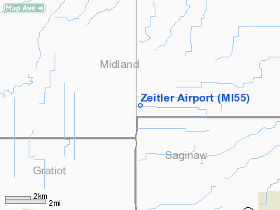
Location & QuickFacts
| FAA Information Effective: | 2008-09-25 |
| Airport Identifier: | MI55 |
| Airport Status: | Operational |
| Longitude/Latitude: | 084-21-54.9750W/43-29-24.1030N
-84.365271/43.490029 (Estimated) |
| Elevation: | 678 ft / 206.65 m (Estimated) |
| Land: | 3 acres |
| From nearest city: | 5 nautical miles NW of Merril, MI |
| Location: | Midland County, MI |
| Magnetic Variation: | 05W (1985) |
Owner & Manager
| Ownership: | Privately owned |
| Owner: | Wayne C. Zeitler |
| Address: | 4175 S Meridian
Merrill, MI 48637 |
| Phone number: | 517-643-7528 |
| Manager: | Wayne C. Zeitler |
| Address: | 4175 S Meridian
Merrill, MI 48637 |
| Phone number: | 517-643-7528 |
Airport Operations and Facilities
| Airport Use: | Private |
| Wind indicator: | Yes |
| Segmented Circle: | No |
| Control Tower: | No |
| Sectional chart: | Detroit |
| Region: | AGL - Great Lakes |
| Boundary ARTCC: | ZOB - Cleveland |
| Tie-in FSS: | LAN - Lansing |
| FSS Toll Free: | 1-800-WX-BRIEF |
Runway Information
Runway 09/27
| Dimension: | 2400 x 60 ft / 731.5 x 18.3 m |
| Surface: | TURF, Good Condition |
| |
Runway 09 |
Runway 27 |
| Traffic Pattern: | Left | Left |
|
Radio Navigation Aids
| ID |
Type |
Name |
Ch |
Freq |
Var |
Dist |
| AMN | NDB | Alma | | 329.00 | 05W | 20.9 nm |
| HYX | NDB | Browne | | 385.00 | 06W | 22.4 nm |
| GDW | NDB | Wiggins | | 209.00 | 04W | 29.2 nm |
| BHW | NDB | Hardwood | | 236.00 | 06W | 47.2 nm |
| MBS | VOR/DME | Saginaw | 076X | 112.90 | 03W | 12.8 nm |
| MOP | VOR/DME | Mount Pleasant | 043X | 110.60 | 05W | 18.1 nm |
| BXZ | VOR/DME | West Branch | 079X | 113.20 | 06W | 45.9 nm |
| FNT | VORTAC | Flint | 116X | 116.90 | 06W | 41.5 nm |
| LAN | VORTAC | Lansing | 045X | 110.80 | 05W | 48.7 nm |
Remarks
- PROVDD THAT OBSTRUCTIONS REMOVED/LOWERED TO GIVE A MIN 20:1 APCH CLNC AND 125 FT EITHER SIDE OF RY CNTRLN AND EXTENDING 240 FT BYD RY ENDS CLR OF OBSTRUCTIONS.
Images and information placed above are from
http://www.airport-data.com/airport/MI55/
We thank them for the data!
| General Info
|
| Country |
United States
|
| State |
MICHIGAN
|
| FAA ID |
MI55
|
| Latitude |
43-29-24.103N
|
| Longitude |
084-21-54.975W
|
| Elevation |
678 feet
|
| Near City |
MERRIL
|
We don't guarantee the information is fresh and accurate. The data may
be wrong or outdated.
For more up-to-date information please refer to other sources.
|
|


