 |
|
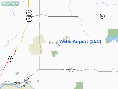
Location & QuickFacts
| FAA Information Effective: | 2008-09-25 |
| Airport Identifier: | 35C |
| Airport Status: | Operational |
| Longitude/Latitude: | 085-30-19.1060W/43-07-42.1010N
-85.505307/43.128361 (Estimated) |
| Elevation: | 890 ft / 271.27 m (Estimated) |
| Land: | 60 acres |
| From nearest city: | 3 nautical miles NE of Rockford, MI |
| Location: | Kent County, MI |
| Magnetic Variation: | 04W (1985) |
Owner & Manager
| Ownership: | Privately owned |
| Owner: | Terry Finger |
| Address: | 6530 11 Mile Road
Rockford, MI 49341 |
| Phone number: | 616-866-7055 |
| Manager: | Terry Finger |
| Address: | 6530 11 Mile Rd
Rockford, MI 49341 |
| Phone number: | 616-866-2546 |
Airport Operations and Facilities
| Airport Use: | Open to public |
| Wind indicator: | Yes |
| Segmented Circle: | Yes |
| Control Tower: | No |
| Landing fee charge: | No |
| Sectional chart: | Chicago |
| Region: | AGL - Great Lakes |
| Boundary ARTCC: | ZAU - Chicago |
| Tie-in FSS: | LAN - Lansing |
| FSS on Airport: | No |
| FSS Toll Free: | 1-800-WX-BRIEF |
| NOTAMs Facility: | LAN (NOTAM-d service avaliable) |
Airport Communications
Airport Services
| Airframe Repair: | NONE |
| Power Plant Repair: | NONE |
| Bottled Oxygen: | NONE |
| Bulk Oxygen: | NONE |
Runway Information
Runway 18/36
| Dimension: | 2200 x 100 ft / 670.6 x 30.5 m |
| Surface: | TURF, Good Condition |
| |
Runway 18 |
Runway 36 |
| Longitude: | 085-30-19.1000W | 085-30-19.1000W |
| Latitude: | 43-07-53.1600N | 43-07-31.0300N |
| Elevation: | 890.00 ft | 890.00 ft |
| Traffic Pattern: | Left | Left |
| Displaced threshold: | 0.00 ft | 400.00 ft |
| Runway End Identifier: | No | No |
| Centerline Lights: | No | No |
| Touchdown Lights: | No | No |
| Obstruction: | 15 ft tree, 2.0 ft from runway, 60 ft left of centerline
APCH RATIO 25:1 STRAIGHT OUT. | 40 ft tree, 30.0 ft from runway, 120 ft left of centerline
APCH RATIO 0:1 AT DSPLCD THLD BASED ON 60 FT TREES, 80R, 0 FT FM DSPLD THLD, 20:1 STRAIGHT OUT. |
|
Radio Navigation Aids
| ID |
Type |
Name |
Ch |
Freq |
Var |
Dist |
| AMN | NDB | Alma | | 329.00 | 05W | 33.6 nm |
| HLM | NDB | Holland | | 233.00 | 03W | 34.9 nm |
| BT | NDB | Batol | | 272.00 | 04W | 48.2 nm |
| GRR | VOR/DME | Grand Rapids | 106Y | 115.95 | 04W | 20.5 nm |
| HIC | VOR/DME | White Cloud | 123X | 117.60 | 01W | 28.4 nm |
| MOP | VOR/DME | Mount Pleasant | 043X | 110.60 | 05W | 44.8 nm |
| PMM | VOR/DME | Pullman | 058X | 112.10 | 00E | 47.8 nm |
| MKG | VORTAC | Muskegon | 099X | 115.20 | 01W | 23.5 nm |
| LAN | VORTAC | Lansing | 045X | 110.80 | 05W | 43.3 nm |
Remarks
Images and information placed above are from
http://www.airport-data.com/airport/35C/
We thank them for the data!
| General Info
|
| Country |
United States
|
| State |
MICHIGAN
|
| FAA ID |
35C
|
| Latitude |
43-07-42.101N
|
| Longitude |
085-30-19.106W
|
| Elevation |
890 feet
|
| Near City |
ROCKFORD
|
We don't guarantee the information is fresh and accurate. The data may
be wrong or outdated.
For more up-to-date information please refer to other sources.
|
|


