 |
|
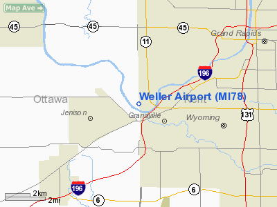
Location & QuickFacts
| FAA Information Effective: | 2008-09-25 |
| Airport Identifier: | MI78 |
| Airport Status: | Operational |
| Longitude/Latitude: | 085-47-00.1220W/42-55-00.0930N
-85.783367/42.916692 (Estimated) |
| Elevation: | 600 ft / 182.88 m (Estimated) |
| Land: | 0 acres |
| From nearest city: | 1 nautical miles NW of Grandville, MI |
| Location: | Ottawa County, MI |
| Magnetic Variation: | 03W (1985) |
Owner & Manager
| Ownership: | Privately owned |
| Owner: | Harry M. Weller |
| Address: | O-8335 Kenowa Sw
Grand Rapids, MI 49504 |
| Phone number: | 616-453-3117 |
| Manager: | Maynard Groendyke |
| Address: | 0-8335 Kenowa Sw
Grand Rapids, MI 49504 |
| Phone number: | 616-453-3117 |
Airport Operations and Facilities
| Airport Use: | Private |
| Wind indicator: | Yes |
| Segmented Circle: | No |
| Control Tower: | No |
| Landing fee charge: | No |
| Sectional chart: | Chicago |
| Region: | AGL - Great Lakes |
| Boundary ARTCC: | ZAU - Chicago |
| Tie-in FSS: | LAN - Lansing |
| FSS on Airport: | No |
| FSS Toll Free: | 1-800-WX-BRIEF |
Airport Services
| Airframe Repair: | NONE |
| Power Plant Repair: | NONE |
Runway Information
Runway 09/27
| Dimension: | 1700 x 100 ft / 518.2 x 30.5 m |
| Surface: | TURF, |
| |
Runway 09 |
Runway 27 |
| Traffic Pattern: | Left | Right |
| Obstruction: | 50 ft trees, 500.0 ft from runway | |
|
Radio Navigation Aids
| ID |
Type |
Name |
Ch |
Freq |
Var |
Dist |
| HLM | NDB | Holland | | 233.00 | 03W | 18.0 nm |
| BT | NDB | Batol | | 272.00 | 04W | 42.6 nm |
| GRR | VOR/DME | Grand Rapids | 106Y | 115.95 | 04W | 14.8 nm |
| PMM | VOR/DME | Pullman | 058X | 112.10 | 00E | 30.6 nm |
| HIC | VOR/DME | White Cloud | 123X | 117.60 | 01W | 39.7 nm |
| AZO | VOR/DME | Kalamazoo | 027X | 109.00 | 01W | 42.1 nm |
| ELX | VOR/DME | Keeler | 113X | 116.60 | 00E | 48.8 nm |
| MKG | VORTAC | Muskegon | 099X | 115.20 | 01W | 18.9 nm |
| BTL | VORTAC | Battle Creek | 031X | 109.40 | 02W | 43.4 nm |
| LAN | VORTAC | Lansing | 045X | 110.80 | 05W | 49.3 nm |
Images and information placed above are from
http://www.airport-data.com/airport/MI78/
We thank them for the data!
| General Info
|
| Country |
United States
|
| State |
MICHIGAN
|
| FAA ID |
MI78
|
| Latitude |
42-55-00.093N
|
| Longitude |
085-47-00.122W
|
| Elevation |
600 feet
|
| Near City |
GRANDVILLE
|
We don't guarantee the information is fresh and accurate. The data may
be wrong or outdated.
For more up-to-date information please refer to other sources.
|
|


