 |
|
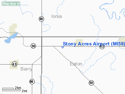
Location & QuickFacts
| FAA Information Effective: | 2008-09-25 |
| Airport Identifier: | MI58 |
| Airport Status: | Operational |
| Longitude/Latitude: | 085-01-42.9910W/42-45-16.1240N
-85.028609/42.754479 (Estimated) |
| Elevation: | 849 ft / 258.78 m (Surveyed) |
| Land: | 0 acres |
| From nearest city: | 2 nautical miles W of Sunfield, MI |
| Location: | Eaton County, MI |
| Magnetic Variation: | 04W (1985) |
Owner & Manager
| Ownership: | Privately owned |
| Owner: | R. Murray Hough |
| Address: | 4821 Delta River Dr
Lansing, MI 48906 |
| Phone number: | 517-321-2079 |
| Manager: | R. Murray Hough |
| Address: | 4821 Delta River Dr
Lansing, MI 48906 |
| Phone number: | 517-321-2079 |
Airport Operations and Facilities
| Airport Use: | Private |
| Wind indicator: | No |
| Segmented Circle: | No |
| Control Tower: | No |
| Landing fee charge: | No |
| Sectional chart: | Chicago |
| Region: | AGL - Great Lakes |
| Boundary ARTCC: | ZAU - Chicago |
| Tie-in FSS: | LAN - Lansing |
| FSS on Airport: | No |
| FSS Toll Free: | 1-800-WX-BRIEF |
Airport Services
| Airframe Repair: | MAJOR |
| Power Plant Repair: | MAJOR |
Runway Information
Runway 09/27
| Dimension: | 3300 x 50 ft / 1005.8 x 15.2 m |
| Surface: | GRVL-TRTD, |
| |
Runway 09 |
Runway 27 |
| Traffic Pattern: | Left | Left |
|
Radio Navigation Aids
| ID |
Type |
Name |
Ch |
Freq |
Var |
Dist |
| BT | NDB | Batol | | 272.00 | 04W | 24.6 nm |
| AMN | NDB | Alma | | 329.00 | 05W | 35.8 nm |
| OZW | NDB | Howell | | 243.00 | 05W | 46.6 nm |
| HLM | NDB | Holland | | 233.00 | 03W | 49.9 nm |
| GRR | VOR/DME | Grand Rapids | 106Y | 115.95 | 04W | 20.8 nm |
| AZO | VOR/DME | Kalamazoo | 027X | 109.00 | 01W | 38.8 nm |
| JXN | VOR/DME | Jackson | 033X | 109.60 | 05W | 39.0 nm |
| LFD | VOR/DME | Litchfield | 049X | 111.20 | 05W | 43.2 nm |
| LAN | VORTAC | Lansing | 045X | 110.80 | 05W | 14.8 nm |
| BTL | VORTAC | Battle Creek | 031X | 109.40 | 02W | 28.5 nm |
Images and information placed above are from
http://www.airport-data.com/airport/MI58/
We thank them for the data!
| General Info
|
| Country |
United States
|
| State |
MICHIGAN
|
| FAA ID |
MI58
|
| Latitude |
42-45-16.124N
|
| Longitude |
085-01-42.991W
|
| Elevation |
849 feet
|
| Near City |
SUNFIELD
|
We don't guarantee the information is fresh and accurate. The data may
be wrong or outdated.
For more up-to-date information please refer to other sources.
|
|


