 |
|
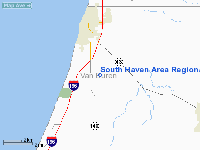
South Haven Area Regional Airport |
|
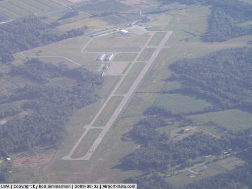 |
(Click on the photo to enlarge) |
Location & QuickFacts
| FAA Information Effective: | 2008-09-25 |
| Airport Identifier: | LWA |
| Airport Status: | Operational |
| Longitude/Latitude: | 086-15-20.3000W/42-21-04.3000N
-86.255639/42.351194 (Estimated) |
| Elevation: | 666 ft / 203.00 m (Surveyed) |
| Land: | 250 acres |
| From nearest city: | 3 nautical miles S of South Haven, MI |
| Location: | Van Buren County, MI |
| Magnetic Variation: | 03W (1985) |
Owner & Manager
| Ownership: | Publicly owned |
| Owner: | So Haven Area Rgnl Arpt Auth |
| Address: | 73020 County Rd 380
South Haven, MI 49090 |
| Phone number: | 269-637-7343 |
| Manager: | David W Johnson |
| Address: | 73020 County Rd 380
South Haven, MI 49090 |
| Phone number: | 269-637-7343 |
Airport Operations and Facilities
| Airport Use: | Open to public |
| Wind indicator: | Yes |
| Segmented Circle: | Yes |
| Control Tower: | No |
| Lighting Schedule: | DUSK-DAWN
MIRL RY 04/22 PRESET LOW INTST DUSK-2300; TO INCR INTST & ACTVT REIL & PAPI RYS 04 & 22 - CTAF. AFT 2300 ACTVT - CTAF. |
| Beacon Color: | Clear-Green (lighted land airport) |
| Landing fee charge: | No |
| Sectional chart: | Chicago |
| Region: | AGL - Great Lakes |
| Boundary ARTCC: | ZAU - Chicago |
| Tie-in FSS: | LAN - Lansing |
| FSS on Airport: | No |
| FSS Toll Free: | 1-800-WX-BRIEF |
| NOTAMs Facility: | LAN (NOTAM-d service avaliable) |
| Federal Agreements: | NGY |
Airport Communications
| CTAF: | 122.800 |
| Unicom: | 122.800 |
Airport Services
| Fuel available: | 100LLA |
| Airframe Repair: | MAJOR |
| Power Plant Repair: | MAJOR |
| Bottled Oxygen: | NONE |
| Bulk Oxygen: | NONE |
Runway Information
Runway 04/22
| Dimension: | 4801 x 75 ft / 1463.3 x 22.9 m |
| Surface: | ASPH, Good Condition |
| Weight Limit: | Single wheel: 12000 lbs. |
| Edge Lights: | Medium |
| |
Runway 04 |
Runway 22 |
| Longitude: | 086-15-36.1660W | 086-14-51.9229W |
| Latitude: | 42-20-52.2533N | 42-21-26.4846N |
| Elevation: | 652.00 ft | 666.00 ft |
| Alignment: | 44 | 127 |
| Traffic Pattern: | Left | Left |
| Markings: | Basic, Good Condition | Basic, Poor Condition |
| Crossing Height: | 33.00 ft | 28.00 ft |
| Displaced threshold: | 0.00 ft | 500.00 ft |
| VASI: | 4-light PAPI on left side | 4-light PAPI on left side |
| Visual Glide Angle: | 3.50° | 4.00° |
| Runway End Identifier: | Yes | Yes |
| Centerline Lights: | No | No |
| Touchdown Lights: | No | No |
| Obstruction: | 62 ft trees, 1463.0 ft from runway, 20:1 slope to clear | 90 ft trees, 1652.0 ft from runway, 126 ft right of centerline, 16:1 slope to clear
RWY 22 APCH RATIO AT DSPLD THLD 23:1. |
|
Runway 14/32
| Dimension: | 3275 x 190 ft / 998.2 x 57.9 m |
| Surface: | TURF, Fair Condition |
| |
Runway 14 |
Runway 32 |
| Longitude: | 086-15-45.6990W | 086-15-13.3980W |
| Latitude: | 42-21-07.8170N | 42-20-46.1180N |
| Alignment: | 127 | 127 |
| Traffic Pattern: | Left | Left |
| Displaced threshold: | 963.00 ft | 762.00 ft |
| Runway End Identifier: | No | No |
| Centerline Lights: | No | No |
| Touchdown Lights: | No | No |
| Obstruction: | 40 ft trees, 103L/ ft right of centerline
APCH RATIO 8:1 AT DSPLCD THLD BASED ON 27 FT TREES, 216 FT DST, 125L; 20:1 BASED ON STRAIGHT OUT. | 60 ft tree, 483.0 ft from runway, 8:1 slope to clear
RWY 32 APCH RATIO 20:1 AT DSPLCD THLD. |
|
Radio Navigation Aids
| ID |
Type |
Name |
Ch |
Freq |
Var |
Dist |
| HLM | NDB | Holland | | 233.00 | 03W | 27.1 nm |
| HAI | NDB | Three Rivers | | 407.00 | 02W | 37.9 nm |
| MGC | NDB | Michigan City | | 203.00 | 01W | 46.1 nm |
| BT | NDB | Batol | | 272.00 | 04W | 47.6 nm |
| IRS | NDB | Sturgis | | 382.00 | 04W | 48.9 nm |
| PMM | VOR/DME | Pullman | 058X | 112.10 | 00E | 9.6 nm |
| ELX | VOR/DME | Keeler | 113X | 116.60 | 00E | 13.8 nm |
| AZO | VOR/DME | Kalamazoo | 027X | 109.00 | 01W | 32.0 nm |
| GRR | VOR/DME | Grand Rapids | 106Y | 115.95 | 04W | 42.6 nm |
| GIJ | VORTAC | Gipper | 101X | 115.40 | 00E | 35.1 nm |
| BTL | VORTAC | Battle Creek | 031X | 109.40 | 02W | 44.7 nm |
Remarks
- DEER ON & INVOF ARPT.
- GCO AVBL ON FREQ 121.725 THRU FLT SVCS.
Images and information placed above are from
http://www.airport-data.com/airport/LWA/
We thank them for the data!
| General Info
|
| Country |
United States
|
| State |
MICHIGAN
|
| FAA ID |
LWA
|
| Latitude |
42-21-03.000N
|
| Longitude |
086-15-22.100W
|
| Elevation |
663 feet
|
| Near City |
SOUTH HAVEN
|
We don't guarantee the information is fresh and accurate. The data may
be wrong or outdated.
For more up-to-date information please refer to other sources.
|
|


