|
|
| Skyway Estates Airport |
| IATA: 60G – ICAO: K60G |
| Summary |
| Airport type |
Public |
| Operator |
Bud Cook |
| Location |
Eaton Rapids, Michigan |
| Elevation AMSL |
931 ft / 284 m |
| Coordinates |
42°35′01.131″N 84°39′04.932″W / 42.5836475°N 84.65137°W / 42.5836475; -84.65137Coordinates: 42°35′01.131″N 84°39′04.932″W / 42.5836475°N 84.65137°W / 42.5836475; -84.65137 |
| Runways |
| Direction |
Length |
Surface |
| ft |
m |
| 8/26 |
2,653 |
809 |
Turf |
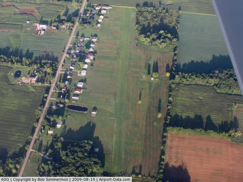
Skyway Estates Airport (IATA: 60G, ICAO: K60G) is a general aviation airport located north of Eaton Rapids in Eaton County, Michigan, USA. Facilities
Skyway Estates Airport has 1 runway. The airport is attended intermittently, and only during the day.
Runways
- Runway 8/26: 2,653 x 100 ft. (809 x 30 m), Surface: Turf
Transit
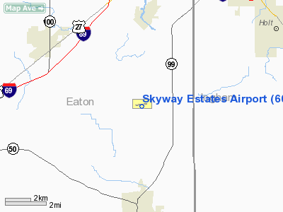
- The airport is accessible by road from Columbia Hwy, and is located approximately 1 mile west of M-99.
The above content comes from Wikipedia and is published under free licenses – click here to read more.
|
 |
(Click on the photo to enlarge) |
Location & QuickFacts
| FAA Information Effective: | 2008-09-25 |
| Airport Identifier: | 60G |
| Airport Status: | Operational |
| Longitude/Latitude: | 084-39-04.9320W/42-35-01.1310N
-84.651370/42.583647 (Estimated) |
| Elevation: | 931 ft / 283.77 m (Estimated) |
| Land: | 52 acres |
| From nearest city: | 4 nautical miles N of Eaton Rapids, MI |
| Location: | Eaton County, MI |
| Magnetic Variation: | 05W (1995) |
Owner & Manager
| Ownership: | Privately owned |
| Owner: | Skyway Estates Assn. Inc. |
| Address: | 9655 E. Columbia Hwy
Eaton Rapids, MI 48827 |
| Phone number: | 517-663-2471 |
| Manager: | Cleland 'bud' Cook |
| Address: | 9655 E. Columbia Hwy
Eaton Rapids, MI 48827 |
| Phone number: | 517-663-2471 |
Airport Operations and Facilities
| Airport Use: | Open to public |
| Wind indicator: | Yes |
| Segmented Circle: | Yes |
| Control Tower: | No |
| Lighting Schedule: | DUSK-DAWN
ACTVT MIRL RY 08/26 - CTAF. |
| Beacon Color: | Clear-Green (lighted land airport) |
| Landing fee charge: | No |
| Sectional chart: | Detroit |
| Region: | AGL - Great Lakes |
| Boundary ARTCC: | ZOB - Cleveland |
| Tie-in FSS: | LAN - Lansing |
| FSS on Airport: | No |
| FSS Toll Free: | 1-800-WX-BRIEF |
| NOTAMs Facility: | LAN (NOTAM-d service avaliable) |
Airport Communications
Airport Services
Runway Information
Runway 08/26
| Dimension: | 2653 x 100 ft / 808.6 x 30.5 m |
| Surface: | TURF, Good Condition |
| Edge Lights: | Medium |
| |
Runway 08 |
Runway 26 |
| Longitude: | 084-39-22.9300W | 084-38-47.7300W |
| Latitude: | 42-35-00.1300N | 42-35-03.2900N |
| Elevation: | 931.00 ft | 931.00 ft |
| Alignment: | 83 | 127 |
| Traffic Pattern: | Left | Left |
| Displaced threshold: | 685.00 ft | 200.00 ft |
| Obstruction: | 63 ft trees, 621.0 ft from runway, 10:1 slope to clear
RWY 08 APCH RATIO 20:1 AT DSPLCD THR. | 9 ft trees, 35.0 ft from runway, 30 ft left of centerline, 4:1 slope to clear
RWY 26 APCH RATIO AT DSPLCD THLD 20:1 OVER 28 FT TREE, 345 FT DSTC, 15 FT L. |
|
Radio Navigation Aids
| ID |
Type |
Name |
Ch |
Freq |
Var |
Dist |
| BT | NDB | Batol | | 272.00 | 04W | 27.1 nm |
| OZW | NDB | Howell | | 243.00 | 05W | 29.5 nm |
| AMN | NDB | Alma | | 329.00 | 05W | 44.9 nm |
| TCU | NDB | Tecumseh | | 239.00 | 04W | 47.5 nm |
| ADG | NDB | Adrian | | 278.00 | 06W | 49.9 nm |
| JXN | VOR/DME | Jackson | 033X | 109.60 | 05W | 21.3 nm |
| LFD | VOR/DME | Litchfield | 049X | 111.20 | 05W | 31.7 nm |
| GRR | VOR/DME | Grand Rapids | 106Y | 115.95 | 04W | 39.3 nm |
| AZO | VOR/DME | Kalamazoo | 027X | 109.00 | 01W | 45.1 nm |
| LAN | VORTAC | Lansing | 045X | 110.80 | 05W | 8.3 nm |
| BTL | VORTAC | Battle Creek | 031X | 109.40 | 02W | 31.3 nm |
| FNT | VORTAC | Flint | 116X | 116.90 | 06W | 46.1 nm |
| SVM | VORTAC | Salem | 090X | 114.30 | 03W | 48.0 nm |
| PSI | VORTAC | Pontiac | 047X | 111.00 | 03W | 50.0 nm |
Remarks
- VERIFY ARPT COND DURING WINTER & SPRING; CALL (517) 663-2471.
- AEROBATIC PRACTICE AREA IN 3 NM RADIUS OF ARPT DURING DAYLIGHT HRS; 1500 FT AGL TO 6000 FT MSL. CHECK WITH LANSING ATCT.
- AEROBATIC BOX N OF RY 08/26.
Images and information placed above are from
http://www.airport-data.com/airport/60G/
We thank them for the data!
| General Info
|
| Country |
United States
|
| State |
MICHIGAN
|
| FAA ID |
60G
|
| Latitude |
42-35-01.131N
|
| Longitude |
084-39-04.932W
|
| Elevation |
931 feet
|
| Near City |
EATON RAPIDS
|
We don't guarantee the information is fresh and accurate. The data may
be wrong or outdated.
For more up-to-date information please refer to other sources.
|
|