 |
|
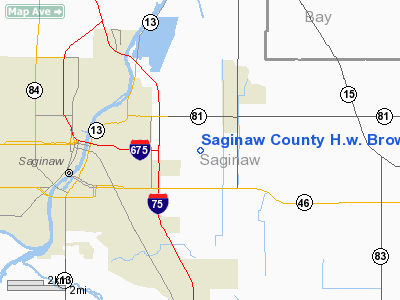
Saginaw County H.W. Browne Airport |
Location & QuickFacts
| FAA Information Effective: | 2008-09-25 |
| Airport Identifier: | HYX |
| Airport Status: | Operational |
| Longitude/Latitude: | 083-51-44.4000W/43-26-00.3000N
-83.862333/43.433417 (Estimated) |
| Elevation: | 601 ft / 183.18 m (Surveyed) |
| Land: | 293 acres |
| From nearest city: | 4 nautical miles E of Saginaw, MI |
| Location: | Saginaw County, MI |
| Magnetic Variation: | 04W (1980) |
Owner & Manager
| Ownership: | Publicly owned |
| Owner: | County Of Saginaw |
| Address: | 4821 Janes Road
Saginaw, MI 48601 |
| Phone number: | 989-758-2459 |
| Manager: | Alan Kaufman |
| Address: | 4821 Janes Rd
Saginaw, MI 48601 |
| Phone number: | 989-758-2459
AMGR PAGER 989-222-3677. |
Airport Operations and Facilities
| Airport Use: | Open to public |
| Wind indicator: | Yes |
| Segmented Circle: | Yes |
| Control Tower: | No |
| Lighting Schedule: | SS-SR
ACTVT MIRL RYS 05/23, 09/27, PAPI & REIL RY 09 & PAPI RYS 05, 23, 09 & 27 - CTAF. |
| Beacon Color: | Clear-Green (lighted land airport) |
| Landing fee charge: | No |
| Sectional chart: | Detroit |
| Region: | AGL - Great Lakes |
| Boundary ARTCC: | ZOB - Cleveland |
| Tie-in FSS: | LAN - Lansing |
| FSS on Airport: | No |
| FSS Toll Free: | 1-800-WX-BRIEF |
| NOTAMs Facility: | HYX (NOTAM-d service avaliable) |
| Federal Agreements: | NGY |
Airport Communications
| CTAF: | 122.800 |
| Unicom: | 122.800 |
Airport Services
| Fuel available: | 100LLA
24 HR SELF SERVE FUEL. |
| Airframe Repair: | MAJOR |
| Power Plant Repair: | MAJOR |
Runway Information
Runway 05/23
| Dimension: | 2951 x 60 ft / 899.5 x 18.3 m |
| Surface: | ASPH, Poor Condition
NUMEROUS TRANSVERSE AND LONGITUDINAL CRACKS. |
| Weight Limit: | Single wheel: 12500 lbs. |
| Edge Lights: | Medium |
| |
Runway 05 |
Runway 23 |
| Longitude: | 083-51-57.3560W | 083-51-29.2713W |
| Latitude: | 43-25-46.4650N | 43-26-07.2145N |
| Elevation: | 600.00 ft | 0.00 ft |
| Alignment: | 45 | 127 |
| Traffic Pattern: | Left | Left |
| Markings: | Basic, Poor Condition
RWY 5/23 MARKINGS FADED. | Basic, Poor Condition
RWY 5/23 MARKINGS FADED. |
| Crossing Height: | 25.00 ft | 25.00 ft |
| Displaced threshold: | 120.00 ft | 130.00 ft |
| VASI: | 2-light PAPI on left side | 2-light PAPI on left side |
| Visual Glide Angle: | 3.00° | 3.00° |
| Centerline Lights: | No | No |
| Touchdown Lights: | No | No |
| Obstruction: | 6 ft fence, 201.0 ft from runway
RWY 05 APCH RATIO 21:1 AT DSPLCD THR, +15 FT ROAD 328 FT DSTC. | 15 ft road, 279.0 ft from runway, 5:1 slope to clear
RWY 23 APCH RATIO 27:1 AT DSPLCD THLD. BASED ON 15 FT ROAD
RWY 23 HAS 2 FT HIGH CONCRETE CULVERT, 80 FT L, 100 FT FM RWY END & DITCH 15 FT DEEP ACROSS THE APCH END. |
|
Runway 09/27
| Dimension: | 5000 x 100 ft / 1524.0 x 30.5 m |
| Surface: | ASPH, Fair Condition
NUMEROUS TRANSVERSE AND LONGITUDINAL CRACKS. |
| Weight Limit: | Single wheel: 60000 lbs.
Dual wheel: 72000 lbs.
Dual tandem wheel: 101000 lbs. |
| Edge Lights: | Medium |
| |
Runway 09 |
Runway 27 |
| Longitude: | 083-52-18.7500W | 083-51-10.9750W |
| Latitude: | 43-26-02.0600N | 43-26-02.1180N |
| Elevation: | 599.00 ft | 598.00 ft |
| Alignment: | 90 | 127 |
| ILS Type: | | ILS/DME
|
| Traffic Pattern: | Left | Left |
| Markings: | Precision instrument, Good Condition | Precision instrument, Good Condition |
| Crossing Height: | 30.00 ft | 30.00 ft |
| VASI: | 2-light PAPI on left side | 2-light PAPI on left side |
| Visual Glide Angle: | 3.00° | 3.00° |
| Approach lights: | | MALSR |
| Runway End Identifier: | Yes | No |
| Centerline Lights: | No | No |
| Touchdown Lights: | No | No |
| Obstruction: | 89 ft pline, 3400.0 ft from runway, 35:1 slope to clear | , 50:1 slope to clear |
|
Radio Navigation Aids
| ID |
Type |
Name |
Ch |
Freq |
Var |
Dist |
| HYX | NDB | Browne | | 385.00 | 06W | 0.2 nm |
| AMN | NDB | Alma | | 329.00 | 05W | 40.9 nm |
| GDW | NDB | Wiggins | | 209.00 | 04W | 41.8 nm |
| OZW | NDB | Howell | | 243.00 | 05W | 48.4 nm |
| BHW | NDB | Hardwood | | 236.00 | 06W | 49.9 nm |
| MBS | VOR/DME | Saginaw | 076X | 112.90 | 03W | 11.1 nm |
| MOP | VOR/DME | Mount Pleasant | 043X | 110.60 | 05W | 39.8 nm |
| BAX | VOR/DME | Bad Axe | 019X | 108.20 | 05W | 43.7 nm |
| FNT | VORTAC | Flint | 116X | 116.90 | 06W | 28.5 nm |
| PSI | VORTAC | Pontiac | 047X | 111.00 | 03W | 46.3 nm |
Remarks
- BIRDS ON & INVOF ARPT.
- RY 23 HAS 2 FT HIGH CONCRETE CULVERT, 120 FT L, 20 FT FM RY END & DITCH 15 FT DEEP ACROSS THE APCH END, 120 FT L TO 21 FT R, 20 FT TO 197 FT FM RY END.
- GCO AVBL ON FREQ 121.725 THRU SAGINAW CD & FLT SVCS.
Images and information placed above are from
http://www.airport-data.com/airport/HYX/
We thank them for the data!
| General Info
|
| Country |
United States
|
| State |
MICHIGAN
|
| FAA ID |
HYX
|
| Latitude |
43-26-00.277N
|
| Longitude |
083-51-44.850W
|
| Elevation |
600 feet
|
| Near City |
SAGINAW
|
We don't guarantee the information is fresh and accurate. The data may
be wrong or outdated.
For more up-to-date information please refer to other sources.
|
|


