 |
|
Pellston Regional Airport Of Emmet County Airport |
Pellston Regional Airport
of Emmet County |
| IATA: PLN – ICAO: KPLN – FAA LID: PLN |
| Summary |
| Airport type |
Public |
| Owner |
Emmet County |
| Location |
Pellston, Michigan |
| Elevation AMSL |
720 ft / 219 m |
| Coordinates |
45°34′15″N 084°47′48″W / 45.57083°N 84.79667°W / 45.57083; -84.79667 |
| Website |
www.PellstonAirport.com |
| Runways |
| Direction |
Length |
Surface |
| ft |
m |
| 5/23 |
5,395 |
1,644 |
Asphalt |
| 14/32 |
6,512 |
1,985 |
Asphalt |
| Statistics (2009) |
| Total passengers |
46,219 ▼ 8% |
| Total enplanements |
23,444 ▼ 7% |
| Aircraft operations (2007) |
16,421 |
| Based aircraft (2007) |
36 |
| Sources: Federal Aviation Administration |
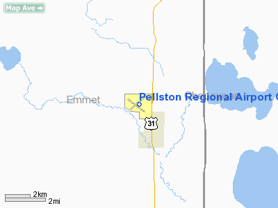
Pellston Regional Airport (IATA: PLN, ICAO: KPLN, FAA LID: PLN), also known as Pellston Regional Airport of Emmet County, is a public airport located one mile (2 km) northwest of the central business district of Pellston, a village in Emmet County, Michigan, United States.
It is mostly used for general aviation but also functions as the primary commercial airport for the sparsely populated northern tip of Michigan's Lower Peninsula, owing to its location halfway between the region's primary cities, Petoskey and Cheboygan, as well as its close proximity to the tourist centers of Mackinaw City and Mackinac Island. One commercial airline, Delta Air Lines, currently serves Pellston Regional with three departures and three arrivals daily.
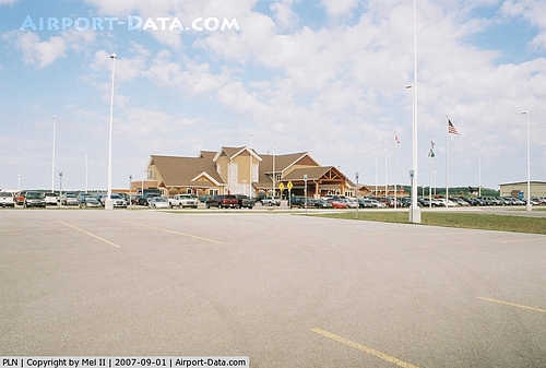
The main passenger terminal was extensively remodeled in a northern Michigan motif in 2003. Wireless internet service is available throughout the terminal at no charge to travelers. Facilities and aircraft
Pellston Regional Airport covers an area of 1,675 acres (678 ha) and contains two asphalt paved runways: 5/23 measuring 5,395 x 150 ft (1,644 x 46 m) and 14/32 measuring 6,512 x 150 ft (1,985 x 46 m).
For the 12-month period ending December 31, 2006, the airport had 16,421 aircraft operations, an average of 44 per day: 84% general aviation, 16% scheduled commercial and <1% military. There are 36 aircraft based at this airport: 89% single engine, 8% multi-engine and 3% jet aircraft.
Airlines and destinations
| Airlines |
Destinations |
| Delta Connection operated by Mesaba Airlines |
Detroit |
| Delta Connection operated by Pinnacle Airlines |
Detroit [seasonal] |
The above content comes from Wikipedia and is published under free licenses – click here to read more.
|
 |
(Click on the photo to enlarge) |
Location & QuickFacts
| FAA Information Effective: | 2008-09-25 |
| Airport Identifier: | PLN |
| Airport Status: | Operational |
| Longitude/Latitude: | 084-47-48.1740W/45-34-15.3390N
-84.796715/45.570928 (Estimated) |
| Elevation: | 720 ft / 219.46 m (Surveyed) |
| Land: | 1675 acres |
| From nearest city: | 1 nautical miles NW of Pellston, MI |
| Location: | Emmet County, MI |
| Magnetic Variation: | 06W (1985) |
Owner & Manager
| Ownership: | Publicly owned |
| Owner: | Emmet County |
| Address: | Us 31 N
Pellston, MI 49769 |
| Phone number: | 231-539-8441 |
| Manager: | Kelly Atkins |
| Address: | Us 31 N
Pellston, MI 49769 |
| Phone number: | 231-539-8441 |
Airport Operations and Facilities
| Airport Use: | Open to public |
| Wind indicator: | Yes |
| Segmented Circle: | Yes |
| Control Tower: | No |
| Lighting Schedule: | DUSK-DAWN
MIRL RY 05/23 & HIRL RY 14/32; REIL RYS 05; 14; 23 & MALSR RY 32 PRESET LOW INTST 0030-0500, AFT 0500 TO INCR INTST & ACTVT - CTAF |
| Beacon Color: | Clear-Green (lighted land airport) |
| Landing fee charge: | Yes
LNDG FEE WAIVED WITH FUEL PURCHASE. |
| Sectional chart: | Lake Huron |
| Region: | AGL - Great Lakes |
| Boundary ARTCC: | ZMP - Minneapolis |
| Tie-in FSS: | LAN - Lansing |
| FSS on Airport: | No |
| FSS Toll Free: | 1-800-WX-BRIEF |
| NOTAMs Facility: | PLN (NOTAM-d service avaliable) |
| Certification type/date: | I A S 05/1973
ARPT CLSD TO UNSKED ACR ACFT WITH MORE THAN 30 PSGR SEATS EXCP 24 HR PPR. |
| Federal Agreements: | NGY3 |
Airport Communications
| CTAF: | 123.000 |
| Unicom: | 123.000 |
Airport Services
| Fuel available: | 100LLA |
| Airframe Repair: | MAJOR |
| Power Plant Repair: | MAJOR |
| Bottled Oxygen: | NONE |
| Bulk Oxygen: | NONE |
Runway Information
Runway 05/23
| Dimension: | 5395 x 150 ft / 1644.4 x 45.7 m |
| Surface: | ASPH, Good Condition |
| Surface Treatment: | Saw-cut or plastic Grooved |
| Weight Limit: | Dual wheel: 65000 lbs.
Dual tandem wheel: 120000 lbs.
Dual dual tandem wheel: 200000 lbs. |
| Edge Lights: | Medium |
| |
Runway 05 |
Runway 23 |
| Longitude: | 084-48-09.9420W | 084-47-16.6030W |
| Latitude: | 45-34-02.6180N | 45-34-40.4740N |
| Elevation: | 710.00 ft | 720.00 ft |
| Alignment: | 45 | 127 |
| Traffic Pattern: | Left | Left |
| Markings: | Non-precision instrument, Fair Condition | Non-precision instrument, Fair Condition |
| Crossing Height: | 48.00 ft | 45.00 ft |
| VASI: | 4-box on right side | 4-box on left side |
| Visual Glide Angle: | 3.00° | 3.00° |
| Runway End Identifier: | Yes
& 23 REIL LCTD 100 FT FM THEIR RESPECTIVE APCH ENDS. | Yes |
| Centerline Lights: | No | No |
| Touchdown Lights: | No | No |
| Obstruction: | 50 ft trees, 1500.0 ft from runway, 300 ft right of centerline, 26:1 slope to clear | 18 ft road, 669.0 ft from runway, 316 ft right of centerline, 26:1 slope to clear |
|
Runway 14/32
| Dimension: | 6512 x 150 ft / 1984.9 x 45.7 m |
| Surface: | ASPH, Good Condition |
| Surface Treatment: | Saw-cut or plastic Grooved |
| Weight Limit: | Dual wheel: 65000 lbs.
Dual tandem wheel: 120000 lbs.
Dual dual tandem wheel: 200000 lbs. |
| Edge Lights: | High |
| |
Runway 14 |
Runway 32 |
| Longitude: | 084-48-24.8040W | 084-47-19.7250W |
| Latitude: | 45-34-32.7610N | 45-33-47.5520N |
| Elevation: | 718.00 ft | 707.00 ft |
| Alignment: | 127 | 127 |
| ILS Type: | | ILS
|
| Traffic Pattern: | Left | Left |
| Markings: | Precision instrument, Fair Condition | Precision instrument, Fair Condition |
| Crossing Height: | 52.00 ft | 0.00 ft |
| VASI: | 4-box on left side | |
| Visual Glide Angle: | 3.00° | 0.00° |
| Approach lights: | | MALSR |
| Runway End Identifier: | Yes | No |
| Centerline Lights: | No | No |
| Touchdown Lights: | No | No |
| Obstruction: | 82 ft trees, 2850.0 ft from runway, 32:1 slope to clear | 56 ft tree, 2739.0 ft from runway, 865 ft left of centerline, 45:1 slope to clear |
|
Radio Navigation Aids
| ID |
Type |
Name |
Ch |
Freq |
Var |
Dist |
| BFA | NDB | Boyne Falls | | 263.00 | 06W | 24.9 nm |
| CVX | NDB | Charlevoix | | 392.00 | 05W | 25.7 nm |
| SJX | NDB | St James | | 382.00 | 05W | 32.9 nm |
| PZQ | NDB | Rogers City | | 215.00 | 07W | 42.3 nm |
| CXK | NDB | Clam Lake | | 251.00 | 05W | 44.5 nm |
| CI | NDB | Koloe | | 400.00 | 06W | 47.0 nm |
| GYG | NDB | Grayling | | 359.00 | 06W | 49.4 nm |
| GLR | VOR/DME | Gaylord | 029X | 109.20 | 06W | 33.8 nm |
| PLN | VORTAC | Pellston | 055X | 111.80 | 06W | 6.6 nm |
Remarks
- DEER & GULLS OCNLY ON & INVOF ARPT.
- BE ALERT FOR SNOW REMOVAL EQUIP & ACTIVITY ON & INVOF RYS DURG WINTER MONTHS.
- TWY B1 & E1 CLSD 1 NOV THRU 15 APR..
Images and information placed above are from
http://www.airport-data.com/airport/PLN/
We thank them for the data!
| General Info
|
| Country |
United States
|
| State |
MICHIGAN
|
| FAA ID |
PLN
|
| Latitude |
45-34-15.339N
|
| Longitude |
084-47-48.174W
|
| Elevation |
720 feet
|
| Near City |
PELLSTON
|
We don't guarantee the information is fresh and accurate. The data may
be wrong or outdated.
For more up-to-date information please refer to other sources.
|
|


