|
|
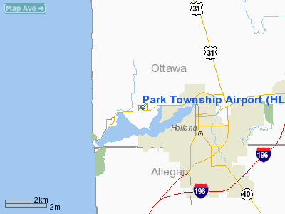
| Park Township Airport |
| IATA: HLM – ICAO: KHLM |
| Summary |
| Airport type |
Public |
| Operator |
Ottawa Aviation |
| Location |
Holland, Michigan |
| Elevation AMSL |
603 ft / 183.8 m |
| Coordinates |
42°47′45″N 86°09′43″W / 42.79583°N 86.16194°W / 42.79583; -86.16194Coordinates: 42°47′45″N 86°09′43″W / 42.79583°N 86.16194°W / 42.79583; -86.16194 |
| Runways |
| Direction |
Length |
Surface |
| ft |
m |
| 5/23 |
2,999 |
914 |
Asphalt |
| 12/30 |
2,245 |
684 |
Grass |
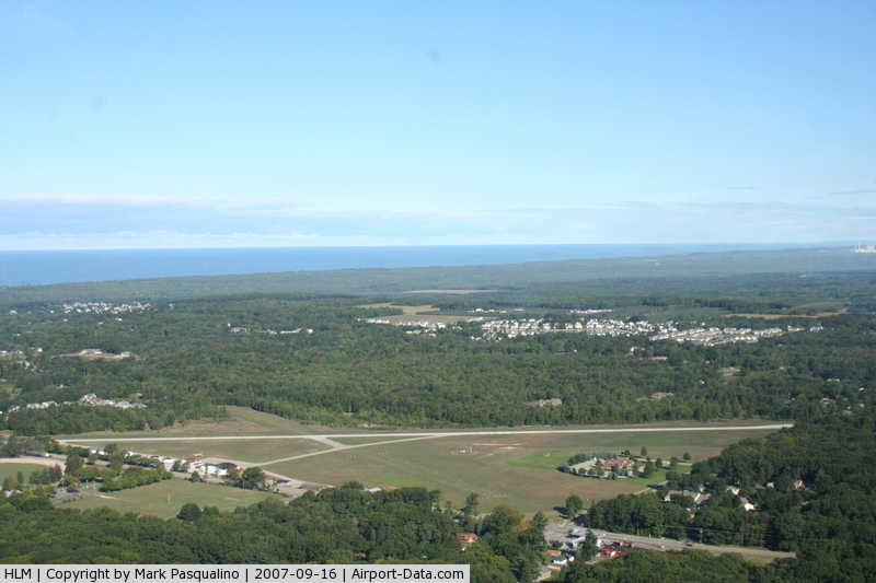
Park Township Airport (IATA: HLM, ICAO: KHLM, FAA LID: HLM) is a public airport located 3 mi (5 km) northwest of Holland, Michigan. Built in 1937, the airport is operated by Ottawa Aviation, an organization of local users whose aim is to promote the value of the airport to the surrounding community.
The airport has a main paved runway (5/23) and an intersecting grass runway (12/30).
The airport is used for general aviation and has no regularly scheduled commercial flights. It is quite popular with ultralight aircraft. The airport is also home to the Experimental Aircraft Association Chapter 1242.
The above content comes from Wikipedia and is published under free licenses – click here to read more.
|
 |
(Click on the photo to enlarge) |
Location & QuickFacts
| FAA Information Effective: | 2008-09-25 |
| Airport Identifier: | HLM |
| Airport Status: | Operational |
| Longitude/Latitude: | 086-09-43.1530W/42-47-45.2810N
-86.161987/42.795911 (Estimated) |
| Elevation: | 603 ft / 183.79 m (Surveyed) |
| Land: | 78 acres |
| From nearest city: | 3 nautical miles NW of Holland, MI |
| Location: | Ottawa County, MI |
| Magnetic Variation: | 03W (1985) |
Owner & Manager
| Ownership: | Publicly owned |
| Owner: | Park Township |
| Address: | Park Township Hall, 52 152nd Ave
Holland, MI 49424 |
| Phone number: | 616-399-4520 |
| Manager: | Brian L Fredrick |
| Address: | 1269 Ottawa Beach Road
Holland, MI 49424 |
| Phone number: | 616-566-7009 |
Airport Operations and Facilities
| Airport Use: | Open to public |
| Wind indicator: | Yes |
| Segmented Circle: | Yes |
| Control Tower: | No |
| Lighting Schedule: | DUSK-DAWN
ACTVT MIRL RY 05/23 - CTAF. |
| Beacon Color: | Clear-Green (lighted land airport) |
| Sectional chart: | Chicago |
| Region: | AGL - Great Lakes |
| Traffic Pattern Alt: | 800 ft |
| Boundary ARTCC: | ZAU - Chicago |
| Tie-in FSS: | LAN - Lansing |
| FSS on Airport: | No |
| FSS Toll Free: | 1-800-WX-BRIEF |
| NOTAMs Facility: | LAN (NOTAM-d service avaliable) |
Airport Communications
| CTAF: | 122.800 |
| Unicom: | 122.800 |
Airport Services
Runway Information
Runway 05/23
| Dimension: | 2999 x 50 ft / 914.1 x 15.2 m |
| Surface: | ASPH, Poor Condition
RWY MKG FADED. |
| Edge Lights: | Non-standard lighting system
NSTD MIRL; LGTS LCTD 24 FT FM RY EDGE. |
| |
Runway 05 |
Runway 23 |
| Longitude: | 086-09-57.8010W | 086-09-27.0020W |
| Latitude: | 42-47-37.2010N | 42-47-56.2540N |
| Elevation: | 603.00 ft | 602.00 ft |
| Alignment: | 50 | 127 |
| Traffic Pattern: | Left | Left |
| Markings: | Non-precision instrument, Fair Condition | Basic, Fair Condition |
| Displaced threshold: | 725.00 ft | 1142.00 ft |
| Runway End Identifier: | No | No |
| Centerline Lights: | No | No |
| Touchdown Lights: | No | No |
| Obstruction: | 15 ft road, 201.0 ft from runway, 150 ft left of centerline
RWY 05 APCH RATIO 11:1 AT DSPLCD THLD OVER 50 FT TREE, 550 FT DSTC, 140 R/L.
ROAD/FENCE/BIKE PATH & TREES ALL QUADS. | 67 ft trees, 201.0 ft from runway
APCH RATIO 3:1 AT DSPLCD THLD, 22 FT TREE, 66 FT DSTC, 133 FT R.
ROAD/FENCE/BIKE PATH /HOUSES & TREES ALL QUADS. |
|
Runway 12/30
| Dimension: | 2245 x 90 ft / 684.3 x 27.4 m |
| Surface: | TURF, Fair Condition
RWY MKG FADED. |
| |
Runway 12 |
Runway 30 |
| Longitude: | 086-09-58.1530W | 086-09-30.3660W |
| Latitude: | 42-47-47.3810N | 42-47-38.8390N |
| Alignment: | 113 | 127 |
| Traffic Pattern: | Left | Left |
| Displaced threshold: | 1019.00 ft | 820.00 ft |
| Runway End Identifier: | No | No |
| Centerline Lights: | No | No |
| Touchdown Lights: | No | No |
| Obstruction: | 63 ft trees, 70 ft right of centerline
APCH RATIO 17:1 AT DSPLCD THLD OVER 63 FT TREES, 1071 FT DSTC, 70 FT R. | 76 ft trees, 456.0 ft from runway, 110 ft right of centerline, 6:1 slope to clear
APCH RATIO 17:1 AT DSPLCD THLD, 76 FT TREES, 1,292 FT DSTC, 110 FT R. |
|
Radio Navigation Aids
| ID |
Type |
Name |
Ch |
Freq |
Var |
Dist |
| HLM | NDB | Holland | | 233.00 | 03W | 0.2 nm |
| PMM | VOR/DME | Pullman | 058X | 112.10 | 00E | 20.0 nm |
| GRR | VOR/DME | Grand Rapids | 106Y | 115.95 | 04W | 29.3 nm |
| ELX | VOR/DME | Keeler | 113X | 116.60 | 00E | 39.2 nm |
| AZO | VOR/DME | Kalamazoo | 027X | 109.00 | 01W | 43.1 nm |
| MKG | VORTAC | Muskegon | 099X | 115.20 | 01W | 23.1 nm |
| BTL | VORTAC | Battle Creek | 031X | 109.40 | 02W | 49.8 nm |
Remarks
- TREES IN TRANSITIONAL SURFACES BOTH SIDES OF RYS 05/23 & 12/30.
- DEP PROCEDURE: RY 5 AND 23, CLIMB STRAIGHT-OUT TO 1200 FT MSL BEFORE TURNING.
- RY 12/30 CLSD NOV 1 THRU MAR 31 & WHEN SNOW COVERED.
Images and information placed above are from
http://www.airport-data.com/airport/HLM/
We thank them for the data!
| General Info
|
| Country |
United States
|
| State |
MICHIGAN
|
| FAA ID |
HLM
|
| Latitude |
42-47-45.281N
|
| Longitude |
086-09-43.153W
|
| Elevation |
603 feet
|
| Near City |
HOLLAND
|
We don't guarantee the information is fresh and accurate. The data may
be wrong or outdated.
For more up-to-date information please refer to other sources.
|
|