 |
|
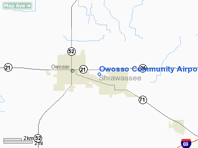
Location & QuickFacts
| FAA Information Effective: | 2008-09-25 |
| Airport Identifier: | RNP |
| Airport Status: | Operational |
| Longitude/Latitude: | 084-08-18.5461W/42-59-34.6648N
-84.138485/42.992962 (Estimated) |
| Elevation: | 736 ft / 224.33 m (Surveyed) |
| Land: | 279 acres |
| From nearest city: | 2 nautical miles E of Owosso, MI |
| Location: | Shiawassee County, MI |
| Magnetic Variation: | 06W (2000) |
Owner & Manager
| Ownership: | Publicly owned |
| Owner: | Shiawassee Airport Board |
| Address: | 205 Airport Drive
Owosso, MI 48867 |
| Phone number: | 989-725-1969 |
| Manager: | Gregory Cochran |
| Address: | 205 Airport Drive
Owosso, MI 48867 |
| Phone number: | 989-725-1969
ARPT OUTSIDE PHONE 989-723-9887. |
Airport Operations and Facilities
| Airport Use: | Open to public |
| Wind indicator: | Yes |
| Segmented Circle: | Yes |
| Control Tower: | No |
| Lighting Schedule: | DUSK-DAWN
ACTVT MIRL RY 10/28, PAPI RY 10 & 28, & REIL RY 10 &28 - CTAF. |
| Beacon Color: | Clear-Green (lighted land airport) |
| Landing fee charge: | No |
| Sectional chart: | Detroit |
| Region: | AGL - Great Lakes |
| Boundary ARTCC: | ZOB - Cleveland |
| Tie-in FSS: | LAN - Lansing |
| FSS on Airport: | No |
| FSS Toll Free: | 1-800-WX-BRIEF |
| NOTAMs Facility: | RNP (NOTAM-d service avaliable) |
| Federal Agreements: | NGY |
Airport Communications
| CTAF: | 123.000 |
| Unicom: | 123.000 |
Airport Services
| Fuel available: | 100LL |
| Airframe Repair: | MAJOR |
| Power Plant Repair: | MAJOR |
| Bottled Oxygen: | NONE |
| Bulk Oxygen: | NONE |
Runway Information
Runway 06/24
| Dimension: | 2483 x 130 ft / 756.8 x 39.6 m |
| Surface: | TURF, Good Condition
RY 10/28 HAS NUMEROUS CRACKS. |
| |
Runway 06 |
Runway 24 |
| Longitude: | 084-08-37.4000W | 084-08-08.9000W |
| Latitude: | 42-59-31.3000N | 42-59-44.1000N |
| Alignment: | 58 | 127 |
| Traffic Pattern: | Left | Left |
| Displaced threshold: | 1057.00 ft | 0.00 ft |
| Obstruction: | 50 ft trees, 72.0 ft from runway, 120 ft right of centerline, 1:1 slope to clear
RWY 06 STRAIGHT OUT APCH RATIO 20:1 AT DSPLCD THLD | 32 ft pole, 576.0 ft from runway, 96 ft right of centerline, 18:1 slope to clear |
|
Runway 10/28
| Dimension: | 4300 x 100 ft / 1310.6 x 30.5 m |
| Surface: | ASPH, Good Condition
RY 10/28 HAS NUMEROUS CRACKS. |
| Weight Limit: | Single wheel: 18000 lbs. |
| Edge Lights: | Medium |
| |
Runway 10 |
Runway 28 |
| Longitude: | 084-08-48.3387W | 084-07-51.8937W |
| Latitude: | 42-59-39.3014N | 42-59-29.9861N |
| Elevation: | 733.00 ft | 736.00 ft |
| Alignment: | 103 | 127 |
| Traffic Pattern: | Left | Left |
| Markings: | Non-precision instrument, Good Condition | Non-precision instrument, Good Condition |
| Crossing Height: | 20.00 ft | 20.00 ft |
| VASI: | 4-light PAPI on left side | 4-light PAPI on left side |
| Visual Glide Angle: | 3.00° | 4.00° |
| Runway End Identifier: | Yes | Yes |
| Obstruction: | 57 ft trees, 800.0 ft from runway, 100 ft left of centerline, 10:1 slope to clear | 90 ft trees, 2000.0 ft from runway, 100 ft left of centerline, 20:1 slope to clear |
|
Runway 18/36
| Dimension: | 2599 x 260 ft / 792.2 x 79.2 m |
| Surface: | TURF, Good Condition
RY 10/28 HAS NUMEROUS CRACKS. |
| |
Runway 18 |
Runway 36 |
| Longitude: | 084-08-12.9000W | 084-08-10.2000W |
| Latitude: | 42-59-44.6000N | 42-59-19.0000N |
| Alignment: | 127 | 127 |
| Traffic Pattern: | Left | Left |
| Markings: | None, | , |
| Displaced threshold: | 396.00 ft | 990.00 ft |
| Obstruction: | 28 ft bldg, 342.0 ft from runway, 126 ft left of centerline, 12:1 slope to clear
RWY 18 APCH RATIO 20:1 AT DSPLCD THLD, + 42 FT TREES 1050 FT DSTC. | 75 ft trees, 30.0 ft from runway, 131 ft right of centerline
RWY 36 APCH RATIO 16:1 TO DSPLCD THLD; +60 FT TREES 1018 FT DSTC. |
|
Radio Navigation Aids
| ID |
Type |
Name |
Ch |
Freq |
Var |
Dist |
| OZW | NDB | Howell | | 243.00 | 05W | 22.6 nm |
| HYX | NDB | Browne | | 385.00 | 06W | 29.1 nm |
| AMN | NDB | Alma | | 329.00 | 05W | 34.6 nm |
| MBS | VOR/DME | Saginaw | 076X | 112.90 | 03W | 32.5 nm |
| MOP | VOR/DME | Mount Pleasant | 043X | 110.60 | 05W | 46.0 nm |
| JXN | VOR/DME | Jackson | 033X | 109.60 | 05W | 46.3 nm |
| FNT | VORTAC | Flint | 116X | 116.90 | 06W | 17.3 nm |
| LAN | VORTAC | Lansing | 045X | 110.80 | 05W | 29.7 nm |
| PSI | VORTAC | Pontiac | 047X | 111.00 | 03W | 32.0 nm |
| SVM | VORTAC | Salem | 090X | 114.30 | 03W | 42.6 nm |
Remarks
- DEER & BIRDS ON & INVOF ARPT.
- GCO AVBL ON FREQ 121.725 THRU FNT CD & FLT SVCS.
Images and information placed above are from
http://www.airport-data.com/airport/RNP/
We thank them for the data!
| General Info
|
| Country |
United States
|
| State |
MICHIGAN
|
| FAA ID |
RNP
|
| Time |
UTC-5(-4DT)
|
| Latitude |
42.992973
42° 59' 34.70" N
|
| Longitude |
-84.138914
084° 08' 20.09" W
|
| Elevation |
736 feet
224 meters
|
| Type |
Civil
|
| Magnetic Variation |
006° W (01/06)
|
| Beacon |
Yes
|
| Operating Agency |
U.S.CIVIL AIRPORT WHEREIN PERMIT COVERS USE BY TRANSIT MILITARY AIRCRAFT
|
| Operating Hours |
SEE REMARKS FOR OPERATING HOURS OR COMMUNICATIONS FOR POSSIBLE HOURS
|
| Daylight Saving Time |
Second Sunday in March at 0200 to first Sunday in November at 0200 local time (Exception Arizona and that portion of Indiana in the Eastern Time Zone)
|
We don't guarantee the information is fresh and accurate. The data may
be wrong or outdated.
For more up-to-date information please refer to other sources.
|
|


