|
|
|
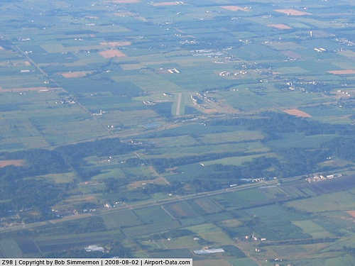 |
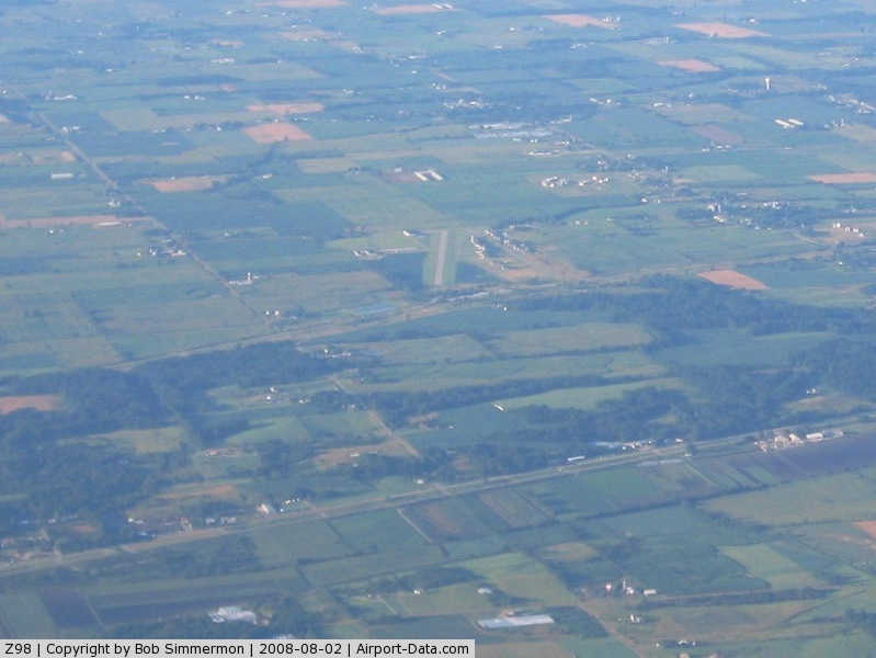
(Click on the photo to enlarge) |
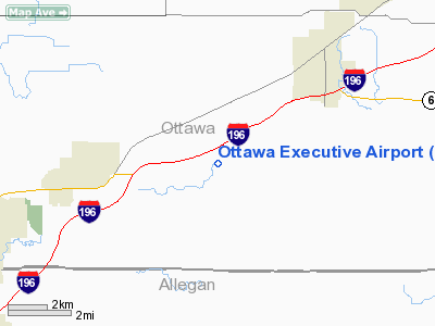
Location & QuickFacts
| FAA Information Effective: | 2008-09-25 |
| Airport Identifier: | Z98 |
| Airport Status: | Operational |
| Longitude/Latitude: | 085-55-41.1320W/42-49-02.0920N
-85.928092/42.817248 (Estimated) |
| Elevation: | 740 ft / 225.55 m (Surveyed) |
| Land: | 100 acres |
| From nearest city: | 3 nautical miles E of Zeeland, MI |
| Location: | Ottawa County, MI |
| Magnetic Variation: | 03W (1990) |
Owner & Manager
| Ownership: | Privately owned |
| Owner: | Php, Inc C/o Randy Pugh |
| Address: | 5923 Byron Road
Zeeland, MI 49464 |
| Phone number: | 616-772-5970 |
| Manager: | Randy Pugh |
| Address: | Php Inc, 5923 Byron Road
Zeeland, MI 49464 |
| Phone number: | 616-772-1096 |
Airport Operations and Facilities
| Airport Use: | Open to public |
| Wind indicator: | Yes |
| Segmented Circle: | Yes |
| Control Tower: | No |
| Lighting Schedule: | RDO-CTL
ACTVT LIRL RY 02/20 - CTAF. 5 CLICKS ON SS-SR. |
| Sectional chart: | Chicago |
| Region: | AGL - Great Lakes |
| Boundary ARTCC: | ZAU - Chicago |
| Tie-in FSS: | LAN - Lansing |
| FSS Toll Free: | 1-800-WX-BRIEF |
| NOTAMs Facility: | LAN (NOTAM-d service avaliable) |
Airport Communications
Airport Services
| Fuel available: | 100LL |
| Airframe Repair: | MAJOR |
| Power Plant Repair: | MAJOR |
Runway Information
Runway 02/20
| Dimension: | 3800 x 60 ft / 1158.2 x 18.3 m |
| Surface: | ASPH, Good Condition |
| Edge Lights: | Low |
| |
Runway 02 |
Runway 20 |
| Traffic Pattern: | Left | Left |
| Markings: | Basic, Good Condition | Basic, Good Condition |
| Displaced threshold: | 294.00 ft | 191.00 ft |
| Obstruction: | , 50:1 slope to clear
APCH RATIO 26:1 AT DSPLCD THR BASED ON +16 FT RD; 425 FT FM DSPLCD THR.
CLOSE IN OBSTN +16 FT ROAD; 125 FT FM RY END; +8 FT CROPS DURING LATE SUMMER MONTHS. | 50 ft pole, 900.0 ft from runway, 100 ft right of centerline, 14:1 slope to clear
APCH RATIO 21:1 AT DSPLCD THLD. |
| Decleard distances: | Take off run available 3609.00 ft
Take off distance available 3800.00 ft
Actual stop distance available 3609.00 ft
Landing distance available 3315.00 ft
| Take off run available 3506.00 ft
Take off distance available 3800.00 ft
Actual stop distance available 3590.00 ft
Landing distance available 3399.00 ft
|
|
Radio Navigation Aids
| ID |
Type |
Name |
Ch |
Freq |
Var |
Dist |
| HLM | NDB | Holland | | 233.00 | 03W | 10.2 nm |
| BT | NDB | Batol | | 272.00 | 04W | 42.8 nm |
| GRR | VOR/DME | Grand Rapids | 106Y | 115.95 | 04W | 19.1 nm |
| PMM | VOR/DME | Pullman | 058X | 112.10 | 00E | 22.5 nm |
| AZO | VOR/DME | Kalamazoo | 027X | 109.00 | 01W | 38.6 nm |
| ELX | VOR/DME | Keeler | 113X | 116.60 | 00E | 41.4 nm |
| HIC | VOR/DME | White Cloud | 123X | 117.60 | 01W | 46.5 nm |
| MKG | VORTAC | Muskegon | 099X | 115.20 | 01W | 21.7 nm |
| BTL | VORTAC | Battle Creek | 031X | 109.40 | 02W | 42.7 nm |
Remarks
- RY SLOPES 'UP' FM S TO N.
- 200 FT LGTD ANT APRXLY 1900 FT NE OF RY 20.
- SEE AIRSPACE LTR DATED 3/7/94.
Images and information placed above are from
http://www.airport-data.com/airport/Z98/
We thank them for the data!
| General Info
|
| Country |
United States
|
| State |
MICHIGAN
|
| FAA ID |
Z98
|
| Latitude |
42-49-02.092N
|
| Longitude |
085-55-41.132W
|
| Elevation |
740 feet
|
| Near City |
ZEELAND
|
We don't guarantee the information is fresh and accurate. The data may
be wrong or outdated.
For more up-to-date information please refer to other sources.
|
|