 |
|
|
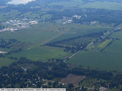 |
(Click on the photo to enlarge) |
|
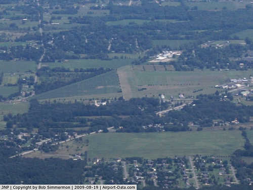 |
(Click on the photo to enlarge) |
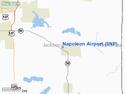
Location & QuickFacts
| FAA Information Effective: | 2008-09-25 |
| Airport Identifier: | 3NP |
| Airport Status: | Operational |
| Longitude/Latitude: | 084-15-34.8240W/42-10-15.1380N
-84.259673/42.170872 (Estimated) |
| Elevation: | 963 ft / 293.52 m (Surveyed) |
| Land: | 95 acres |
| From nearest city: | 1 nautical miles NW of Napoleon, MI |
| Location: | Jackson County, MI |
| Magnetic Variation: | 05W (1985) |
Owner & Manager
| Ownership: | Privately owned |
| Owner: | Anthony Hurst |
| Address: | 1600 Hatch Rd
Jackson, MI 49201 |
| Phone number: | 517-563-5353 |
| Manager: | Anthony 'tony' Hurst |
| Address: | 1600 Hatch Rd
Jackson, MI 49201 |
| Phone number: | 517-474-7444 |
Airport Operations and Facilities
| Airport Use: | Open to public |
| Wind indicator: | Yes |
| Segmented Circle: | Yes |
| Control Tower: | No |
| Landing fee charge: | No |
| Sectional chart: | Detroit |
| Region: | AGL - Great Lakes |
| Boundary ARTCC: | ZOB - Cleveland |
| Tie-in FSS: | LAN - Lansing |
| FSS on Airport: | No |
| FSS Toll Free: | 1-800-WX-BRIEF |
| NOTAMs Facility: | LAN (NOTAM-d service avaliable) |
Airport Communications
Airport Services
| Airframe Repair: | MINOR |
| Power Plant Repair: | MINOR |
| Bottled Oxygen: | NONE |
| Bulk Oxygen: | NONE |
Runway Information
Runway 09/27
| Dimension: | 2740 x 200 ft / 835.2 x 61.0 m |
| Surface: | TURF, Fair Condition |
| |
Runway 09 |
Runway 27 |
| Longitude: | 084-15-47.4300W | 084-15-13.2300W |
| Latitude: | 42-10-17.0800N | 42-10-17.0700N |
| Elevation: | 963.00 ft | 963.00 ft |
| Traffic Pattern: | Left | Left |
| Displaced threshold: | 1200.00 ft | 0.00 ft |
| Obstruction: | 15 ft road, 20.0 ft from runway, 1:1 slope to clear
RWY 09 APCH RATIO TO DSPLCD THLD 18:1 BASED ON +88 FT TREES 1587 FT DSTC. | 52 ft trees, 1200.0 ft from runway, 23:1 slope to clear |
|
Runway 15/33
| Dimension: | 2500 x 160 ft / 762.0 x 48.8 m |
| Surface: | TURF, Fair Condition |
| |
Runway 15 |
Runway 33 |
| Longitude: | 084-15-46.3200W | 084-15-31.1400W |
| Latitude: | 42-10-23.6100N | 42-10-01.6600N |
| Elevation: | 963.00 ft | 963.00 ft |
| Traffic Pattern: | Left | Left |
| Displaced threshold: | 290.00 ft | 550.00 ft |
| Obstruction: | 15 ft road, 90 ft right of centerline
RWY 15 RWY 15 APCH RATIO AT DSPLCD THLD 10:1 OVER 24 FT TREE, 240 FT DSTC, 104 FT R. | 40 ft trees, 400.0 ft from runway, 10:1 slope to clear
APCH RATIO 20:1 AT DSPLCD THLD BASED ON +72 FT TREE 1440 FT DSTC, 0B |
|
Radio Navigation Aids
| ID |
Type |
Name |
Ch |
Freq |
Var |
Dist |
| TCU | NDB | Tecumseh | | 239.00 | 04W | 18.7 nm |
| ADG | NDB | Adrian | | 278.00 | 06W | 19.8 nm |
| OZW | NDB | Howell | | 243.00 | 05W | 30.3 nm |
| USE | NDB | Fulton | | 375.00 | 05W | 34.2 nm |
| BYN | NDB | Bryan | | 260.00 | 04W | 42.6 nm |
| BT | NDB | Batol | | 272.00 | 04W | 42.7 nm |
| ANQ | NDB | Angola | | 347.00 | 05W | 48.9 nm |
| RYS | NDB | Grosse Ile | | 419.00 | 06W | 49.5 nm |
| TOL | TACAN | Toledo | 072X | | 05W | 40.3 nm |
| JXN | VOR/DME | Jackson | 033X | 109.60 | 05W | 10.3 nm |
| LFD | VOR/DME | Litchfield | 049X | 111.20 | 05W | 23.5 nm |
| DXO | VOR/DME | Detroit | 081X | 113.40 | 06W | 39.9 nm |
| SVM | VORTAC | Salem | 090X | 114.30 | 03W | 32.9 nm |
| CRL | VORTAC | Carleton | 104X | 115.70 | 03W | 36.5 nm |
| LAN | VORTAC | Lansing | 045X | 110.80 | 05W | 38.2 nm |
| BTL | VORTAC | Battle Creek | 031X | 109.40 | 02W | 45.0 nm |
| PSI | VORTAC | Pontiac | 047X | 111.00 | 03W | 45.3 nm |
| YIP | VOT | Willow Run | | 112.00 | | 33.0 nm |
| DTW | VOT | Detroit Met Wayne | | 109.80 | | 40.0 nm |
Remarks
- OIL TANKS SOUTH OF ARPT.
- ULTRALIGHT OPNS IN GRASS WEST OF RY 15/33.
- EXISTED PRIOR TO 1959.
Images and information placed above are from
http://www.airport-data.com/airport/3NP/
We thank them for the data!
| General Info
|
| Country |
United States
|
| State |
MICHIGAN
|
| FAA ID |
3NP
|
| Latitude |
42-10-15.138N
|
| Longitude |
084-15-34.824W
|
| Elevation |
963 feet
|
| Near City |
NAPOLEON
|
We don't guarantee the information is fresh and accurate. The data may
be wrong or outdated.
For more up-to-date information please refer to other sources.
|
|


