|
|
|
 |
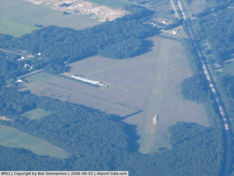
(Click on the photo to enlarge) |
Location & QuickFacts
| FAA Information Effective: | 2008-09-25 |
| Airport Identifier: | 8MI3 |
| Airport Status: | Operational |
| Longitude/Latitude: | 085-48-20.0320W/42-11-45.1430N
-85.805564/42.195873 (Estimated) |
| Elevation: | 830 ft / 252.98 m (Estimated) |
| Land: | 96 acres |
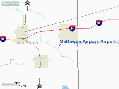
| From nearest city: | 1 nautical miles SW of Mattawan, MI |
| Location: | Van Buren County, MI |
| Magnetic Variation: | 03W (1985) |
Owner & Manager
| Ownership: | Privately owned |
| Owner: | John K. Bosker |
| Address: | 26141 60th Avenue
Mattawan, MI 49071 |
| Phone number: | 616-668-3830 |
| Manager: | John K. Bosker |
| Address: | 26141 60th Avenue
Mattawan, MI 49071 |
| Phone number: | 616-668-3830 |
Airport Operations and Facilities
| Airport Use: | Private |
| Wind indicator: | Yes |
| Segmented Circle: | No |
| Control Tower: | No |
| Landing fee charge: | No |
| Sectional chart: | Chicago |
| Region: | AGL - Great Lakes |
| Traffic Pattern Alt: | 800 ft |
| Boundary ARTCC: | ZAU - Chicago |
| Tie-in FSS: | LAN - Lansing |
| FSS on Airport: | No |
| FSS Toll Free: | 1-800-WX-BRIEF
OR LOCAL CALL 343-2608. |
Airport Services
| Airframe Repair: | MAJOR |
| Power Plant Repair: | MAJOR |
Runway Information
Runway 05/23
| Dimension: | 2000 x 100 ft / 609.6 x 30.5 m |
| Surface: | TURF, Fair Condition |
| |
Runway 05 |
Runway 23 |
| Traffic Pattern: | Left | Left |
| Obstruction: | 40 ft trees, 1025.0 ft from runway, 18:1 slope to clear | 60 ft trees, 1280.0 ft from runway, 8:1 slope to clear
+50' TREES 50' LEFT. |
|
Radio Navigation Aids
| ID |
Type |
Name |
Ch |
Freq |
Var |
Dist |
| HAI | NDB | Three Rivers | | 407.00 | 02W | 17.2 nm |
| IRS | NDB | Sturgis | | 382.00 | 04W | 28.4 nm |
| BT | NDB | Batol | | 272.00 | 04W | 29.4 nm |
| HLM | NDB | Holland | | 233.00 | 03W | 39.3 nm |
| ANQ | NDB | Angola | | 347.00 | 05W | 46.4 nm |
| AZO | VOR/DME | Kalamazoo | 027X | 109.00 | 01W | 11.5 nm |
| ELX | VOR/DME | Keeler | 113X | 116.60 | 00E | 14.5 nm |
| PMM | VOR/DME | Pullman | 058X | 112.10 | 00E | 21.0 nm |
| GRR | VOR/DME | Grand Rapids | 106Y | 115.95 | 04W | 38.1 nm |
| LFD | VOR/DME | Litchfield | 049X | 111.20 | 05W | 47.1 nm |
| BTL | VORTAC | Battle Creek | 031X | 109.40 | 02W | 25.5 nm |
| GIJ | VORTAC | Gipper | 101X | 115.40 | 00E | 34.4 nm |
| GSH | VORTAC | Goshen | 084X | 113.70 | 00E | 41.5 nm |
Remarks
- E111: PVT USE ONLY; ESTABLISH AN AGREEMENT WITH KIRBY ARPT REGARDING TFC PAT OPNS OF BOTH ARPTS TO OPERATE AS ONE.
Images and information placed above are from
http://www.airport-data.com/airport/8MI3/
We thank them for the data!
| General Info
|
| Country |
United States
|
| State |
MICHIGAN
|
| FAA ID |
8MI3
|
| Latitude |
42-11-45.143N
|
| Longitude |
085-48-20.032W
|
| Elevation |
830 feet
|
| Near City |
MATTAWAN
|
We don't guarantee the information is fresh and accurate. The data may
be wrong or outdated.
For more up-to-date information please refer to other sources.
|
|