|
|
Coordinates: 43°57′45″N 086°24′28″W / 43.9625°N 86.40778°W / 43.9625; -86.40778
| Mason County Airport |
| IATA: LDM – ICAO: KLDM – FAA LID: LDM |
| Summary |
| Airport type |
Public |
| Owner |
Mason County |
| Serves |
Ludington |
| Location |
Ludington, Michigan |
| Elevation AMSL |
646 ft / 197 m |
| Runways |
| Direction |
Length |
Surface |
| ft |
m |
| 8/26 |
5,003 |
1,525 |
Asphalt |
| 1/19 |
3,503 |
1,068 |
Asphalt |
| Statistics (2005) |
| Aircraft operations |
15,188 |
| Source: Federal Aviation Administration |
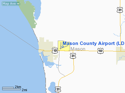
Mason County Airport (IATA: LDM, ICAO: KLDM, FAA LID: LDM) is a county-owned public-use airport located two miles (3 km) northeast of the central business district of Ludington, a city in Mason County, Michigan, United States.
Facilities and aircraft
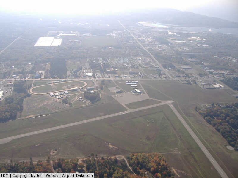
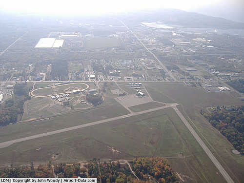
Mason County Airport covers an area of 238 acres (96 ha) which contains two asphalt paved runways: 8/26 measuring 5,003 x 75 ft (1,525 x 23 m) and 1/19 measuring 3,503 x 75 ft (1,068 x 23 m). For the 12-month period ending December 31, 2005, the airport had 15,188 aircraft operations, an average of 41 per day: 87% general aviation and 13% air taxi.
The above content comes from Wikipedia and is published under free licenses – click here to read more.
|
 |
(Click on the photo to enlarge) |
Location & QuickFacts
| FAA Information Effective: | 2008-09-25 |
| Airport Identifier: | LDM |
| Airport Status: | Operational |
| Longitude/Latitude: | 086-24-28.5000W/43-57-45.1000N
-86.407917/43.962528 (Estimated) |
| Elevation: | 646 ft / 196.90 m (Surveyed) |
| Land: | 238 acres |
| From nearest city: | 2 nautical miles NE of Ludington, MI |
| Location: | Mason County, MI |
| Magnetic Variation: | 03W (1985) |
Owner & Manager
| Ownership: | Publicly owned |
| Owner: | County Of Mason |
| Address: | Court House
Ludington, MI 49431 |
| Phone number: | 231-843-8202 |
| Manager: | Walter D. Johnson |
| Address: | 5300 West U.s. 10
Ludington, MI 49431 |
| Phone number: | 231-843-2049 |
Airport Operations and Facilities
| Airport Use: | Open to public |
| Wind indicator: | Yes |
| Segmented Circle: | Yes |
| Control Tower: | No |
| Lighting Schedule: | DUSK-DAWN
ACTVT MIRL RYS 08/26 & 01/19 PAPIS RYS 08, 26, 01 & 19, AND REIL RY 26 - CTAF. |
| Beacon Color: | Clear-Green (lighted land airport) |
| Landing fee charge: | No |
| Sectional chart: | Chicago |
| Region: | AGL - Great Lakes |
| Boundary ARTCC: | ZMP - Minneapolis |
| Tie-in FSS: | LAN - Lansing |
| FSS on Airport: | No |
| FSS Toll Free: | 1-800-WX-BRIEF |
| NOTAMs Facility: | LDM (NOTAM-d service avaliable) |
| Federal Agreements: | NGY |
Airport Communications
| CTAF: | 123.000 |
| Unicom: | 123.000 |
Airport Services
| Fuel available: | 100LLA |
| Airframe Repair: | MAJOR |
| Power Plant Repair: | MAJOR |
Runway Information
Runway 01/19
| Dimension: | 3503 x 75 ft / 1067.7 x 22.9 m |
| Surface: | ASPH, Good Condition |
| Weight Limit: | Single wheel: 19000 lbs. |
| Edge Lights: | Medium |
| |
Runway 01 |
Runway 19 |
| Longitude: | 086-24-46.9036W | 086-24-45.5173W |
| Latitude: | 43-57-33.0401N | 43-58-07.6204N |
| Elevation: | 641.00 ft | 637.00 ft |
| Alignment: | 2 | 127 |
| Traffic Pattern: | Left | Left |
| Markings: | Basic, Good Condition | Basic, Good Condition |
| VASI: | 2-light PAPI on left side | 2-light PAPI on left side |
| Runway End Identifier: | No | No |
| Centerline Lights: | No | No |
| Touchdown Lights: | No | No |
| Obstruction: | 24 ft ant, 1400.0 ft from runway, 187 ft right of centerline, 50:1 slope to clear | 55 ft trees, 1300.0 ft from runway, 20:1 slope to clear |
|
Runway 08/26
| Dimension: | 5003 x 75 ft / 1524.9 x 22.9 m |
| Surface: | ASPH, Good Condition |
| Weight Limit: | Single wheel: 25000 lbs. |
| Edge Lights: | Medium |
| |
Runway 08 |
Runway 26 |
| Longitude: | 086-24-48.4369W | 086-23-43.7607W |
| Latitude: | 43-57-33.4104N | 43-57-49.4909N |
| Elevation: | 641.00 ft | 646.00 ft |
| Alignment: | 71 | 127 |
| Traffic Pattern: | Left | Left |
| Markings: | Non-precision instrument, Good Condition | Non-precision instrument, Good Condition |
| Crossing Height: | 28.00 ft | 43.00 ft |
| VASI: | 2-light PAPI on left side | 2-light PAPI on left side |
| Visual Glide Angle: | 3.00° | 3.00° |
| Runway End Identifier: | No | Yes |
| Centerline Lights: | No | No |
| Touchdown Lights: | No | No |
| Obstruction: | 75 ft trees, 1700.0 ft from runway, 111 ft left of centerline, 20:1 slope to clear | 45 ft trees, 1800.0 ft from runway, 34:1 slope to clear |
|
Radio Navigation Aids
| ID |
Type |
Name |
Ch |
Freq |
Var |
Dist |
| CAD | NDB | Cadillac | | 269.00 | 04W | 46.8 nm |
| MBL | VOR/DME | Manistee | 051X | 111.40 | 05W | 19.7 nm |
| HIC | VOR/DME | White Cloud | 123X | 117.60 | 01W | 38.0 nm |
Remarks
- BIRDS & DEER ON & INVOF ARPT.
Images and information placed above are from
http://www.airport-data.com/airport/LDM/
We thank them for the data!
| General Info
|
| Country |
United States
|
| State |
MICHIGAN
|
| FAA ID |
LDM
|
| Latitude |
43-57-45.118N
|
| Longitude |
086-24-28.495W
|
| Elevation |
645 feet
|
| Near City |
LUDINGTON
|
We don't guarantee the information is fresh and accurate. The data may
be wrong or outdated.
For more up-to-date information please refer to other sources.
|
|