 |
|
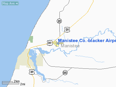
Manistee Co. - Blacker Airport |
| Manistee County-Blacker Airport |
| IATA: MBL – ICAO: KMBL |
| Summary |
| Airport type |
Public |
| Operator |
Manistee County Airport Authority |
| Location |
Manistee, Michigan |
| Elevation AMSL |
621 ft / 189.3 m |
| Coordinates |
44°16′21″N 86°14′49″W / 44.2725°N 86.24694°W / 44.2725; -86.24694Coordinates: 44°16′21″N 86°14′49″W / 44.2725°N 86.24694°W / 44.2725; -86.24694 |
| Runways |
| Direction |
Length |
Surface |
| ft |
m |
| 9/27 |
5,502 |
1,677 |
Asphalt |
| 18/36 |
2,720 |
829 |
Asphalt |
Manistee County-Blacker Airport (IATA: MBL, ICAO: KMBL) is a public airport located three miles (5 km) northeast of the central business district (CBD) of Manistee, a city in Manistee County, Michigan, USA. The airport covers 290 acres (117 ha) and has two runways. It is mostly used for general aviation. Great Lakes Airlines provides 2 round trips daily to MKE (Milwaukee).
On Saturday, April 1, 1961, the Manistee News-Advocate reported "North Central's inaugural Flight 914", piloted by Capt. Leslie C. Raatz. The aircraft was a Convair-340. Though the article does not explicitly say so, this was the first commercial flight to Manistee.
Airlines and destinations
| Airlines |
Destinations |
| Great Lakes Airlines |
Milwaukee |
The above content comes from Wikipedia and is published under free licenses – click here to read more.
Location & QuickFacts
| FAA Information Effective: | 2008-09-25 |
| Airport Identifier: | MBL |
| Airport Status: | Operational |
| Longitude/Latitude: | 086-14-48.8000W/44-16-20.9000N
-86.246889/44.272472 (Estimated) |
| Elevation: | 621 ft / 189.28 m (Surveyed) |
| Land: | 290 acres |
| From nearest city: | 3 nautical miles NE of Manistee, MI |
| Location: | Manistee County, MI |
| Magnetic Variation: | 01W (1965) |
Owner & Manager
| Ownership: | Publicly owned |
| Owner: | Manistee County |
| Address: | 2323 Airport Road
Manistee, MI 49660 |
| Phone number: | 231-723-4351 |
| Manager: | William J. House |
| Address: | 2323 Airport Rd
Manistee, MI 49660 |
| Phone number: | 231-723-4351 |
Airport Operations and Facilities
| Airport Use: | Open to public |
| Wind indicator: | Yes |
| Segmented Circle: | Yes |
| Control Tower: | No |
| Lighting Schedule: | DUSK-DAWN
ACTVT HIRL RY 09/27 & MIRL RY 18/36, REIL RY 09, PAPI RYS 09, 18, & 27 & 36 - CTAF. |
| Beacon Color: | Clear-Green (lighted land airport) |
| Landing fee charge: | No |
| Sectional chart: | Green Bay |
| Region: | AGL - Great Lakes |
| Boundary ARTCC: | ZMP - Minneapolis |
| Tie-in FSS: | LAN - Lansing |
| FSS on Airport: | No |
| FSS Toll Free: | 1-800-WX-BRIEF |
| NOTAMs Facility: | MBL (NOTAM-d service avaliable) |
| Certification type/date: | III A S 09/20
ARFF UNAVBL EXC ACR/OTHERS 24 HR PPR 231-723-4351. |
| Federal Agreements: | NGY |
Airport Communications
| CTAF: | 122.800 |
| Unicom: | 122.800 |
Airport Services
| Fuel available: | 100LLA |
| Airframe Repair: | MAJOR |
| Power Plant Repair: | MAJOR |
Runway Information
Runway 09/27
| Dimension: | 5500 x 100 ft / 1676.4 x 30.5 m |
| Surface: | ASPH, Good Condition |
| Weight Limit: | Single wheel: 26000 lbs.
Dual wheel: 31000 lbs. |
| Edge Lights: | High |
| |
Runway 09 |
Runway 27 |
| Longitude: | 086-15-17.3973W | 086-14-01.8241W |
| Latitude: | 44-16-22.1565N | 44-16-20.8016N |
| Elevation: | 618.00 ft | 621.00 ft |
| Alignment: | 91 | 127 |
| ILS Type: | | ILS
|
| Traffic Pattern: | Left | Left |
| Markings: | Precision instrument, Fair Condition
RY 9/27 MKG FADED. | Precision instrument, Fair Condition |
| Crossing Height: | 30.00 ft | 45.00 ft |
| VASI: | 4-light PAPI on left side | 4-light PAPI on left side |
| Visual Glide Angle: | 3.00° | 3.00° |
| Approach lights: | | MALSR |
| Runway End Identifier: | Yes | No |
| Centerline Lights: | No | No |
| Touchdown Lights: | No | No |
| Obstruction: | 55 ft tree, 2050.0 ft from runway, 100 ft left of centerline, 33:1 slope to clear | 102 ft trees, 4350.0 ft from runway, 950 ft left of centerline, 40:1 slope to clear |
|
Runway 18/36
| Dimension: | 2721 x 75 ft / 829.4 x 22.9 m |
| Surface: | ASPH, Good Condition |
| Weight Limit: | Single wheel: 12500 lbs. |
| Edge Lights: | Medium |
| |
Runway 18 |
Runway 36 |
| Longitude: | 086-15-07.0391W | 086-15-07.9699W |
| Latitude: | 44-16-33.0758N | 44-16-06.2166N |
| Elevation: | 618.00 ft | 618.00 ft |
| Alignment: | 127 | 1 |
| Traffic Pattern: | Left | Left |
| Markings: | Basic, Fair Condition
RY 18/36 MKG FADED.. | Basic, Fair Condition |
| Crossing Height: | 30.00 ft | 26.00 ft |
| VASI: | 2-light PAPI on left side | 2-light PAPI on left side |
| Visual Glide Angle: | 4.00° | 4.00° |
| Runway End Identifier: | No | No |
| Touchdown Lights: | No | No |
| Obstruction: | 49 ft trees, 1080.0 ft from runway, 172 ft left of centerline, 17:1 slope to clear | 8 ft tree, 312.0 ft from runway, 75 ft left of centerline, 14:1 slope to clear |
|
Radio Navigation Aids
| ID |
Type |
Name |
Ch |
Freq |
Var |
Dist |
| LDM | NDB | Ludington | | 341.00 | 03W | 19.9 nm |
| CAD | NDB | Cadillac | | 269.00 | 04W | 35.8 nm |
| TV | NDB | Gwenn | | 365.00 | 05W | 44.7 nm |
| MBL | VOR/DME | Manistee | 051X | 111.40 | 05W | 0.3 nm |
| HIC | VOR/DME | White Cloud | 123X | 117.60 | 01W | 47.8 nm |
| TVC | VORTAC | Traverse City | 093X | 114.60 | 02W | 38.2 nm |
Remarks
- DEER & BIRDS ON & INVOF ARPT.
- TWYS MKD WITH REFLECTORS.
- PART 139 CERTIFIED FOR SCHEDULED AIR CARRIERS 10-30 SEATS ONLY. UNSCHEDULED AIR CARRIERS OVER 30 SEATS NOT AUTHORIZED.
- ARFF MONITORING CTAF DURG ACR OPN.
- MAINT PSNL MONITORING CTAF DURG WORK ON TWYS AND RYS.
Images and information placed above are from
http://www.airport-data.com/airport/MBL/
We thank them for the data!
| General Info
|
| Country |
United States
|
| State |
MICHIGAN
|
| FAA ID |
MBL
|
| Latitude |
44-16-20.710N
|
| Longitude |
086-14-48.912W
|
| Elevation |
621 feet
|
| Near City |
MANISTEE
|
We don't guarantee the information is fresh and accurate. The data may
be wrong or outdated.
For more up-to-date information please refer to other sources.
|
|


