 |
|
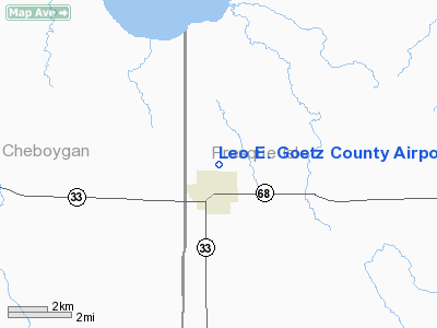
Leo E. Goetz County Airport |
Location & QuickFacts
| FAA Information Effective: | 2008-09-25 |
| Airport Identifier: | Y96 |
| Airport Status: | Operational |
| Longitude/Latitude: | 084-13-30.0520W/45-22-15.0430N
-84.225014/45.370845 (Estimated) |
| Elevation: | 830 ft / 252.98 m (Estimated) |
| Land: | 109 acres |
| From nearest city: | 1 nautical miles N of Onaway, MI |
| Location: | Presque Isle County, MI |
| Magnetic Variation: | 06W (1985) |
Owner & Manager
| Ownership: | Publicly owned |
| Owner: | Presque Isle County |
| Address: | 657 S. Bradley Hwy
Rogers City, MI 49779 |
| Phone number: | 989-734-4309 |
| Manager: | Michael T Jermeay
ASST MGR: RONALD DUGAN 989-734-2596. |
| Address: | 657 S. Bradley Hwy
Rogers City, MI 49779 |
| Phone number: | 989-734-4309 |
Airport Operations and Facilities
| Airport Use: | Open to public |
| Wind indicator: | Yes |
| Segmented Circle: | Yes |
| Control Tower: | No |
| Lighting Schedule: | DUSK-DAWN |
| Beacon Color: | Clear-Green (lighted land airport) |
| Landing fee charge: | No |
| Sectional chart: | Lake Huron |
| Region: | AGL - Great Lakes |
| Boundary ARTCC: | ZMP - Minneapolis |
| Tie-in FSS: | LAN - Lansing |
| FSS on Airport: | No |
| FSS Toll Free: | 1-800-WX-BRIEF |
| NOTAMs Facility: | LAN (NOTAM-d service avaliable) |
Airport Communications
Airport Services
| Airframe Repair: | NONE |
| Power Plant Repair: | NONE |
| Bottled Oxygen: | NONE |
| Bulk Oxygen: | NONE |
Runway Information
Runway 03/21
| Dimension: | 1400 x 100 ft / 426.7 x 30.5 m |
| Surface: | TURF, Fair Condition |
| |
Runway 03 |
Runway 21 |
| Traffic Pattern: | Left | Left |
| Obstruction: | 34 ft trees, 340.0 ft from runway, 125 ft right of centerline, 10:1 slope to clear | 34 ft trees, 102.0 ft from runway, 100 ft right of centerline, 3:1 slope to clear |
|
Runway 15/33
| Dimension: | 2600 x 60 ft / 792.5 x 18.3 m |
| Surface: | ASPH, Fair Condition |
| Edge Lights: | Medium |
| |
Runway 15 |
Runway 33 |
| Longitude: | 084-13-34.0000W | 084-13-15.7900W |
| Latitude: | 45-22-08.0000N | 45-21-45.7700N |
| Elevation: | 830.00 ft | 830.00 ft |
| Traffic Pattern: | Left | Left |
| Markings: | Basic, Good Condition | Basic, Good Condition |
| Obstruction: | 16 ft road, 525.0 ft from runway, 177 ft right of centerline, 20:1 slope to clear | 35 ft trees, 201.0 ft from runway, 75 ft left of centerline
RY 33, ALSO + 30 FT TREES, 800 FT DSTC, 125 FT R, APCH RATIO 20:1 BASED ON STRAIGHT OUT.
+25 FT TREES, 0-400 FT DSTC, 110 FT L. |
|
Radio Navigation Aids
| ID |
Type |
Name |
Ch |
Freq |
Var |
Dist |
| PZQ | NDB | Rogers City | | 215.00 | 07W | 17.2 nm |
| BFA | NDB | Boyne Falls | | 263.00 | 06W | 31.9 nm |
| DRM | NDB | Drummond Island | | 218.00 | 07W | 43.3 nm |
| CVX | NDB | Charlevoix | | 392.00 | 05W | 44.3 nm |
| GYG | NDB | Grayling | | 359.00 | 06W | 45.3 nm |
| CGG | VOR | Grayling | | 109.80 | 06W | 46.6 nm |
| GLR | VOR/DME | Gaylord | 029X | 109.20 | 06W | 29.6 nm |
| PLN | VORTAC | Pellston | 055X | 111.80 | 06W | 24.2 nm |
| APN | VORTAC | Alpena | 025X | 108.80 | 07W | 33.2 nm |
Remarks
- CONFIRM SNOW REMOVAL & WINTER CONDITIONS PHONE 989-734-2216 OR AMGR RES 989-734-4309.
- RANDOM +5-10 FT BRUSH & TREES IN PRIM SFC.
- RY 15, 11 FT POWERLINE 750 FT FM THLD 125 FT R OF CNTRLN. RY 33 14 FT POWERLINE, 676 FT FM THLD, APCH RATIO 34:1.
Images and information placed above are from
http://www.airport-data.com/airport/Y96/
We thank them for the data!
| General Info
|
| Country |
United States
|
| State |
MICHIGAN
|
| FAA ID |
Y96
|
| Latitude |
45-22-15.043N
|
| Longitude |
084-13-30.052W
|
| Elevation |
830 feet
|
| Near City |
ONAWAY
|
We don't guarantee the information is fresh and accurate. The data may
be wrong or outdated.
For more up-to-date information please refer to other sources.
|
|


