 |
|
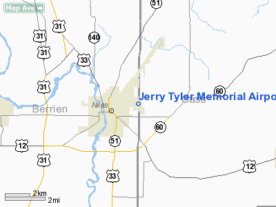
Jerry Tyler Memorial Airport |
|
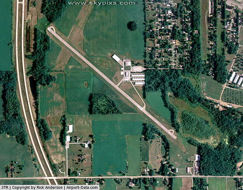 |
(Click on the photo to enlarge) |
Location & QuickFacts
| FAA Information Effective: | 2008-09-25 |
| Airport Identifier: | 3TR |
| Airport Status: | Operational |
| Longitude/Latitude: | 086-13-30.6340W/41-50-09.2690N
-86.225176/41.835908 (Estimated) |
| Elevation: | 750 ft / 228.60 m (Surveyed) |
| Land: | 169 acres |
| From nearest city: | 2 nautical miles NE of Niles, MI |
| Location: | Berrien County, MI |
| Magnetic Variation: | 01W (1980) |
Owner & Manager
| Ownership: | Publicly owned |
| Owner: | City Of Niles |
| Address: | 508 E. Main St
Niles, MI 49120 |
| Phone number: | 269-684-7031 |
| Manager: | Neil C. Coulston |
| Address: | P.o. Box 487, 508 East Main Street
Niles, MI 49120 |
| Phone number: | 269-683-4700 |
Airport Operations and Facilities
| Airport Use: | Open to public |
| Wind indicator: | Yes |
| Segmented Circle: | Yes |
| Control Tower: | No |
| Lighting Schedule: | DUSK-DAWN
ACTVT MIRL RY 14/32, REILS 14 & 32 - CTAF. |
| Beacon Color: | Clear-Green (lighted land airport) |
| Landing fee charge: | No |
| Sectional chart: | Chicago |
| Region: | AGL - Great Lakes |
| Traffic Pattern Alt: | 1500 ft |
| Boundary ARTCC: | ZAU - Chicago |
| Tie-in FSS: | LAN - Lansing |
| FSS on Airport: | No |
| FSS Toll Free: | 1-800-WX-BRIEF |
| NOTAMs Facility: | LAN (NOTAM-d service avaliable) |
| Federal Agreements: | N1 |
Airport Communications
| CTAF: | 122.800 |
| Unicom: | 122.800 |
Airport Services
| Fuel available: | 100LLA |
| Airframe Repair: | MAJOR |
| Power Plant Repair: | MAJOR |
| Bottled Oxygen: | NONE |
| Bulk Oxygen: | NONE |
Runway Information
Runway 03/21
| Dimension: | 3315 x 50 ft / 1010.4 x 15.2 m |
| Surface: | ASPH, Poor Condition
RY 03/21 PAVEMENT CRACKED & BROKEN. |
| Weight Limit: | Single wheel: 8000 lbs. |
| |
Runway 03 |
Runway 21 |
| Longitude: | 086-13-44.0020W | 086-13-19.5800W |
| Latitude: | 41-49-57.3580N | 41-50-24.5510N |
| Elevation: | 737.00 ft | 743.00 ft |
| Alignment: | 34 | 127 |
| Traffic Pattern: | Left | Left |
| Markings: | Non-precision instrument, Poor Condition
RY 03/21 MARKINGS FADED. | Non-precision instrument, Poor Condition |
| Displaced threshold: | 900.00 ft | 750.00 ft |
| Runway End Identifier: | No | No |
| Touchdown Lights: | No | No |
| Obstruction: | 15 ft road, 201.0 ft from runway, 203 ft left of centerline
APCH RATIO 20:1 TO DSPLCD THLD BASED ON +58 FT TREES, 1160 FT FM DSPLCD THLD,78R.
+6FT FENCE, 144 FT DSTC, 115 FT L | 60 ft trees, 500.0 ft from runway, 250 ft left of centerline, 5:1 slope to clear
APCH RATIO 20:1 TO DSPLCD THLD OVR + 70 FT TREES, 1400 FT DSTC. |
|
Runway 14/32
| Dimension: | 4100 x 75 ft / 1249.7 x 22.9 m |
| Surface: | ASPH, Good Condition
RY 03/21 PAVEMENT CRACKED & BROKEN. |
| Weight Limit: | Single wheel: 25000 lbs. |
| Edge Lights: | Medium |
| |
Runway 14 |
Runway 32 |
| Longitude: | 086-13-44.8850W | 086-13-14.5600W |
| Latitude: | 41-50-24.5920N | 41-49-51.0460N |
| Elevation: | 742.00 ft | 750.00 ft |
| Alignment: | 127 | 127 |
| Traffic Pattern: | Left | Left |
| Markings: | Non-precision instrument, Good Condition | Non-precision instrument, Good Condition |
| Displaced threshold: | 300.00 ft | 0.00 ft |
| Runway End Identifier: | Yes | Yes |
| Touchdown Lights: | No | No |
| Obstruction: | 15 ft road, 390.0 ft from runway, 12:1 slope to clear
APCH RATIO 14:1 TO DSPLCD THLD OVR 51 FT POLE, 78L, 738 FT FM DSPLCD THLD; 25:1 BASED ON STRAIGHT OUT OVER +72 FT TREES, 1800 FT DSTC. | 70 ft trees, 1600.0 ft from runway, 20:1 slope to clear |
|
Radio Navigation Aids
| ID |
Type |
Name |
Ch |
Freq |
Var |
Dist |
| MGC | NDB | Michigan City | | 203.00 | 01W | 27.6 nm |
| HAI | NDB | Three Rivers | | 407.00 | 02W | 29.3 nm |
| IUL | NDB | La Porte | | 356.00 | 03W | 31.8 nm |
| IRS | NDB | Sturgis | | 382.00 | 04W | 35.5 nm |
| VP | NDB | Sedly | | 212.00 | 02W | 37.3 nm |
| CPB | NDB | Culver | | 391.00 | 01W | 37.9 nm |
| RCR | NDB | Rochester | | 216.00 | 03W | 46.4 nm |
| RWN | NDB | Winamac/dcmsnd | | 335.00 | 00W | 47.8 nm |
| OLK | VOR | Wolf Lake | | 110.40 | 03W | 48.2 nm |
| ELX | VOR/DME | Keeler | 113X | 116.60 | 00E | 19.1 nm |
| OXI | VOR/DME | Knox | 103X | 115.60 | 00E | 36.3 nm |
| PMM | VOR/DME | Pullman | 058X | 112.10 | 00E | 38.3 nm |
| AZO | VOR/DME | Kalamazoo | 027X | 109.00 | 01W | 38.5 nm |
| GIJ | VORTAC | Gipper | 101X | 115.40 | 00E | 5.8 nm |
| GSH | VORTAC | Goshen | 084X | 113.70 | 00E | 20.7 nm |
Remarks
- OBSTN LGTD POLES, IN RWY 14-TRANSITION ZONE.
- TREES BETWEEN RY 03 & RY 32 AND BETWEEN RY 32 & RY 21 OBSTRUCT VIEW OF RY ENDS.
- GCO AVBL ON FREQ 121.725 THRU SBN CD & FLT SVCS.
Images and information placed above are from
http://www.airport-data.com/airport/3TR/
We thank them for the data!
| General Info
|
| Country |
United States
|
| State |
MICHIGAN
|
| FAA ID |
3TR
|
| Latitude |
41-50-09.269N
|
| Longitude |
086-13-30.634W
|
| Elevation |
750 feet
|
| Near City |
NILES
|
We don't guarantee the information is fresh and accurate. The data may
be wrong or outdated.
For more up-to-date information please refer to other sources.
|
|


