|
|
|
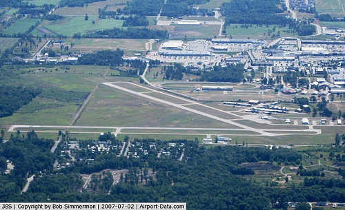 |
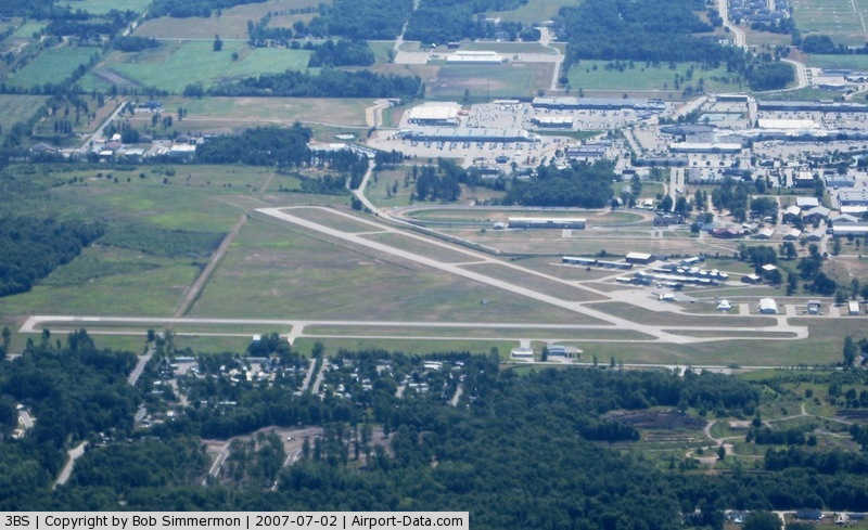
(Click on the photo to enlarge) |
Location & QuickFacts
| FAA Information Effective: | 2008-09-25 |
| Airport Identifier: | 3BS |
| Airport Status: | Operational |
| Longitude/Latitude: | 084-15-40.7000W/43-39-46.5000N
-84.261306/43.662917 (Estimated) |
| Elevation: | 635 ft / 193.55 m (Surveyed) |
| Land: | 512 acres |
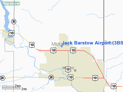
| From nearest city: | 3 nautical miles NW of Midland, MI |
| Location: | Midland County, MI |
| Magnetic Variation: | 06W (2000) |
Owner & Manager
| Ownership: | Publicly owned |
| Owner: | City Of Midland |
| Address: | 333 W. Ellsworth
Midland, MI 48640 |
| Phone number: | 989-837-3300
ARPT PHONE 989-835-3231. |
| Manager: | Brian Mcmanus |
| Address: | 333 W. Ellsworth
Midland, MI 48640 |
| Phone number: | 989-835-3231 |
Airport Operations and Facilities
| Airport Use: | Open to public |
| Wind indicator: | Yes |
| Segmented Circle: | Yes |
| Control Tower: | No |
| Lighting Schedule: | DUSK-DAWN
MIRL RYS 06/24 & 18/36 PRESET ON LOW INTST DUSK-2300. AFTER 2300 ACTVT - CTAF. TO INCR INTST & ACTVT VASI & REIL RYS 06; 24; 18 & 36 - CTAF. |
| Beacon Color: | Clear-Green (lighted land airport) |
| Landing fee charge: | No |
| Sectional chart: | Detroit |
| Region: | AGL - Great Lakes |
| Boundary ARTCC: | ZOB - Cleveland |
| Tie-in FSS: | LAN - Lansing |
| FSS on Airport: | No |
| FSS Toll Free: | 1-800-WX-BRIEF |
| NOTAMs Facility: | LAN (NOTAM-d service avaliable) |
| Federal Agreements: | NGY |
Airport Communications
| CTAF: | 122.800 |
| Unicom: | 122.800 |
Airport Services
| Fuel available: | 100LLA |
| Airframe Repair: | MAJOR |
| Power Plant Repair: | MAJOR |
| Bottled Oxygen: | NONE |
| Bulk Oxygen: | NONE |
Runway Information
Runway 06/24
| Dimension: | 3801 x 75 ft / 1158.5 x 22.9 m |
| Surface: | ASPH, Good Condition |
| Weight Limit: | Single wheel: 24000 lbs. |
| Edge Lights: | Medium |
| |
Runway 06 |
Runway 24 |
| Longitude: | 084-15-55.2097W | 084-15-10.4146W |
| Latitude: | 43-39-36.7682N | 43-39-55.5154N |
| Elevation: | 621.00 ft | 634.00 ft |
| Alignment: | 60 | 127 |
| Traffic Pattern: | Left | Left |
| Markings: | Non-precision instrument, Good Condition | Non-precision instrument, Good Condition |
| VASI: | 2-light PAPI on left side | 2-light PAPI on left side |
| Runway End Identifier: | Yes | Yes |
| Centerline Lights: | No | No |
| Touchdown Lights: | No | No |
| Obstruction: | 41 ft trees, 611.0 ft from runway, 250 ft left of centerline, 10:1 slope to clear | 82 ft trees, 1840.0 ft from runway, 368 ft right of centerline, 20:1 slope to clear |
|
Runway 18/36
| Dimension: | 3001 x 75 ft / 914.7 x 22.9 m |
| Surface: | ASPH, Good Condition |
| Weight Limit: | Single wheel: 24000 lbs. |
| Edge Lights: | Medium |
| |
Runway 18 |
Runway 36 |
| Longitude: | 084-15-50.7325W | 084-15-50.7753W |
| Latitude: | 43-40-01.8535N | 43-39-32.2147N |
| Elevation: | 628.00 ft | 620.00 ft |
| Alignment: | 127 | 0 |
| Traffic Pattern: | Left | Left |
| Markings: | Non-precision instrument, Fair Condition
PAINT FADED, NORTH END | Non-precision instrument, Fair Condition |
| VASI: | 2-light PAPI on left side | 2-light PAPI on left side |
| Runway End Identifier: | Yes | Yes |
| Centerline Lights: | No | No |
| Touchdown Lights: | No | No |
| Obstruction: | 79 ft trees, 2175.0 ft from runway, 25:1 slope to clear | 50 ft trees, 1250.0 ft from runway, 21:1 slope to clear |
|
Radio Navigation Aids
| ID |
Type |
Name |
Ch |
Freq |
Var |
Dist |
| GDW | NDB | Wiggins | | 209.00 | 04W | 20.7 nm |
| HYX | NDB | Browne | | 385.00 | 06W | 22.4 nm |
| AMN | NDB | Alma | | 329.00 | 05W | 30.6 nm |
| BHW | NDB | Hardwood | | 236.00 | 06W | 36.0 nm |
| MBS | VOR/DME | Saginaw | 076X | 112.90 | 03W | 11.2 nm |
| MOP | VOR/DME | Mount Pleasant | 043X | 110.60 | 05W | 20.8 nm |
| BXZ | VOR/DME | West Branch | 079X | 113.20 | 06W | 35.0 nm |
| HTL | VOR/DME | Houghton Lake | 053X | 111.60 | 05W | 45.3 nm |
| FNT | VORTAC | Flint | 116X | 116.90 | 06W | 47.5 nm |
Remarks
- DEER ON & INVOF ARPT.
- GCO AVBL ON FREQ 121.725 THRU SAGINAW CD & FLT SVCS.
- GCO OTS INDEFLY.
- OCNL ULTRALIGHT ACTIVITY.
- NOISE SENSITIVE AREA SOUTH OF ARPT; USE PREFERRED RY 06/24.
Images and information placed above are from
http://www.airport-data.com/airport/3BS/
We thank them for the data!
| General Info
|
| Country |
United States
|
| State |
MICHIGAN
|
| FAA ID |
3BS
|
| Latitude |
43-39-46.495N
|
| Longitude |
084-15-40.770W
|
| Elevation |
636 feet
|
| Near City |
MIDLAND
|
We don't guarantee the information is fresh and accurate. The data may
be wrong or outdated.
For more up-to-date information please refer to other sources.
|
|