 |
|
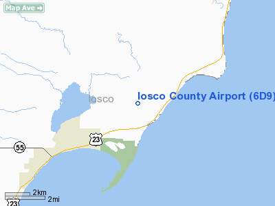
Location & QuickFacts
| FAA Information Effective: | 2008-09-25 |
| Airport Identifier: | 6D9 |
| Airport Status: | Operational |
| Longitude/Latitude: | 083-25-20.2950W/44-18-46.1590N
-83.422304/44.312822 (Estimated) |
| Elevation: | 606 ft / 184.71 m (Surveyed) |
| Land: | 276 acres |
| From nearest city: | 3 nautical miles NE of East Tawas, MI |
| Location: | Iosco County, MI |
| Magnetic Variation: | 03W (1965) |
Owner & Manager
| Ownership: | Publicly owned |
| Owner: | Iosco County |
| Address: | 422 Lake St
Tawas City, MI 48763 |
| Phone number: | 989-362-4214 |
| Manager: | Marvin W. Poland |
| Address: | 1131 Aulerich Rd
East Tawas, MI 48730 |
| Phone number: | 989-362-0052
AMGR HOME PHONE AFTER 1700 LCL 989-362-4515. |
Airport Operations and Facilities
| Airport Use: | Open to public |
| Wind indicator: | Yes |
| Segmented Circle: | Yes |
| Control Tower: | No |
| Lighting Schedule: | DUSK-DAWN
ACTVT MIRL RY 08/26 - 122.85. |
| Beacon Color: | Clear-Green (lighted land airport) |
| Landing fee charge: | No |
| Sectional chart: | Lake Huron |
| Region: | AGL - Great Lakes |
| Boundary ARTCC: | ZMP - Minneapolis |
| Tie-in FSS: | LAN - Lansing |
| FSS on Airport: | No |
| FSS Toll Free: | 1-800-WX-BRIEF |
| NOTAMs Facility: | LAN (NOTAM-d service avaliable) |
| Federal Agreements: | GSY |
Airport Communications
| CTAF: | 122.800 |
| Unicom: | 122.800 |
Airport Services
| Fuel available: | 100LL |
| Airframe Repair: | MAJOR
FOR RPRS CALL 989-362-5832. |
| Power Plant Repair: | MAJOR |
| Bottled Oxygen: | NONE |
| Bulk Oxygen: | NONE |
Runway Information
Runway 08/26
| Dimension: | 4802 x 75 ft / 1463.6 x 22.9 m |
| Surface: | ASPH, Good Condition |
| Weight Limit: | Single wheel: 12000 lbs. |
| Edge Lights: | Medium |
| |
Runway 08 |
Runway 26 |
| Longitude: | 083-25-52.5900W | 083-24-47.9740W |
| Latitude: | 44-18-41.3080N | 44-18-51.1010N |
| Elevation: | 605.00 ft | 604.00 ft |
| Alignment: | 78 | 127 |
| Traffic Pattern: | Left | Left |
| Markings: | Non-precision instrument, Good Condition | Non-precision instrument, Good Condition |
| Crossing Height: | 33.00 ft | 33.00 ft |
| VASI: | 2-light PAPI on left side | 2-light PAPI on left side |
| Visual Glide Angle: | 3.00° | 3.00° |
| Runway End Identifier: | Yes | Yes |
| Centerline Lights: | No | No |
| Touchdown Lights: | No | No |
| Obstruction: | 48 ft tree, 1160.0 ft from runway, 159 ft right of centerline, 20:1 slope to clear | 45 ft trees, 1325.0 ft from runway, 10 ft left of centerline, 25:1 slope to clear |
|
Radio Navigation Aids
| ID |
Type |
Name |
Ch |
Freq |
Var |
Dist |
| BHW | NDB | Hardwood | | 236.00 | 06W | 28.7 nm |
| GDW | NDB | Wiggins | | 209.00 | 04W | 49.9 nm |
| ASP | VOR/DME | Au Sable | 108X | 116.10 | 07W | 8.3 nm |
| BXZ | VOR/DME | West Branch | 079X | 113.20 | 06W | 33.0 nm |
| BAX | VOR/DME | Bad Axe | 019X | 108.20 | 05W | 37.0 nm |
| APN | VORTAC | Alpena | 025X | 108.80 | 07W | 46.6 nm |
Remarks
- NUMEROUS DEER ON & INVOF ARPT.
Images and information placed above are from
http://www.airport-data.com/airport/6D9/
We thank them for the data!
| General Info
|
| Country |
United States
|
| State |
MICHIGAN
|
| FAA ID |
6D9
|
| Latitude |
44-18-46.159N
|
| Longitude |
083-25-20.295W
|
| Elevation |
606 feet
|
| Near City |
EAST TAWAS
|
We don't guarantee the information is fresh and accurate. The data may
be wrong or outdated.
For more up-to-date information please refer to other sources.
|
|


