 |
|
|
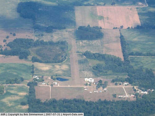 |
(Click on the photo to enlarge) |
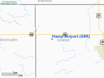
Location & QuickFacts
| FAA Information Effective: | 2008-09-25 |
| Airport Identifier: | 68R |
| Airport Status: | Operational |
| Longitude/Latitude: | 084-48-03.0410W/43-23-58.1130N
-84.800845/43.399476 (Estimated) |
| Elevation: | 825 ft / 251.46 m (Estimated) |
| Land: | 12 acres |
| From nearest city: | 3 nautical miles W of Elwell, MI |
| Location: | Gratiot County, MI |
| Magnetic Variation: | 04W (1985) |
Owner & Manager
| Ownership: | Privately owned |
| Owner: | Harold Hamp
OWNER LIVES ON PREMISES. |
| Address: | 7350 Osborn
Elwell, MI 48832 |
| Phone number: | 989-463-1762 |
| Manager: | Harold Hamp |
| Address: | 7350 Osborn
Elwell, MI 48832 |
| Phone number: | 989-463-1762 |
Airport Operations and Facilities
| Airport Use: | Open to public |
| Wind indicator: | Yes |
| Segmented Circle: | No |
| Control Tower: | No |
| Lighting Schedule: | NONE |
| Sectional chart: | Detroit |
| Region: | AGL - Great Lakes |
| Boundary ARTCC: | ZOB - Cleveland |
| Tie-in FSS: | LAN - Lansing |
| FSS on Airport: | No |
| FSS Toll Free: | 1-800-WX-BRIEF |
| NOTAMs Facility: | LAN (NOTAM-d service avaliable) |
Airport Communications
Airport Services
| Airframe Repair: | MAJOR |
| Power Plant Repair: | MAJOR |
Runway Information
Runway 09/27
| Dimension: | 2580 x 100 ft / 786.4 x 30.5 m |
| Surface: | TURF, Fair Condition
ROLLING TERRAIN. |
| Edge Lights: | Non-standard lighting system
NSTD RY LGTING- FOR LOCAL USE ONLY |
| |
Runway 09 |
Runway 27 |
| Traffic Pattern: | Left | Left |
| Displaced threshold: | 1180.00 ft | 0.00 ft |
| Obstruction: | 30 ft pole, 4.0 ft from runway, 90 ft right of centerline
RWY 09 APCH RATIO 20:1 TO DSPLCD THR OVER 95 FT TREES;1900 FT L/R; ALSO, APCH RATIO 3:1 OVER 15 FT ROAD, 50 FT DSTC, 0B. | 40 ft trees, 0.0 ft from runway, 100L/ ft right of centerline
20:1 STRAIGHT OUT. |
|
Radio Navigation Aids
| ID |
Type |
Name |
Ch |
Freq |
Var |
Dist |
| AMN | NDB | Alma | | 329.00 | 05W | 4.6 nm |
| GDW | NDB | Wiggins | | 209.00 | 04W | 37.1 nm |
| HYX | NDB | Browne | | 385.00 | 06W | 41.2 nm |
| MOP | VOR/DME | Mount Pleasant | 043X | 110.60 | 05W | 13.7 nm |
| MBS | VOR/DME | Saginaw | 076X | 112.90 | 03W | 32.5 nm |
| HIC | VOR/DME | White Cloud | 123X | 117.60 | 01W | 41.3 nm |
| GRR | VOR/DME | Grand Rapids | 106Y | 115.95 | 04W | 47.9 nm |
| LAN | VORTAC | Lansing | 045X | 110.80 | 05W | 41.2 nm |
Remarks
- TREES & BRUSH IN PRIM SFC; BOTH SIDES OF RY.
- OBSTN IN RY APCH SLOPE SFC BE REMOVED/LOWERED OR RY THR BE DSPLCD AND MKD & LGTD FOR NGT OPN TO PRVD MINIMUM 20:1 APCH SFC CLNC OVER OBSTNS; AREA 125 FT EITHER SIDE OF RY C/L AND EXTENDING TO A POINT 300 FT BYD RY ENDS CLEAR OF OBSTN.
Images and information placed above are from
http://www.airport-data.com/airport/68R/
We thank them for the data!
| General Info
|
| Country |
United States
|
| State |
MICHIGAN
|
| FAA ID |
68R
|
| Latitude |
43-23-58.113N
|
| Longitude |
084-48-03.041W
|
| Elevation |
825 feet
|
| Near City |
ELWELL
|
We don't guarantee the information is fresh and accurate. The data may
be wrong or outdated.
For more up-to-date information please refer to other sources.
|
|


