 |
|
| Gaylord Regional Airport |
| IATA: GLR – ICAO: KGLR |
| Summary |
| Airport type |
Public |
| Operator |
Otsego County |
| Location |
Gaylord, Michigan |
| Elevation AMSL |
1328 ft / 404.8 m |
| Coordinates |
45°00′48.745″N 84°42′13.028″W / 45.01354028°N 84.70361889°W / 45.01354028; -84.70361889Coordinates: 45°00′48.745″N 84°42′13.028″W / 45.01354028°N 84.70361889°W / 45.01354028; -84.70361889 |
| Runways |
| Direction |
Length |
Surface |
| ft |
m |
| 9/27 |
6,578 |
2,006 |
Asphalt |
| 18/36 |
3,000 |
915 |
Asphalt |
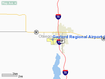
Gaylord Regional Airport (IATA: GLR, ICAO: KGLR) is a public airport located 1 mile (2 km) southwest of Gaylord in Otsego County, Michigan, USA. Facilities
The airport is staffed seven days a week from 7:00AM until 5:00PM. It is listed as a tier one airport in all categories of the Michigan Airport System Plan.
Runways
- Runway 9/27: 6,578 x 150 ft. (2,006 x 46 m), Surface: Asphalt
- Runway 18/36: 4,285 x 75 ft. (915 x 23 m), Surface: Asphalt
Transit
- The airport is accessible by road from Van Tyle Rd, and is close to M-32 and I-75.
The above content comes from Wikipedia and is published under free licenses – click here to read more.
Location & QuickFacts
| FAA Information Effective: | 2008-09-25 |
| Airport Identifier: | GLR |
| Airport Status: | Operational |
| Longitude/Latitude: | 084-42-12.9000W/45-00-49.1000N
-84.703583/45.013639 (Estimated) |
| Elevation: | 1328 ft / 404.77 m (Surveyed) |
| Land: | 1572 acres |
| From nearest city: | 1 nautical miles SW of Gaylord, MI |
| Location: | Otsego County, MI |
| Magnetic Variation: | 06W (2000) |
Owner & Manager
| Ownership: | Publicly owned |
| Owner: | County Of Otsego |
| Address: | 225 W. Main
Gaylord, MI 49735 |
| Phone number: | 989-732-4218 |
| Manager: | Scott Woody |
| Address: | 1100 Aero Dr.
Gaylord, MI 49734 |
| Phone number: | 989-732-4218
989-390-1170 MGR CELL. |
Airport Operations and Facilities
| Airport Use: | Open to public |
| Wind indicator: | Yes |
| Segmented Circle: | Yes |
| Control Tower: | No |
| Lighting Schedule: | DUSK-DAWN
ACTVT HIRL RY 09/27 & MIRL RY 18/36, REIL RY 27 & MALSR RY 09 - CTAF |
| Beacon Color: | Clear-Green (lighted land airport) |
| Landing fee charge: | No
LDG FEE FOR TURBINES, JETS & TWINS. LDG FEE WAIVED WITH MINIMUM FUEL PURCHASE. OVRNGT PARKING FEE.. |
| Sectional chart: | Lake Huron |
| Region: | AGL - Great Lakes |
| Boundary ARTCC: | ZMP - Minneapolis |
| Tie-in FSS: | LAN - Lansing |
| FSS on Airport: | No |
| FSS Toll Free: | 1-800-WX-BRIEF |
| NOTAMs Facility: | GLR (NOTAM-d service avaliable) |
| Federal Agreements: | NGY |
Airport Communications
| CTAF: | 122.800 |
| Unicom: | 122.800 |
Airport Services
| Fuel available: | 100LLA
AFTER HOURS CALL-IN FEE. |
| Airframe Repair: | MAJOR |
| Power Plant Repair: | MAJOR |
| Bottled Oxygen: | NONE |
| Bulk Oxygen: | NONE |
Runway Information
Runway 09/27
| Dimension: | 6578 x 150 ft / 2005.0 x 45.7 m |
| Surface: | ASPH, Good Condition
EXTENSIVE CRACKING IN PVMNT. |
| Weight Limit: | Dual wheel: 100000 lbs. |
| Edge Lights: | High |
| |
Runway 09 |
Runway 27 |
| Longitude: | 084-43-01.2502W | 084-41-29.6803W |
| Latitude: | 45-00-52.2216N | 45-00-52.0958N |
| Elevation: | 1321.00 ft | 1328.00 ft |
| Alignment: | 90 | 127 |
| ILS Type: | ILS
| |
| Traffic Pattern: | Left | Left |
| Markings: | Precision instrument, Good Condition | Precision instrument, Good Condition |
| Crossing Height: | 25.00 ft | 25.00 ft |
| VASI: | 4-light PAPI on left side | 4-light PAPI on left side |
| Visual Glide Angle: | 3.00° | 3.00° |
| Approach lights: | MALSR | |
| Runway End Identifier: | | Yes |
| Centerline Lights: | No | No |
| Touchdown Lights: | No | No |
| Obstruction: | 70 ft trees, 2600.0 ft from runway, 20 ft left of centerline, 34:1 slope to clear | 30 ft trees, 950.0 ft from runway, 250 ft left of centerline, 25:1 slope to clear |
|
Runway 18/36
| Dimension: | 3319 x 75 ft / 1011.6 x 22.9 m |
| Surface: | ASPH, Poor Condition
EXTENSIVE CRACKING IN PVMNT. |
| Weight Limit: | Single wheel: 12500 lbs. |
| Edge Lights: | Medium |
| |
Runway 18 |
Runway 36 |
| Longitude: | 084-42-07.6367W | 084-42-07.7331W |
| Latitude: | 45-00-59.4522N | 45-00-26.6751N |
| Elevation: | 1322.00 ft | 1316.00 ft |
| Alignment: | 127 | 0 |
| Traffic Pattern: | Left | Left |
| Markings: | Basic, Fair Condition
RWY 18/36 MKGS FADED. | Basic, Fair Condition |
| Crossing Height: | 41.00 ft | 41.00 ft |
| VASI: | 4-light PAPI on left side | 4-light PAPI on left side |
| Visual Glide Angle: | 4.00° | 4.00° |
| Runway End Identifier: | No | No |
| Centerline Lights: | | No |
| Touchdown Lights: | No | No |
| Obstruction: | 28 ft trees, 900.0 ft from runway, 125 ft left of centerline, 25:1 slope to clear | 12 ft trees, 608.0 ft from runway, 155 ft right of centerline, 34:1 slope to clear |
|
Radio Navigation Aids
| ID |
Type |
Name |
Ch |
Freq |
Var |
Dist |
| BFA | NDB | Boyne Falls | | 263.00 | 06W | 13.1 nm |
| GYG | NDB | Grayling | | 359.00 | 06W | 16.7 nm |
| CXK | NDB | Clam Lake | | 251.00 | 05W | 23.8 nm |
| CVX | NDB | Charlevoix | | 392.00 | 05W | 29.6 nm |
| TV | NDB | Gwenn | | 365.00 | 05W | 35.2 nm |
| PZQ | NDB | Rogers City | | 215.00 | 07W | 44.2 nm |
| CGG | VOR | Grayling | | 109.80 | 06W | 20.0 nm |
| HTL | VOR/DME | Houghton Lake | 053X | 111.60 | 05W | 39.4 nm |
| PLN | VORTAC | Pellston | 055X | 111.80 | 06W | 37.1 nm |
| TVC | VORTAC | Traverse City | 093X | 114.60 | 02W | 41.6 nm |
| APN | VORTAC | Alpena | 025X | 108.80 | 07W | 48.9 nm |
Remarks
- DEER & BIRDS ON & INVOF ARPT.
- MILITARY TRAINING ACTIVITY VCNTY OF ARPT ASSOC WITH RESTRICTED AREA R4201A/B.
Images and information placed above are from
http://www.airport-data.com/airport/GLR/
We thank them for the data!
| General Info
|
| Country |
United States
|
| State |
MICHIGAN
|
| FAA ID |
GLR
|
| Time |
UTC-5(-4DT)
|
| Latitude |
45.013542
45° 00' 48.75" N
|
| Longitude |
-84.703619
084° 42' 13.03" W
|
| Elevation |
1328 feet
405 meters
|
| Magnetic Variation |
006° W (01/06)
|
| Beacon |
Yes
|
| Operating Agency |
U.S.CIVIL AIRPORT WHEREIN PERMIT COVERS USE BY TRANSIT MILITARY AIRCRAFT
|
| Operating Hours |
SEE REMARKS FOR OPERATING HOURS OR COMMUNICATIONS FOR POSSIBLE HOURS
|
| Daylight Saving Time |
Second Sunday in March at 0200 to first Sunday in November at 0200 local time (Exception Arizona and that portion of Indiana in the Eastern Time Zone)
|
We don't guarantee the information is fresh and accurate. The data may
be wrong or outdated.
For more up-to-date information please refer to other sources.
|
|


