 |
|
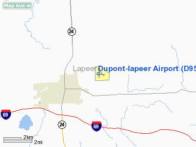
Location & QuickFacts
| FAA Information Effective: | 2008-09-25 |
| Airport Identifier: | D95 |
| Airport Status: | Operational |
| Longitude/Latitude: | 083-16-19.1378W/43-03-59.1301N
-83.271983/43.066425 (Estimated) |
| Elevation: | 834 ft / 254.20 m (Estimated) |
| Land: | 255 acres |
| From nearest city: | 2 nautical miles NE of Lapeer, MI |
| Location: | Lapeer County, MI |
| Magnetic Variation: | 07W (2000) |
Owner & Manager
| Ownership: | Publicly owned |
| Owner: | Mayfield Twp |
| Address: | 1900 N Saginaw Rd.
Lapeer, MI 48446 |
| Phone number: | 810-664-0821 |
| Manager: | Dave Hingst |
| Address: | 1232 Roods Lake Road
Lapeer, MI 48446 |
| Phone number: | 810-664-6966 |
Airport Operations and Facilities
| Airport Use: | Open to public |
| Wind indicator: | Yes |
| Segmented Circle: | Yes |
| Control Tower: | No |
| Lighting Schedule: | DUSK-2300
FOR ROTG BCN AFT 2300 ACTVT - CTAF. |
| Beacon Color: | Clear-Green (lighted land airport) |
| Landing fee charge: | No |
| Sectional chart: | Detroit |
| Region: | AGL - Great Lakes |
| Boundary ARTCC: | ZOB - Cleveland |
| Tie-in FSS: | LAN - Lansing |
| FSS on Airport: | No |
| FSS Toll Free: | 1-800-WX-BRIEF |
| NOTAMs Facility: | LAN (NOTAM-d service avaliable) |
| Federal Agreements: | NGY |
Airport Communications
| CTAF: | 123.000 |
| Unicom: | 123.000 |
Airport Services
| Fuel available: | 100LL |
| Airframe Repair: | MAJOR |
| Power Plant Repair: | MAJOR |
| Bottled Oxygen: | NONE |
| Bulk Oxygen: | NONE |
Runway Information
Runway 09/27
| Dimension: | 1900 x 150 ft / 579.1 x 45.7 m |
| Surface: | TURF, Fair Condition |
| |
Runway 09 |
Runway 27 |
| Longitude: | 083-16-25.1200W | 083-15-59.5400W |
| Latitude: | 43-03-54.8600N | 43-03-55.5200N |
| Elevation: | 829.00 ft | 827.00 ft |
| Alignment: | 88 | 127 |
| Traffic Pattern: | Left | Left |
| Displaced threshold: | 500.00 ft | 0.00 ft |
| Runway End Identifier: | No | No |
| Centerline Lights: | No | No |
| Touchdown Lights: | No | No |
| Obstruction: | 15 ft bldg, 216.0 ft from runway, 125 ft right of centerline, 14:1 slope to clear
RWY 09 APCH RATIO 20:1 TO DSPLCD THLD, +51' TREES 1236 FT DSTC. | 25 ft trees, 462.0 ft from runway, 50 ft left of centerline, 18:1 slope to clear |
|
Runway 18/36
| Dimension: | 3800 x 75 ft / 1158.2 x 22.9 m |
| Surface: | ASPH, Good Condition |
| Edge Lights: | Medium |
| |
Runway 18 |
Runway 36 |
| Longitude: | 083-16-21.2870W | 083-16-21.3970W |
| Latitude: | 43-04-19.9450N | 43-03-42.4110N |
| Elevation: | 834.00 ft | 829.00 ft |
| Alignment: | 127 | 127 |
| Traffic Pattern: | Left | Left |
| Markings: | Non-precision instrument, Fair Condition | Non-precision instrument, Fair Condition |
| Crossing Height: | 36.00 ft | 33.00 ft |
| VASI: | 4-light PAPI on left side | 2-light PAPI on left side |
| Visual Glide Angle: | 4.00° | 4.00° |
| Runway End Identifier: | Yes | Yes |
| Centerline Lights: | No | No |
| Touchdown Lights: | No | No |
| Obstruction: | 17 ft road, 624.0 ft from runway, 24:1 slope to clear | 25 ft pline, 752.0 ft from runway, 22:1 slope to clear |
|
Radio Navigation Aids
| ID |
Type |
Name |
Ch |
Freq |
Var |
Dist |
| HYX | NDB | Browne | | 385.00 | 06W | 33.8 nm |
| OZW | NDB | Howell | | 243.00 | 05W | 40.9 nm |
| VQ | NDB | Cargl | | 230.00 | 05W | 44.9 nm |
| ZR | NDB | Sarnia | | 404.00 | 06W | 46.3 nm |
| QG | NDB | Windsor | | 353.00 | 06W | 48.7 nm |
| MTC | TACAN | Selfridge | 064X | | 06W | 33.5 nm |
| BAX | VOR/DME | Bad Axe | 019X | 108.20 | 05W | 44.9 nm |
| MBS | VOR/DME | Saginaw | 076X | 112.90 | 03W | 45.0 nm |
| FNT | VORTAC | Flint | 116X | 116.90 | 06W | 21.7 nm |
| PSI | VORTAC | Pontiac | 047X | 111.00 | 03W | 24.8 nm |
| ECK | VORTAC | Peck | 087X | 114.00 | 07W | 26.8 nm |
| SVM | VORTAC | Salem | 090X | 114.30 | 03W | 42.0 nm |
| DET | VOT | Detroit City | | 111.60 | | 41.3 nm |
Remarks
- TWO CENTER & S TWY CONNECTORS CLSD INDEFLY.
- PROVIDED THRS ARE LCTD TO PROVIDE CLEAR 20:1 APCH AND APPROPRIATELY MKD AND LGTD.
Images and information placed above are from
http://www.airport-data.com/airport/D95/
We thank them for the data!
| General Info
|
| Country |
United States
|
| State |
MICHIGAN
|
| FAA ID |
D95
|
| Latitude |
43-03-59.795N
|
| Longitude |
083-16-20.408W
|
| Elevation |
844 feet
|
| Near City |
LAPEER
|
We don't guarantee the information is fresh and accurate. The data may
be wrong or outdated.
For more up-to-date information please refer to other sources.
|
|


