 |
|
| Day Field |
| IATA: none – ICAO: none – FAA LID: 6H4 |
| Summary |
| Airport type |
Public |
| Owner |
Sky High LLC |
| Serves |
Napoleon, Michigan |
| Elevation AMSL |
980 ft / 299 m |
| Coordinates |
42°09′23″N 084°20′04″W / 42.15639°N 84.33444°W / 42.15639; -84.33444 |
| Runways |
| Direction |
Length |
Surface |
| ft |
m |
| 9/27 |
2,105 |
642 |
Turf |
| Statistics (2005) |
| Aircraft operations |
204 |
| Based aircraft |
7 |
| Source: Federal Aviation Administration |
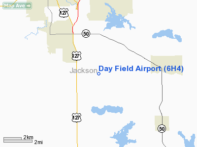
Day Field (FAA LID: 6H4) is a public use airport located in Jackson County, Michigan, United States. The airport is five nautical miles (9 km) west of the central business district of Napoleon, a community in Napoleon Township. It is privately owned by Sky High LLC.
Facilities and aircraft
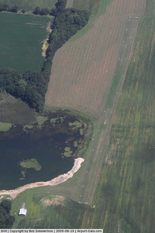
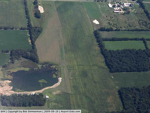
Day Field covers an area of 10 acres (4 ha) at an elevation of 980 feet (299 m) above mean sea level. It has one runway designated 9/27 with a turf surface measuring 2,105 by 55 feet (642 x 17 m).
For the 12-month period ending December 31, 2005, the airport had 204 general aviation aircraft operations, an average of 17 per month. At that time there were 7 aircraft based at this airport: 1 single-engine, 1 multi-engine, 1 helicopter and 4 ultralight.
The above content comes from Wikipedia and is published under free licenses – click here to read more.
|
 |
(Click on the photo to enlarge) |
|
 |
(Click on the photo to enlarge) |
Location & QuickFacts
| FAA Information Effective: | 2008-09-25 |
| Airport Identifier: | 6H4 |
| Airport Status: | Operational |
| Longitude/Latitude: | 084-20-03.8270W/42-09-23.1400N
-84.334396/42.156428 (Estimated) |
| Elevation: | 980 ft / 298.70 m (Estimated) |
| Land: | 10 acres |
| From nearest city: | 5 nautical miles W of Napoleon, MI |
| Location: | Jackson County, MI |
| Magnetic Variation: | 04W (1985) |
Owner & Manager
| Ownership: | Privately owned |
| Owner: | Janet Day |
| Address: | 4100 Hyde Rd.
Clark Lake, MI 49234 |
| Phone number: | 517-764-4193 |
| Manager: | Brian Van Wagnen
AMGR LIVES ON ARPT. |
| Address: | 4253 Saunt Rd
Jackson, MI 49201 |
| Phone number: | 517-764-4193 |
Airport Operations and Facilities
| Airport Use: | Open to public |
| Wind indicator: | Yes |
| Segmented Circle: | No |
| Control Tower: | No |
| Lighting Schedule: | PHONE REQ
FOR LIRL RY 09/27 CALL 517-764-4193. |
| Sectional chart: | Detroit |
| Region: | AGL - Great Lakes |
| Boundary ARTCC: | ZOB - Cleveland |
| Tie-in FSS: | LAN - Lansing |
| FSS Toll Free: | 1-800-WX-BRIEF |
| NOTAMs Facility: | LAN (NOTAM-d service avaliable) |
Airport Communications
Airport Services
Runway Information
Runway 09/27
| Dimension: | 2105 x 55 ft / 641.6 x 16.8 m |
| Surface: | TURF, Fair Condition |
| Edge Lights: | Non-standard lighting system
RWY 09/27 LIRL NSTD. THR LGTS ALL RED; LGTS UNEVENLY SPACED. NOT FOR PUBLIC USE. |
| |
Runway 09 |
Runway 27 |
| Longitude: | 084-20-17.5000W | 084-19-49.6000W |
| Latitude: | 42-09-21.3000N | 42-09-20.0000N |
| Alignment: | 94 | 127 |
| Traffic Pattern: | Left | Left |
| Obstruction: | 46 ft trees, 597.0 ft from runway, 125 ft right of centerline, 12:1 slope to clear | 28 ft pline, 1344.0 ft from runway, 48:1 slope to clear |
|
Radio Navigation Aids
| ID |
Type |
Name |
Ch |
Freq |
Var |
Dist |
| ADG | NDB | Adrian | | 278.00 | 06W | 20.7 nm |
| TCU | NDB | Tecumseh | | 239.00 | 04W | 21.5 nm |
| OZW | NDB | Howell | | 243.00 | 05W | 32.6 nm |
| USE | NDB | Fulton | | 375.00 | 05W | 34.1 nm |
| BT | NDB | Batol | | 272.00 | 04W | 39.8 nm |
| BYN | NDB | Bryan | | 260.00 | 04W | 41.1 nm |
| ANQ | NDB | Angola | | 347.00 | 05W | 45.8 nm |
| DFI | NDB | Defiance | | 246.00 | 05W | 49.6 nm |
| TOL | TACAN | Toledo | 072X | | 05W | 41.4 nm |
| JXN | VOR/DME | Jackson | 033X | 109.60 | 05W | 8.3 nm |
| LFD | VOR/DME | Litchfield | 049X | 111.20 | 05W | 20.0 nm |
| DXO | VOR/DME | Detroit | 081X | 113.40 | 06W | 43.2 nm |
| SVM | VORTAC | Salem | 090X | 114.30 | 03W | 36.2 nm |
| LAN | VORTAC | Lansing | 045X | 110.80 | 05W | 37.4 nm |
| CRL | VORTAC | Carleton | 104X | 115.70 | 03W | 39.6 nm |
| BTL | VORTAC | Battle Creek | 031X | 109.40 | 02W | 41.9 nm |
| PSI | VORTAC | Pontiac | 047X | 111.00 | 03W | 48.3 nm |
| YIP | VOT | Willow Run | | 112.00 | | 36.5 nm |
| DTW | VOT | Detroit Met Wayne | | 109.80 | | 43.4 nm |
Remarks
- PRVDD AREA 125 FT EITHER SIDE RY CNTRLN & 200 FT OFF EA RY END CLEAR OF OBSTN IN RY APCH SLOPE SFC REMOVED/LOWERED; OR RY THR DSPLCD & MKD TO PRVD MIN 20:1 APCH CLNC OVER OBSTN; AREA 60 FT EITHER SIDE RY CNTRLN & 240 FT OFF RY ENDS COMPLY WITH 150/5300-13 PARA 305.
Images and information placed above are from
http://www.airport-data.com/airport/6H4/
We thank them for the data!
| General Info
|
| Country |
United States
|
| State |
MICHIGAN
|
| FAA ID |
6H4
|
| Latitude |
42-09-23.140N
|
| Longitude |
084-20-03.827W
|
| Elevation |
980 feet
|
| Near City |
NAPOLEON
|
We don't guarantee the information is fresh and accurate. The data may
be wrong or outdated.
For more up-to-date information please refer to other sources.
|
|


