 |
|
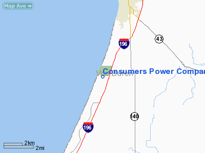
Consumers Power Company Heliport |
Location & QuickFacts
| FAA Information Effective: | 2008-09-25 |
| Airport Identifier: | 8MI5 |
| Airport Status: | Operational |
| Longitude/Latitude: | 086-18-17.0980W/42-19-38.1190N
-86.304749/42.327255 (Estimated) |
| Elevation: | 610 ft / 185.93 m (Estimated) |
| Land: | 1 acres |
| From nearest city: | 6 nautical miles SW of South Haven, MI |
| Location: | Van Buren County, MI |
| Magnetic Variation: | 03W (1985) |
Owner & Manager
| Ownership: | Privately owned |
| Owner: | Consumers Power Company |
| Address: | 212 W Michigan Avenue
Jackson, MI 49201 |
| Phone number: | 517-788-0360 |
| Manager: | R. W. Montross |
| Address: | Rt 2, Box 154
Covert, MI 49043 |
| Phone number: | 616-764-8913 |
Airport Operations and Facilities
| Airport Use: | Private
PERSONAL USE. |
| Segmented Circle: | No |
| Control Tower: | No |
| Landing fee charge: | No |
| Sectional chart: | Chicago |
| Region: | AGL - Great Lakes |
| Boundary ARTCC: | ZAU - Chicago |
| Tie-in FSS: | LAN - Lansing |
| FSS on Airport: | No |
| FSS Toll Free: | 1-800-WX-BRIEF |
Runway Information
Helipad H1
| Dimension: | 40 x 40 ft / 12.2 x 12.2 m |
| Surface: | CONC, |
| |
Runway H1 |
Runway |
| Traffic Pattern: | Left | Left |
|
Radio Navigation Aids
| ID |
Type |
Name |
Ch |
Freq |
Var |
Dist |
| HLM | NDB | Holland | | 233.00 | 03W | 28.9 nm |
| HAI | NDB | Three Rivers | | 407.00 | 02W | 38.8 nm |
| MGC | NDB | Michigan City | | 203.00 | 01W | 43.7 nm |
| IRS | NDB | Sturgis | | 382.00 | 04W | 49.6 nm |
| BT | NDB | Batol | | 272.00 | 04W | 49.8 nm |
| PMM | VOR/DME | Pullman | 058X | 112.10 | 00E | 12.2 nm |
| ELX | VOR/DME | Keeler | 113X | 116.60 | 00E | 13.7 nm |
| AZO | VOR/DME | Kalamazoo | 027X | 109.00 | 01W | 33.9 nm |
| GRR | VOR/DME | Grand Rapids | 106Y | 115.95 | 04W | 45.2 nm |
| GIJ | VORTAC | Gipper | 101X | 115.40 | 00E | 33.6 nm |
| BTL | VORTAC | Battle Creek | 031X | 109.40 | 02W | 46.8 nm |
| GSH | VORTAC | Goshen | 084X | 113.70 | 00E | 49.8 nm |
Remarks
- NO NIGHT OPERATIONS.
- APP/DEP OPNS CONDUCTED IN AREA 050-070 DEG & 170-190 DEG CLKWS; AREA APROPLY MKD, WIND INDCR MAINTD; NO NGT OPNS UNTIL PAD & WIND INDCR LGTD & BCN INSTALLED.
Images and information placed above are from
http://www.airport-data.com/airport/8MI5/
We thank them for the data!
| General Info
|
| Country |
United States
|
| State |
MICHIGAN
|
| FAA ID |
8MI5
|
| Latitude |
42-19-38.119N
|
| Longitude |
086-18-17.098W
|
| Elevation |
610 feet
|
| Near City |
SOUTH HAVEN
|
We don't guarantee the information is fresh and accurate. The data may
be wrong or outdated.
For more up-to-date information please refer to other sources.
|
|


