|
|
|
 |
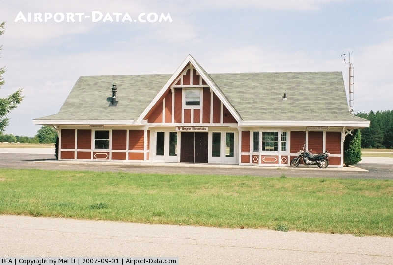
(Click on the photo to enlarge) |
Location & QuickFacts
| FAA Information Effective: | 2008-09-25 |
| Airport Identifier: | BFA |
| Airport Status: | Operational |
| Longitude/Latitude: | 084-55-26.8100W/45-09-57.0295N
-84.924114/45.165842 (Estimated) |
| Elevation: | 719 ft / 219.15 m (Surveyed) |
| Land: | 260 acres |
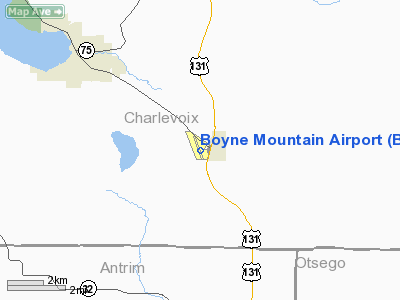
| From nearest city: | 1 nautical miles W of Boyne Falls, MI |
| Location: | Charlevoix County, MI |
| Magnetic Variation: | 06W (2000) |
Owner & Manager
| Ownership: | Privately owned |
| Owner: | Boyne Usa Inc |
| Address: | #1 Boyne Mtn
Boyne Falls, MI 49713 |
| Phone number: | 231-549-6001 |
| Manager: | Dave Newman |
| Address: | Boyne Mountain Lodge, Box 19
Boyne Falls, MI 49713 |
| Phone number: | 231-549-6000 |
Airport Operations and Facilities
| Airport Use: | Open to public |
| Wind indicator: | Yes |
| Segmented Circle: | Yes |
| Control Tower: | No |
| Lighting Schedule: | RDO-CTL
ACTVT LIRL RY 17/35; & REIL RYS 17 & 35 - 122.85. |
| Landing fee charge: | No |
| Sectional chart: | Lake Huron |
| Region: | AGL - Great Lakes |
| Boundary ARTCC: | ZMP - Minneapolis |
| Tie-in FSS: | LAN - Lansing |
| FSS on Airport: | No |
| FSS Toll Free: | 1-800-WX-BRIEF |
| NOTAMs Facility: | LAN (NOTAM-d service avaliable) |
Airport Communications
| CTAF: | 122.800 |
| Unicom: | 122.800 |
Airport Services
| Fuel available: | 100LLA
FOR FUEL CALL 231-549-6000. |
Runway Information
Runway 17/35
| Dimension: | 5187 x 60 ft / 1581.0 x 18.3 m
HAS 10' PAVED SHOULDER EACH SIDE; LAST 4700' RY 35. |
| Surface: | ASPH, Poor Condition
RY PAVEMENT - EXTENSIVE CRACKING. |
| Edge Lights: | Non-standard lighting system
RY 17/35 NSTD LIRL, 80' FM RY EDGES. RY HAS REFLECTORS SUMMER MONTHS |
| |
Runway 17 |
Runway 35 |
| Longitude: | 084-55-33.5500W | 084-55-20.0700W |
| Latitude: | 45-10-22.1890N | 45-09-31.8700N |
| Elevation: | 703.00 ft | 719.00 ft |
| Alignment: | 127 | 127 |
| Traffic Pattern: | Left | Left |
| Markings: | Non-precision instrument, Poor Condition | Non-precision instrument, Poor Condition |
| Displaced threshold: | 300.00 ft | 500.00 ft |
| Runway End Identifier: | Yes | Yes |
| Obstruction: | 15 ft road, 125 ft left of centerline
RWY 17 APCH RATIO 25:1 AT DSPLCD THLD BASED ON 70 FT TREES 1750 FT DSTC 140 FT R.
+15 FT ROAD 0 FT DSTC 125 FT L. | 50 ft trees, 201.0 ft from runway, 130 ft right of centerline
APCH RATIO 14:1 AT DSPLCD THLD; 38 FT TREES 540 FT FM DSPLCD THLD 170 FT R; APCH RATIO 20:1 BASED ON STRAIGHT OUT. |
|
Radio Navigation Aids
| ID |
Type |
Name |
Ch |
Freq |
Var |
Dist |
| BFA | NDB | Boyne Falls | | 263.00 | 06W | 0.1 nm |
| CVX | NDB | Charlevoix | | 392.00 | 05W | 16.8 nm |
| CXK | NDB | Clam Lake | | 251.00 | 05W | 20.9 nm |
| GYG | NDB | Grayling | | 359.00 | 06W | 25.3 nm |
| TV | NDB | Gwenn | | 365.00 | 05W | 33.7 nm |
| SJX | NDB | St James | | 382.00 | 05W | 41.5 nm |
| PZQ | NDB | Rogers City | | 215.00 | 07W | 48.8 nm |
| CGG | VOR | Grayling | | 109.80 | 06W | 30.3 nm |
| GLR | VOR/DME | Gaylord | 029X | 109.20 | 06W | 13.1 nm |
| HTL | VOR/DME | Houghton Lake | 053X | 111.60 | 05W | 49.7 nm |
| PLN | VORTAC | Pellston | 055X | 111.80 | 06W | 30.0 nm |
| TVC | VORTAC | Traverse City | 093X | 114.60 | 02W | 40.1 nm |
Remarks
- DEER & BIRDS ON & INVOF ARPT.
- PRIOR TO 1959.
Images and information placed above are from
http://www.airport-data.com/airport/BFA/
We thank them for the data!
| General Info
|
| Country |
United States
|
| State |
MICHIGAN
|
| FAA ID |
BFA
|
| Latitude |
45-09-57.033N
|
| Longitude |
084-55-26.600W
|
| Elevation |
719 feet
|
| Near City |
BOYNE FALLS
|
We don't guarantee the information is fresh and accurate. The data may
be wrong or outdated.
For more up-to-date information please refer to other sources.
|
|