 |
|
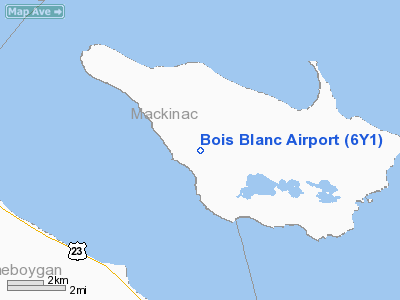
Location & QuickFacts
| FAA Information Effective: | 2008-09-25 |
| Airport Identifier: | 6Y1 |
| Airport Status: | Operational |
| Longitude/Latitude: | 084-30-13.6700W/45-45-58.7700N
-84.503797/45.766325 (Estimated) |
| Elevation: | 664 ft / 202.39 m (Surveyed) |
| Land: | 130 acres |
| From nearest city: | 3 nautical miles NW of Pointe Aux Pins, MI |
| Location: | Mackinac County, MI |
| Magnetic Variation: | 06W (1985) |
Owner & Manager
| Ownership: | Publicly owned |
| Owner: | Bois Blanc Township |
| Address: | P.o. Box 898
Point Aux Pins, MI 49775-0898 |
| Phone number: | 231-634-7275
TOWN HALL |
| Manager: | Gregg Dickerson |
| Address: | Hcr -1 Box 351
Pointe Aux Pins, MI 49775 |
| Phone number: | 231-634-7123 |
Airport Operations and Facilities
| Airport Use: | Open to public |
| Wind indicator: | Yes |
| Segmented Circle: | Yes |
| Control Tower: | No |
| Lighting Schedule: | DUSK-DAWN
ACTVT MIRL RY 10/28 - CTAF. |
| Beacon Color: | Clear-Green (lighted land airport) |
| Landing fee charge: | No |
| Sectional chart: | Lake Huron |
| Region: | AGL - Great Lakes |
| Boundary ARTCC: | ZMP - Minneapolis |
| Tie-in FSS: | LAN - Lansing |
| FSS on Airport: | No |
| FSS Toll Free: | 1-800-WX-BRIEF |
| NOTAMs Facility: | LAN (NOTAM-d service avaliable) |
Airport Communications
Airport Services
Runway Information
Runway 10/28
| Dimension: | 3500 x 75 ft / 1066.8 x 22.9 m |
| Surface: | ASPH, Good Condition |
| Edge Lights: | Medium |
| |
Runway 10 |
Runway 28 |
| Longitude: | 084-30-38.3000W | 084-29-49.2000W |
| Latitude: | 45-46-00.5000N | 45-45-57.0000N |
| Elevation: | 0.00 ft | 653.00 ft |
| Traffic Pattern: | Left | Left |
| Markings: | Basic, Good Condition | Basic, Good Condition |
| Crossing Height: | 0.00 ft | 33.00 ft |
| Displaced threshold: | 90.00 ft | 0.00 ft |
| VASI: | | 4-light PAPI on left side |
| Visual Glide Angle: | 0.00° | 4.00° |
| Runway End Identifier: | No | Yes |
| Centerline Lights: | No | No |
| Touchdown Lights: | No | No |
| Obstruction: | 70 ft trees, 1310.0 ft from runway, 15:1 slope to clear
APCH RATIO 20:1 AT DSPLCD THR. | 5 ft trees, 260.0 ft from runway, 125 ft left of centerline, 12:1 slope to clear |
|
Radio Navigation Aids
| ID |
Type |
Name |
Ch |
Freq |
Var |
Dist |
| CI | NDB | Koloe | | 400.00 | 06W | 34.1 nm |
| DRM | NDB | Drummond Island | | 218.00 | 07W | 35.0 nm |
| PZQ | NDB | Rogers City | | 215.00 | 07W | 36.0 nm |
| BFA | NDB | Boyne Falls | | 263.00 | 06W | 40.1 nm |
| CVX | NDB | Charlevoix | | 392.00 | 05W | 42.7 nm |
| SJX | NDB | St James | | 382.00 | 05W | 44.5 nm |
| A | NDB | Gros Cap | | 286.00 | 06W | 45.1 nm |
| SSM | VOR/DME | Sault Ste Marie | 059X | 112.20 | 04W | 39.6 nm |
| GLR | VOR/DME | Gaylord | 029X | 109.20 | 06W | 46.1 nm |
| PLN | VORTAC | Pellston | 055X | 111.80 | 06W | 10.6 nm |
Remarks
- DEER & BIRDS ON & INVOF ARPT.
Images and information placed above are from
http://www.airport-data.com/airport/6Y1/
We thank them for the data!
| General Info
|
| Country |
United States
|
| State |
MICHIGAN
|
| FAA ID |
6Y1
|
| Latitude |
45-46-00.047N
|
| Longitude |
084-30-00.139W
|
| Elevation |
653 feet
|
| Near City |
POINTE AUX PINS
|
We don't guarantee the information is fresh and accurate. The data may
be wrong or outdated.
For more up-to-date information please refer to other sources.
|
|


