 |
|
Location & QuickFacts
| FAA Information Effective: | 2008-09-25 |
| Airport Identifier: | 4MI9 |
| Airport Status: | Operational |
| Longitude/Latitude: | 084-02-56.5000W/41-54-46.0000N
-84.049028/41.912778 (Estimated) |
| Elevation: | 825 ft / 251.46 m (Estimated) |
| Land: | 40 acres |
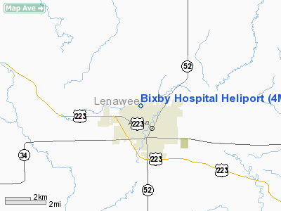
| From nearest city: | 0 nautical miles N of Adrian, MI |
| Location: | Lenawee County, MI |
| Magnetic Variation: | 06W (2000) |
Owner & Manager
| Ownership: | Privately owned |
| Owner: | Bixby Medical Center |
| Address: | 818 Riverside Ave
Adrian, MI 49221 |
| Phone number: | 517-263-0711 |
| Manager: | Mr. Norman Spenser |
| Address: | 818 Riverside Ave
Adrian, MI 49221 |
| Phone number: | 517-263-0711 |
Airport Operations and Facilities
| Airport Use: | Private
MEDICAL USE. |
| Wind indicator: | Yes |
| Segmented Circle: | No |
| Control Tower: | No |
| Lighting Schedule: | PHONE REQ
FOR ROTG BCN; PERIMETER & FLOOD LGTS CALL 517-263-0711 15 MINS BEFORE ETA. |
| Beacon Color: | Clear-Green-Yellow (heliport) |
| Landing fee charge: | No |
| Sectional chart: | Detroit |
| Region: | AGL - Great Lakes |
| Boundary ARTCC: | ZOB - Cleveland |
| Tie-in FSS: | LAN - Lansing |
| FSS on Airport: | No |
| FSS Toll Free: | 1-800-WX-BRIEF |
Runway Information
Helipad H1
| Dimension: | 40 x 40 ft / 12.2 x 12.2 m |
| Surface: | CONC, |
| |
Runway H1 |
Runway |
| Traffic Pattern: | Left | Left |
|
Radio Navigation Aids
| ID |
Type |
Name |
Ch |
Freq |
Var |
Dist |
| ADG | NDB | Adrian | | 278.00 | 06W | 2.9 nm |
| TCU | NDB | Tecumseh | | 239.00 | 04W | 10.6 nm |
| USE | NDB | Fulton | | 375.00 | 05W | 18.6 nm |
| BYN | NDB | Bryan | | 260.00 | 04W | 32.1 nm |
| DFI | NDB | Defiance | | 246.00 | 05W | 38.7 nm |
| RYS | NDB | Grosse Ile | | 419.00 | 06W | 41.6 nm |
| OZW | NDB | Howell | | 243.00 | 05W | 43.4 nm |
| G | NDB | Golf | | 398.00 | 05W | 48.9 nm |
| ANQ | NDB | Angola | | 347.00 | 05W | 49.3 nm |
| TOL | TACAN | Toledo | 072X | | 05W | 22.2 nm |
| JXN | VOR/DME | Jackson | 033X | 109.60 | 05W | 27.7 nm |
| LFD | VOR/DME | Litchfield | 049X | 111.20 | 05W | 33.2 nm |
| VWV | VOR/DME | Waterville | 078X | 113.10 | 02W | 33.3 nm |
| DXO | VOR/DME | Detroit | 081X | 113.40 | 06W | 35.4 nm |
| CRL | VORTAC | Carleton | 104X | 115.70 | 03W | 27.6 nm |
| SVM | VORTAC | Salem | 090X | 114.30 | 03W | 36.1 nm |
| YIP | VOT | Willow Run | | 112.00 | | 30.4 nm |
| DTW | VOT | Detroit Met Wayne | | 109.80 | | 35.9 nm |
Remarks
- (E111-1) E111 CONT'D: & A HELI IDENT BCN IS INSTALLED & OPNL; DURG DALGT HRS ONLY OPNS IN AN AREA FROM 350-030 DEGS CLKWS; SCTY INSURES NORTH/SOUTH ROAD...
- (E111-2) E111 CONT'D: ALONG EAST SIDE OF HOSPITAL IS FREE OF VEHICULAR & PEDESTRIAN TFC; TKOF/LNDG AREA IS APROPLY MKD & LGTD;
- PROVIDING ALL APCH/DEP OPS 010-080 DEGS & 260-295 DEGS; TKOF/LNDG AREA APPROPRIATELY MKD; NON-OBSTN WIND INDICATOR MAINTAINED; PLINES ADJ TO LNDG AREA LATERAL CLNC PLANE ON SOUTH SIDE ARE OBST MKD. E111 CONT'D: NON-OBSTNG WIND INDCR IS MAINTD ADJ TO TKOF/LNDG AREA.
Images and information placed above are from
http://www.airport-data.com/airport/4MI9/
We thank them for the data!
| General Info
|
| Country |
United States
|
| State |
MICHIGAN
|
| FAA ID |
4MI9
|
| Latitude |
41-54-46.000N
|
| Longitude |
084-02-56.500W
|
| Elevation |
825 feet
|
| Near City |
ADRIAN
|
We don't guarantee the information is fresh and accurate. The data may
be wrong or outdated.
For more up-to-date information please refer to other sources.
|
|


