 |
|
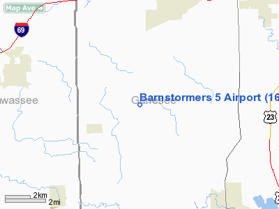
Location & QuickFacts
| FAA Information Effective: | 2008-09-25 |
| Airport Identifier: | 16MI |
| Airport Status: | Operational |
| Longitude/Latitude: | 083-51-59.8470W/42-53-21.0000N
-83.866624/42.889167 (Estimated) |
| Elevation: | 823 ft / 250.85 m (Estimated) |
| Land: | 12 acres |
| From nearest city: | 3 nautical miles NE of Gaines, MI |
| Location: | Genesee County, MI |
| Magnetic Variation: | 05W (1985) |
Owner & Manager
| Ownership: | Privately owned |
| Owner: | James F. Brichan |
| Address: | 9307 Vanvleet Rd
Gaines, MI 48436 |
| Phone number: | 517-271-8651 |
| Manager: | James F. Brichan |
| Address: | 9307 Vanvleet Rd
Gaines, MI 48436 |
| Phone number: | 517-271-8651 |
Airport Operations and Facilities
| Airport Use: | Private |
| Wind indicator: | Yes |
| Segmented Circle: | No |
| Control Tower: | No |
| Sectional chart: | Detroit |
| Region: | AGL - Great Lakes |
| Boundary ARTCC: | ZOB - Cleveland |
| Tie-in FSS: | LAN - Lansing |
| FSS Toll Free: | 1-800-WX-BRIEF |
Airport Services
Runway Information
Runway 09/27
| Dimension: | 1300 x 80 ft / 396.2 x 24.4 m |
| Surface: | TURF, |
| |
Runway 09 |
Runway 27 |
| Traffic Pattern: | Left | Right |
| Displaced threshold: | 300.00 ft | 400.00 ft |
| Obstruction: | | 20 ft trees, 0.0 ft from runway |
|
Radio Navigation Aids
| ID |
Type |
Name |
Ch |
Freq |
Var |
Dist |
| OZW | NDB | Howell | | 243.00 | 05W | 16.2 nm |
| HYX | NDB | Browne | | 385.00 | 06W | 32.6 nm |
| AMN | NDB | Alma | | 329.00 | 05W | 48.0 nm |
| MTC | TACAN | Selfridge | 064X | | 06W | 48.6 nm |
| MBS | VOR/DME | Saginaw | 076X | 112.90 | 03W | 39.7 nm |
| JXN | VOR/DME | Jackson | 033X | 109.60 | 05W | 46.0 nm |
| DXO | VOR/DME | Detroit | 081X | 113.40 | 06W | 46.3 nm |
| FNT | VORTAC | Flint | 116X | 116.90 | 06W | 7.0 nm |
| PSI | VORTAC | Pontiac | 047X | 111.00 | 03W | 18.6 nm |
| SVM | VORTAC | Salem | 090X | 114.30 | 03W | 31.3 nm |
| LAN | VORTAC | Lansing | 045X | 110.80 | 05W | 38.1 nm |
| YIP | VOT | Willow Run | | 112.00 | | 42.2 nm |
| DTW | VOT | Detroit Met Wayne | | 109.80 | | 45.5 nm |
| DET | VOT | Detroit City | | 111.60 | | 47.5 nm |
Images and information placed above are from
http://www.airport-data.com/airport/16MI/
We thank them for the data!
| General Info
|
| Country |
United States
|
| State |
MICHIGAN
|
| FAA ID |
16MI
|
| Latitude |
42-53-15.106N
|
| Longitude |
083-51-59.847W
|
| Elevation |
820 feet
|
| Near City |
GAINES
|
We don't guarantee the information is fresh and accurate. The data may
be wrong or outdated.
For more up-to-date information please refer to other sources.
|
|


