 |
|
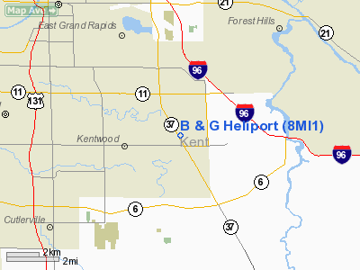
Location & QuickFacts
| FAA Information Effective: | 2008-09-25 |
| Airport Identifier: | 8MI1 |
| Airport Status: | Operational |
| Longitude/Latitude: | 085-34-04.0880W/42-53-21.1060N
-85.567802/42.889196 (Estimated) |
| Elevation: | 755 ft / 230.12 m (Estimated) |
| Land: | 3 acres |
| From nearest city: | 6 nautical miles SE of Grand Rapids, MI |
| Location: | Kent County, MI |
| Magnetic Variation: | 04W (1985) |
Owner & Manager
| Ownership: | Privately owned |
| Owner: | B & G Products, Inc |
| Address: | 4150 Broadmoor, Se.
Kentwood, MI 49512 |
| Phone number: | 616-698-9050 |
| Manager: | Paul Geddes |
| Address: | 4150 Broadmoor, Se.
Kentwood, MI 49512 |
| Phone number: | 616-698-9050 |
Airport Operations and Facilities
| Airport Use: | Private |
| Wind indicator: | Yes |
| Segmented Circle: | No |
| Control Tower: | No |
| Sectional chart: | Chicago |
| Region: | AGL - Great Lakes |
| Boundary ARTCC: | ZAU - Chicago |
| Tie-in FSS: | LAN - Lansing |
| FSS Toll Free: | 1-800-WX-BRIEF |
Runway Information
Helipad H1
| Dimension: | 50 x 50 ft / 15.2 x 15.2 m |
| Surface: | ASPH, |
| |
Runway H1 |
Runway |
| Traffic Pattern: | Left | Left |
| Obstruction: | 60 ft poles, 75.0 ft from runway | |
|
Radio Navigation Aids
| ID |
Type |
Name |
Ch |
Freq |
Var |
Dist |
| HLM | NDB | Holland | | 233.00 | 03W | 26.6 nm |
| BT | NDB | Batol | | 272.00 | 04W | 35.9 nm |
| AMN | NDB | Alma | | 329.00 | 05W | 43.1 nm |
| GRR | VOR/DME | Grand Rapids | 106Y | 115.95 | 04W | 6.9 nm |
| PMM | VOR/DME | Pullman | 058X | 112.10 | 00E | 34.8 nm |
| AZO | VOR/DME | Kalamazoo | 027X | 109.00 | 01W | 39.2 nm |
| HIC | VOR/DME | White Cloud | 123X | 117.60 | 01W | 41.7 nm |
| MKG | VORTAC | Muskegon | 099X | 115.20 | 01W | 26.7 nm |
| BTL | VORTAC | Battle Creek | 031X | 109.40 | 02W | 37.5 nm |
| LAN | VORTAC | Lansing | 045X | 110.80 | 05W | 39.7 nm |
Remarks
- NO STUDENT PILOTS.
- HELIPORT ADJACENT TO GRAND RAPIDS KENT COUNTY INTL. ACFT MUST MAINTAIN CTC WITH GRR ATCT.
- NO SNOW REMOVAL.
- +25' BLDG ADJACENT
- PRVD INGRESS/EGRESS ARE PRVD & ALL PILOTS USING THE HELIPORT ARE ADVISED OF THE NEW BLDG ADDITION; ANY INGRESS/EGRESS ROUTES EXISTING OVER THE PRESENT BLDG ADDITION MUST BE CONSIDERED INVALID.
Images and information placed above are from
http://www.airport-data.com/airport/8MI1/
We thank them for the data!
| General Info
|
| Country |
United States
|
| State |
MICHIGAN
|
| FAA ID |
8MI1
|
| Latitude |
42-53-21.106N
|
| Longitude |
085-34-04.088W
|
| Elevation |
755 feet
|
| Near City |
GRAND RAPIDS
|
We don't guarantee the information is fresh and accurate. The data may
be wrong or outdated.
For more up-to-date information please refer to other sources.
|
|


