 |
|
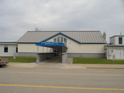
Alpena County Regional Airport |
| Alpena County Regional Airport |
 |
| IATA: APN – ICAO: KAPN – FAA LID: APN |
| Summary |
| Airport type |
Public |
| Owner |
County of Alpena |
| Serves |
Alpena, Michigan |
| Location |
Maple Ridge Township/
Wilson Township |
| Elevation AMSL |
690 ft / 210 m |
| Coordinates |
45°04′41″N 083°33′37″W / 45.07806°N 83.56028°W / 45.07806; -83.56028 |
| Website |
AlpenaAirport.com |
| Runways |
| Direction |
Length |
Surface |
| ft |
m |
| 1/19 |
9,001 |
2,744 |
Concrete |
| 7/25 |
5,028 |
1,533 |
Concrete |
| Statistics (2007) |
| Aircraft operations |
15,595 |
| Based aircraft |
23 |
| Source: Federal Aviation Administration |
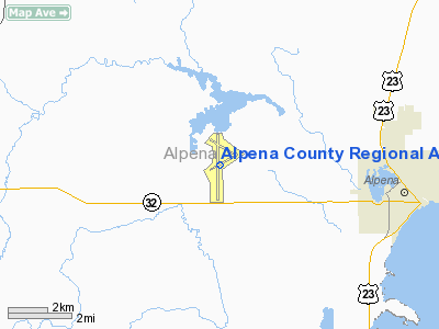
Alpena County Regional Airport (ICAO: KAPN, FAA LID: APN) is a county-owned public-use airport in Alpena County, Michigan, United States. The airport is located six nautical miles (11 km) west of the central business district of Alpena, off of M-32 . It straddles the boundary between Maple Ridge Township on the north and Wilson Township on the south. It is mostly used for general aviation, but is also served by one commercial airline, Delta Air Lines.
It is said to be the "Proud home of Alpena Combat Readiness Training Center."
Several scenes of the film Die Hard 2 were shot there. History
During World War II the airfield was used by the United States Army Air Force, operated by the 4250th Army Air Force Base Unit, which also operated Kinross Auxiliary Air Field (later Kincheloe Air Force Base.)
Facilities and aircraft
Alpena County Regional Airport covers an area of 3,084 acres (1,248 ha) at an elevation of 690 feet (210 m) above mean sea level. It has two concrete paved runways: 1/19 is 9,001 by 150 feet (2,744 x 46 m) and 7/25 is 5,028 by 100 feet (1,533 x 30 m).
For the 12-month period ending December 31, 2007, the airport had 15,595 aircraft operations, an average of 42 per day: 35% general aviation, 26% air taxi, 25% military, and 15% scheduled commercial. At that time there were 23 aircraft based at this airport: 74% single-engine, 17% multi-engine, 4% helicopter and 4% military.
Airlines and destinations
| Airlines |
Destinations |
Delta Connection
operated by Mesaba Airlines |
Detroit, Sault Ste. Marie |
The above content comes from Wikipedia and is published under free licenses – click here to read more.
Location & QuickFacts
| FAA Information Effective: | 2008-09-25 |
| Airport Identifier: | APN |
| Airport Status: | Operational |
| Longitude/Latitude: | 083-33-37.0290W/45-04-41.0430N
-83.560286/45.078068 (Estimated) |
| Elevation: | 689 ft / 210.01 m (Surveyed) |
| Land: | 3084 acres |
| From nearest city: | 6 nautical miles W of Alpena, MI |
| Location: | Alpena County, MI |
| Magnetic Variation: | 07W (1985) |
Owner & Manager
| Ownership: | Publicly owned |
| Owner: | County Of Alpena |
| Address: | 1617 Airport Rd
Alpena, MI 49707 |
| Phone number: | 989-354-2907 |
| Manager: | Ms. Billi Mcroberts |
| Address: | 1617 Airport Rd
Alpena, MI 49707 |
| Phone number: | 989-354-2907 |
Airport Operations and Facilities
| Airport Use: | Open to public |
| Wind indicator: | Yes |
| Segmented Circle: | Yes |
| Control Tower: | Yes |
| Lighting Schedule: | DUSK-DAWN
ACTVT HIRL RY 01/19; MIRL RY 07/25; REIL RYS 19; 07 & 25; MALSR RY 01 - CTAF. |
| Beacon Color: | Clear-Green (lighted land airport) |
| Landing fee charge: | Yes |
| Sectional chart: | Lake Huron |
| Region: | AGL - Great Lakes |
| Boundary ARTCC: | ZMP - Minneapolis |
| Tie-in FSS: | LAN - Lansing |
| FSS on Airport: | No |
| FSS Toll Free: | 1-800-WX-BRIEF |
| NOTAMs Facility: | APN (NOTAM-d service avaliable) |
| Certification type/date: | I A S 05/1973
48 HRS PPR FOR ACR OPNS WITH MORE THAN 30 PSGR SEATS - CALL AMGR 989-354-2907. |
| Federal Agreements: | NGPY |
Airport Communications
| CTAF: | 121.350 |
| Unicom: | 122.950 |
Airport Services
| Fuel available: | 100LLA |
| Airframe Repair: | MINOR |
| Power Plant Repair: | MINOR |
| Bottled Oxygen: | NONE |
| Bulk Oxygen: | NONE |
Runway Information
Runway 01/19
| Dimension: | 9001 x 150 ft / 2743.5 x 45.7 m |
| Surface: | CONC, Good Condition |
| Surface Treatment: | Saw-cut or plastic Grooved |
| Weight Limit: | Single wheel: 65000 lbs.
Dual wheel: 95000 lbs.
Dual tandem wheel: 175000 lbs. |
| Edge Lights: | High |
| |
Runway 01 |
Runway 19 |
| Longitude: | 083-33-40.9350W | 083-33-41.3680W |
| Latitude: | 45-03-53.7790N | 45-05-22.6460N |
| Elevation: | 683.00 ft | 683.00 ft |
| Alignment: | 127 | 127 |
| ILS Type: | ILS
| |
| Traffic Pattern: | Left | Left |
| Markings: | Precision instrument, Good Condition | Precision instrument, Good Condition |
| Arresting: | BAK14 | BAK12 |
| Crossing Height: | 52.00 ft | 36.00 ft |
| VASI: | 4-light PAPI on left side | 4-light PAPI on left side |
| Visual Glide Angle: | 3.00° | 3.00° |
| Approach lights: | MALSR | |
| Runway End Identifier: | No | Yes |
| Centerline Lights: | No | No |
| Touchdown Lights: | No | No |
| Obstruction: | 68 ft tree, 3190.0 ft from runway, 329 ft right of centerline, 43:1 slope to clear | 56 ft tree, 2174.0 ft from runway, 440 ft right of centerline, 35:1 slope to clear |
|
Runway 07/25
| Dimension: | 5031 x 100 ft / 1533.4 x 30.5 m |
| Surface: | CONC, Fair Condition |
| Surface Treatment: | Saw-cut or plastic Grooved |
| Weight Limit: | Single wheel: 65000 lbs.
Dual wheel: 95000 lbs.
Dual tandem wheel: 175000 lbs. |
| Edge Lights: | Medium |
| |
Runway 07 |
Runway 25 |
| Longitude: | 083-34-00.1470W | 083-32-59.5500W |
| Latitude: | 45-04-33.7200N | 45-04-58.7000N |
| Elevation: | 689.00 ft | 679.00 ft |
| Alignment: | 60 | 127 |
| Traffic Pattern: | Left | Left |
| Markings: | Non-precision instrument, Good Condition | Non-precision instrument, Good Condition |
| Crossing Height: | 40.00 ft | 40.00 ft |
| VASI: | 4-light PAPI on left side | 4-light PAPI on left side |
| Visual Glide Angle: | 3.00° | 3.00° |
| Runway End Identifier: | Yes | Yes |
| Centerline Lights: | No | No |
| Touchdown Lights: | No | No |
| Obstruction: | 41 ft trees, 809.0 ft from runway, 295 ft right of centerline, 14:1 slope to clear | 80 ft trees, 2866.0 ft from runway, 427 ft left of centerline, 33:1 slope to clear |
|
Radio Navigation Aids
| ID |
Type |
Name |
Ch |
Freq |
Var |
Dist |
| PZQ | NDB | Rogers City | | 215.00 | 07W | 22.5 nm |
| ASP | VOR/DME | Au Sable | 108X | 116.10 | 07W | 38.5 nm |
| GLR | VOR/DME | Gaylord | 029X | 109.20 | 06W | 48.7 nm |
| APN | VORTAC | Alpena | 025X | 108.80 | 07W | 0.3 nm |
Remarks
- RYS 01 & 19 EACH HAVE 1000' OVRN.
- RY 01/19 BAK 12/14; RY 01-1500 FT FM THLD & RY 19 - 1515 FT FM THLD.
- TWY 'A' WEST OF TWY 'C' AND TWY 'B' RESTRICTED TO MILITARY ONLY. BE ALERT FOR UNCONTROLLED VEHICLES ON THE TWY. TWY TO MAINTENANCE HANGARS UNLIT.
- TWY H, EAST OF RWY 01/19 AVAILABLE FOR MILITARY USE ONLY.
- BIRDS & OTHER WILDLIFE ON & INVOF ARPT.
- ANG - 72 HR PPR; CTC BASOPS DSN 741-3226 OR COML 989-354-6226 FOR PPR NR.
- ANG DUTY HRS 0800-1630 MON - FRI EXCEPT HOLIDAYS.
Images and information placed above are from
http://www.airport-data.com/airport/APN/
We thank them for the data!
| General Info
|
| Country |
United States
|
| State |
MICHIGAN
|
| FAA ID |
APN
|
| Latitude |
45-04-41.043N
|
| Longitude |
083-33-37.029W
|
| Elevation |
689 feet
|
| Near City |
ALPENA
|
We don't guarantee the information is fresh and accurate. The data may
be wrong or outdated.
For more up-to-date information please refer to other sources.
|
|


