 |
|
| Cranland Airport |
| IATA: 28M – ICAO: K28M |
| Summary |
| Airport type |
Public |
| Operator |
Cranland Airport Inc. |
| Location |
Hanson, Massachusetts |
| Elevation AMSL |
71 ft / 22 m |
| Coordinates |
42°01′30.5″N 70°50′17.2″W / 42.025139°N 70.838111°W / 42.025139; -70.838111Coordinates: 42°01′30.5″N 70°50′17.2″W / 42.025139°N 70.838111°W / 42.025139; -70.838111 |
| Runways |
| Direction |
Length |
Surface |
| ft |
m |
| 18/36 |
1860 |
567 |
Asphalt |
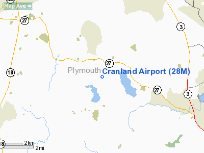
Cranland Airport, (IATA: 28M, ICAO: K28M) in Hanson, Massachusetts, is a public airport owned by Cranland Airport Inc. It has one runway, averages 102 flights per week, and has approximately 22 aircraft based on its field. One historic aircraft, a Grumman Widgeon which was formerly owned by singer Jimmy Buffett (then registered as N1471N) is housed in the main hangar and is now owned by Dennis K Burke, who eventually became the sole owner of the Cranland airport. Dennis re-registered the aircraft as N3N. The Cranland airport is also the home of the EAA chapter 279. EAA stands for Experimental Aircraft Association.
On 8-1-2007 a small plane crashed 40 yards from the runway, the only death was the pilot; a 63 year old man.
The above content comes from Wikipedia and is published under free licenses – click here to read more.
|
Location & QuickFacts
|
FAA
Information Effective: |
2008-09-25 |
|
Airport Identifier: |
28M |
|
Airport Status: |
Operational |
|
Longitude/Latitude: |
070-50-17.2000W/42-01-30.5000N
-70.838111/42.025139 (Estimated) |
|
Elevation: |
71 ft / 21.64 m (Estimated) |
|
Land: |
100 acres |
|
From
nearest city: |
3 nautical miles SE of Hanson, MA |
|
Location: |
Plymouth County, MA |
|
Magnetic Variation: |
16W (1985) |
Owner & Manager
|
Ownership: |
Privately owned |
|
Owner: |
Cranland Airport Inc. |
|
Address: |
777 Monponsett Street
Hanson, MA 02341 |
|
Manager: |
Peter Annis |
|
Address: |
87 Cedar Lane
Halifax, MA 02338 |
|
Phone number: |
781-293-2181 |
Airport Operations and Facilities
|
Airport Use: |
Open to public |
|
Wind
indicator: |
Yes |
|
Segmented Circle: |
No |
|
Control Tower: |
No |
|
Landing fee charge: |
No |
|
Sectional chart: |
New York |
|
Region: |
ANE - New England |
|
Boundary ARTCC: |
ZBW - Boston |
|
Tie-in FSS: |
BDR - Bridgeport |
|
FSS
on Airport: |
No |
|
FSS
Toll Free: |
1-800-WX-BRIEF |
|
NOTAMs Facility: |
BDR (NOTAM-d service avaliable) |
Airport Communications
Airport Services
|
Fuel
available: |
100LL |
|
Airframe Repair: |
MINOR |
|
Power Plant Repair: |
MINOR |
|
Runway Information
Runway 18/36
|
Dimension: |
1860 x 60 ft / 566.9 x 18.3 m |
|
Surface: |
ASPH, Good Condition |
|
Weight
Limit: |
Single wheel: 8000 lbs. |
|
|
Runway 18
|
Runway 36
|
|
Longitude: |
070-50-20.3362W |
070-50-13.9859W |
|
Latitude: |
42-01-38.8728N |
42-01-22.1393N |
|
Elevation: |
70.00 ft |
70.00 ft |
|
Traffic Pattern: |
Left |
Left |
|
Obstruction: |
36 ft trees, 600.0 ft from runway, 130 ft left of centerline, 11:1
slope to clear |
33 ft trees, 800.0 ft from runway, 125 ft right of centerline, 18:1
slope to clear |
|
Radio Navigation Aids
|
ID |
Type |
Name |
Ch |
Freq |
Var |
Dist |
|
ORW |
FAN MARKER |
Canton |
|
|
15W |
16.2 nm |
|
BVY |
FAN MARKER |
Beverly |
|
|
|
35.5 nm |
|
IMR |
NDB |
Marshfield |
|
368.00 |
16W |
8.5 nm |
|
FFF |
NDB |
Plymouth |
|
257.00 |
16W |
10.8 nm |
|
TAN |
NDB |
Taunton |
|
227.00 |
16W |
12.0 nm |
|
IHM |
NDB |
Mansfield |
|
220.00 |
16W |
16.1 nm |
|
LQ |
NDB |
Lyndy |
|
382.00 |
16W |
26.3 nm |
|
PVC |
NDB |
Provincetown |
|
389.00 |
16W |
27.6 nm |
|
SFZ |
NDB |
Central |
|
241.00 |
15W |
29.8 nm |
|
SKR |
NDB |
Shaker Hill |
|
251.00 |
16W |
30.0 nm |
|
TOF |
NDB |
Topsfield |
|
269.00 |
16W |
36.1 nm |
|
CQX |
NDB |
Nauset |
|
279.00 |
16W |
42.9 nm |
|
NZW |
TACAN |
South Weymouth |
061X |
|
15W |
8.7 nm |
|
FMH |
TACAN |
Otis |
105X |
|
15W |
26.3 nm |
|
LFV |
VOR/DME |
Marconi |
094X |
114.70 |
16W |
35.8 nm |
|
MVY |
VOR/DME |
Marthas Vineyard |
092X |
114.50 |
15W |
39.1 nm |
|
LWM |
VOR/DME |
Lawrence |
072X |
112.50 |
15W |
44.5 nm |
|
PUT |
VOR/DME |
Putnam |
121X |
117.40 |
14W |
45.1 nm |
|
BOS |
VORTAC |
Boston |
074X |
112.70 |
16W |
21.1 nm |
|
PVD |
VORTAC |
Providence |
103X |
115.60 |
14W |
32.1 nm |
|
BOS |
VOT |
Boston Logan Intl |
|
111.00 |
|
22.7 nm |
|
PVD |
VOT |
Providence |
|
108.20 |
|
32.0 nm |
|
BED |
VOT |
Laurence G Hanscom Fld |
|
110.00 |
|
33.3 nm |
|
ORH |
VOT |
Worcester |
|
108.20 |
|
48.2 nm |
Remarks
-
NON-COMPLIANCE WITH FAR
157.
Based Aircraft
|
Aircraft
based on field: |
19 |
|
Single
Engine Airplanes: |
10 |
|
Multi
Engine Airplanes: |
2 |
|
Helicopters: |
1 |
|
Ultralights: |
6 |
Operational Statistics
Time
Period: 2007-03-03 - 2008-03-01
|
Aircraft
Operations: |
108/Week |
|
General
Aviation Local: |
67.9% |
|
General
Aviation Itinerant: |
32.1% |
Cranland Airport
Address:
Plymouth County, MA
Tel:
781-293-2181
Images
and information placed above are from
http://www.airport-data.com/airport/28M/
We
thank them for the data!
| General Info |
| Country |
United States |
| State |
MASSACHUSETTS |
| FAA ID |
28M |
| Latitude |
42-01-30.500N |
| Longitude |
070-50-17.200W |
| Elevation |
71 feet |
| Near City |
HANSON |
We don't guarantee the information is fresh and accurate. The data may
be wrong or outdated.
For more up-to-date information please refer to other sources.
|
|


