 |
|
|
Location & QuickFacts
|
FAA
Information Effective: |
2008-09-25 |
|
Airport Identifier: |
MA18 |
|
Airport Status: |
Operational |
|
Longitude/Latitude: |
073-18-25.8500W/42-04-44.7900N
-73.307181/42.079108 (Estimated) |
|
Elevation: |
980 ft / 298.70 m (Estimated) |
|
Land: |
0 acres |
|
From
nearest city: |
3 nautical miles NW of Sheffield, MA |
|
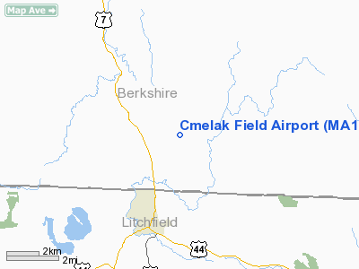
Location: |
Berkshire County, MA |
|
Magnetic Variation: |
() |
Owner & Manager
|
Ownership: |
Privately owned |
|
Owner: |
John R. Hanlon, Jr. |
|
Address: |
P.o. Box 808
Sheffield, MA 01257 |
|
Phone number: |
413-229-8417 |
|
Manager: |
John R. Hanlon, Jr. |
|
Address: |
P.o. Box 808
Sheffield, MA 01257 |
|
Phone number: |
413-229-8417 |
Airport Operations and
Facilities
|
Airport Use: |
Private |
|
Control Tower: |
No |
|
Sectional chart: |
New York |
|
Region: |
ANE - New England |
|
Boundary ARTCC: |
ZBW - Boston |
|
Tie-in FSS: |
BDR - Bridgeport |
|
FSS
Toll Free: |
1-800-WX-BRIEF |
|
Runway Information
Runway 16/34
|
Dimension: |
1250 x 80 ft / 381.0 x 24.4 m |
|
Surface: |
TURF, |
|
|
Runway 16
|
Runway 34
|
|
Traffic Pattern: |
Left |
Left |
|
Helipad H1
|
Dimension: |
100 x 100 ft / 30.5 x 30.5 m |
|
Surface: |
TURF, |
|
|
Runway H1
|
Runway
|
|
Traffic Pattern: |
Left |
Left |
|
Radio Navigation Aids
|
ID |
Type |
Name |
Ch |
Freq |
Var |
Dist |
|
GBR |
FAN MARKER |
Sheffield |
|
|
13W |
3.9 nm |
|
PSF |
FAN MARKER |
Abyss |
|
|
13W |
23.0 nm |
|
SKU |
FAN MARKER |
Stanwyck |
|
|
12W |
46.8 nm |
|
GBR |
NDB |
Great Barrington |
|
395.00 |
14W |
7.6 nm |
|
PFH |
NDB |
Philmont |
|
272.00 |
13W |
21.3 nm |
|
DXT |
NDB |
Dalton |
|
370.00 |
15W |
24.3 nm |
|
TBY |
NDB |
Waterbury |
|
257.00 |
14W |
33.9 nm |
|
MMK |
NDB |
Meriden |
|
238.00 |
14W |
40.4 nm |
|
HF |
NDB |
Lomis |
|
244.00 |
15W |
40.5 nm |
|
PO |
NDB |
Meier |
|
403.00 |
12W |
42.3 nm |
|
SKU |
NDB |
Stanwyck |
|
261.00 |
12W |
46.8 nm |
|
CTR |
VOR/DME |
Chester |
098X |
115.10 |
13W |
20.4 nm |
|
PWL |
VOR/DME |
Pawling |
090X |
114.30 |
12W |
22.8 nm |
|
IGN |
VOR/DME |
Kingston |
123X |
117.60 |
12W |
33.9 nm |
|
HFD |
VOR/DME |
Hartford |
096X |
114.90 |
13W |
43.0 nm |
|
CMK |
VOR/DME |
Carmel |
113X |
116.60 |
12W |
49.6 nm |
|
BAF |
VORTAC |
Barnes |
077X |
113.00 |
14W |
26.8 nm |
|
BDL |
VORTAC |
Bradley |
027X |
109.00 |
14W |
28.8 nm |
|
CEF |
VORTAC |
Westover |
87X |
114.00 |
14W |
35.5 nm |
|
ALB |
VORTAC |
Albany |
100X |
115.30 |
13W |
45.8 nm |
|
BDL |
VOT |
Bradley Intl |
|
111.40 |
|
29.1 nm |
|
HFD |
VOT |
Hartford |
|
108.20 |
|
35.9 nm |
|
ALB |
VOT |
Albany County |
|
108.20 |
|
45.9 nm |
Remarks
-
PRVDD
VFR OPNS; PR USE; TOP THE TREES APCH ENDS OF RYS 16 & 34; RESOLVE TRAFFIC
PAT CONFLICTS WITH CT24 & CT04.
Cmelak Field Airport
Address:
Berkshire County, MA
Tel:
413-229-8417
Images
and information placed above are from
http://www.airport-data.com/airport/MA18/
We
thank them for the data!
|
|


